
Aoraki / Mount Cook National Park is a national park located in the central-west of the South Island of New Zealand. It was established in October 1953 and takes its name from the highest mountain in New Zealand, Aoraki / Mount Cook. The area of the park is 707 km2 (273 sq mi), and it shares a border with Westland Tai Poutini National Park along the Main Divide of the Southern Alps. The national park consists of reserves that were established as early as 1885 to protect the area's significant landscape and vegetation. Glaciers cover 40% of the park, including the county's largest glacier, Haupapa / Tasman Glacier. In 1990, the park was included in the area designated as the Te Wāhipounamu World Heritage Site. The park is managed by the Department of Conservation (DOC) alongside Ngāi Tahu, the iwi who are mana whenua in the region.

Lake Wānaka is New Zealand's fourth-largest lake and the seat of the town of Wānaka in the Otago region. The lake is 278 meters above sea level, covers 192 km2 (74 sq mi), and is more than 300 m (980 ft) deep.
The Arawhata River is in the West Coast region of the South Island of New Zealand.

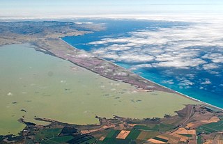
Lake Ellesmere / Te Waihora is a broad, shallow coastal lake or waituna, in the Canterbury region of the South Island of New Zealand. It is directly to the west of Banks Peninsula, separated from the Pacific Ocean by the long, narrow, sandy Kaitorete Spit, or more correctly Kaitorete Barrier. It lies partially in extreme southeastern Selwyn District and partially in the southwestern extension of the former Banks Peninsula District, which now is a ward in the city of Christchurch. The lake holds high historical and cultural significance to the indigenous Māori population and the traditional Māori name Te Waihora, means spreading waters. It has officially had a dual English/Māori name since at least 1938.

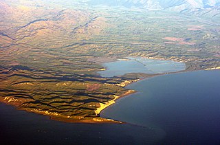
Lake Ōhau is a lake in the Mackenzie Basin in the South Island of New Zealand. The Hopkins and Dobson rivers fed into the northern end of Lake Ōhau. These rivers have their headwaters in the Southern Alps. The lake's outflow is the Ōhau River, which travels from the southeast corner of Lake Ōhau and feeds into the Waitaki River hydroelectric project. The Barrier range dominate the western side of Lake Ōhau, while the Ben Ohau range dominates the eastern side of Lake Ōhau. At the northern end of the lake, in between the Hopkins and Dobson rivers, lies the Naumann Range of mountains.

Ōkārito Lagoon is a coastal lagoon on the West Coast of New Zealand's South Island. It is located 130 kilometres (81 mi) south of Hokitika, and covers an area of about 3,240 hectares (12.5 sq mi), making it the largest unmodified coastal wetland in New Zealand. It preserves a sequence of vegetation types from mature rimu forest through mānuka scrub to brackish water that has been lost in much of the rest of the West Coast. The settlement of Ōkārito is at the southern end of the lagoon.

Westland Tai Poutini National Park is a national park located on the western coast of New Zealand's South Island. Established in 1960 as Westland National Park to commemorate the centenary of the European settlement of Westland District, it covers 1,320 square kilometres of largely mountainous terrain and forest. The park borders the Aoraki / Mount Cook National Park along the Main Divide of the Southern Alps, and includes many of the West Coast's glaciers, most notably including the Fox / Te Moeka o Tuawe and Franz Josef / Kā Roimata o Hine Hukatere glaciers.
Lake Grassmere / Kapara Te Hau is a New Zealand waituna-type lagoon in the northeastern South Island, close to Cook Strait. The lake is used for the production of salt.
Washdyke Lagoon is a brackish shallow coastal lagoon approximately 1 kilometre (0.62 mi) north of Timaru, South Canterbury, New Zealand. The lagoon has drastically reduced in size since 1881 when it was approximately 253 hectares, now it is less than 48 hectares (0.48 km2) in area. It is enclosed by a barrier beach that is 3 kilometres (1.9 mi) long and 3 metres (9.8 ft) above high tide at its largest point. The reduced lagoon size is due to the construction of the Timaru Port breakwater which is preventing coarse sediments from reaching and replenishing Washdyke Barrier. This is important as the lagoon and the surrounding 250 hectares are classified as a wildlife refuge and it demonstrates the role human structures have on coastline evolution.
Hook River is a natural watercourse in the southern Canterbury region of New Zealand's South Island. The river flows east from its source to the Wainono Lagoon, a fresh water lake beside the Pacific Ocean. On the way, it passes through the localities of Waiariari and Hook and is crossed by State Highway 1 and the Main South Line railway. Water from the river and an associated aquifer is used for agricultural purposes.

The Waihao River is a natural watercourse in the Canterbury region of New Zealand's South Island. It flows into the Wainono Lagoon near Studholme.

Lake Forsyth is a lake on the south-western side of Banks Peninsula in the Canterbury region of New Zealand, near the eastern end of the much larger Lake Ellesmere / Te Waihora. State Highway 75 to Akaroa and the Little River Rail Trail run along the north-western side of the lake.

The Estuary of the Heathcote and Avon Rivers / Ihutai is the largest semi-enclosed shallow estuary in Canterbury and remains one of New Zealand's most important coastal wetlands. It is well known as an internationally important habitat for migratory birds, and it is an important recreational playground and educational resource. It was once highly valued for mahinga kai.

The Greenstone and Caples Tracks form a tramping (hiking) 61 kilometres (38 mi) circuit which is located in the South Island of New Zealand. Each track can be completed by itself and are linked by the McKellar Saddle while the loop also links to several other tracks including the New Zealand Great Walk of the Routeburn Track as well as the Mavora Lakes Conservation Park tracks. All of these areas are part of the Te Wāhipounamu/South-West New Zealand World Heritage Area. In 2023, the Department of Conservation (DOC) and Ngāi Tahu released 18 takahē in the Greenstone Valley.

Waiau Glacier Coast Marine Reserve is a marine reserve of the West Coast Region of New Zealand's South Island. It covers an area of 4,641 hectares or 46 km2, from 11 km south from Kohuamarua Bluff near Ōkārito, to Omoeroa Bluff, and about 4 km out to sea.

Coopers Lagoon / Muriwai is a small coastal waituna-type lagoon in the Canterbury region of New Zealand, located approximately halfway between the mouth of the Rakaia River and the outlet of the much larger Lake Ellesmere / Te Waihora. While the present-day lagoon is separated from the nearby Canterbury Bight by approximately 100 metres (330 ft), the water of the lagoon is considered brackish and early survey maps show that, until recently, the lagoon was connected to the ocean by a small channel. The lagoon, along with the surrounding wetlands, has historically been an important mahinga kai for local Māori.

Punakaiki Marine Reserve is a marine reserve administered by the Department of Conservation. The reserve includes the area of sea surrounding the pancake rocks and blowholes at Dolomite Point, at Punakaiki on the West Coast Region of New Zealand's South Island. It also includes most of the coastline on the western edge of Paparoa National Park.

Tauparikākā Marine Reserve is a marine reserve located offshore about 20 kilometres (12 mi) north of Haast on the West Coast of New Zealand's South Island. It covers the area immediately offshore from Ship Creek, which is also known as Tauparikākā in Māori.
Sutherland Sound Marine Reserve is a marine reserve covering an area of 449 hectares of Sutherland Sound / Sutherland Sound, in Fiordland on New Zealand's South Island. It was established in 2005 and is administered by the Department of Conservation.
A waituna is a freshwater coastal lagoon on a mixed sand and gravel (MSG) beach, formed where a braided river meets a coastline affected by longshore drift. This type of waterbody is neither a true lake, lagoon nor estuary.
