Related Research Articles

The Northland Peninsula, called the North Auckland Peninsula in earlier times, is in the far north of the North Island of New Zealand. It is joined to the rest of the island by the Auckland isthmus, a narrow piece of land between the Waitematā Harbour and the Manukau Harbour in the middle of the Auckland metropolitan area. The peninsula is not conterminous with the local government area of Northland Region, which occupies the northern 80% of the peninsula. The southern section of the peninsula is administratively part of the Auckland Region.
The Opua Branch or Otiria-Opua Industrial Line, partially still operational as the Bay of Islands Vintage Railway, is a former section of the North Auckland Line in the Northland Region of New Zealand, between Otiria and the Bay of Islands township of Opua. The first section was constructed as a bush tramway in 1868 and converted to a railway in the next decade. Today the railway is partially used by the Bay of Islands Vintage Railway, which runs tourist services between Kawakawa and Lone Cow. The line's centrepiece is the section where it runs down along the main street of Kawakawa.
Marsden Point is a broad, flat peninsula that is the southern head of the Whangārei Harbour entrance on the east coast of Northland, New Zealand, 30 kilometres (19 mi) southeast of the city of Whangārei. It is the location of Marsden Point Oil Refinery and the Northport cargo port.
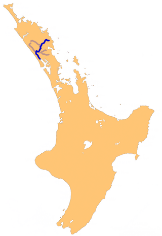
The Wairoa River in Northland New Zealand, sometimes referred to as the Northern Wairoa River, runs for 150 kilometres through the northern part of the North Auckland Peninsula. In the upper reaches, the river is formed from two separate rivers, the Mangakahia River and the Wairua River. The two streams meet to the northeast of Dargaville, becoming the Wairoa. It is the longest river in the Northland Region.

Titoki is a locality in the Mangakahia Valley of the Northland Region of New Zealand's North Island. Whangarei is 26 km to the east. The Wairua River passes to the east of Titoki, and the Mangakahia River to the west. A hydroelectric plant has been operating at Wairua Falls since 1916. It was upgraded to produce 5.4 Gwh per year in 2007.
The Arapaoa River is a northeastern arm of the Kaipara Harbour in Northland, New Zealand. Officially designated as a river, it is some 17 kilometres (11 mi) long and an average of 3 kilometres (2 mi) wide.
The Kaiikanui River is a river of Northland, New Zealand.
The Kaikou River is a river of the Northland Region of New Zealand's North Island. It flows initially north, then east, and finally south, from its source approximately halfway between Dargaville and Kaikohe, before joining with the Moengawahine Stream to become the Hikurangi River.
The Karukaru River is a river of New Zealand. A tributary of the Wairua River, it rises west of Maungatapere and flows westward into that river south of Titoki.
The Mangakahia River is a river of the Northland Region of New Zealand's North Island. It flows east from its sources in the Mataraua Forest, turning southeastward after about 20 kilometres (12 mi) on joining with the small Awarua River. It is joined by the Opouteke River near Pakotai, then turns east, until it is joined by the Hikurangi River. It then turns south again, passing Titoki and then joining with the Wairua River to form the Wairoa River approximately halfway between Whangarei and Dargaville.
The Mangapai River is a river of the Northland Region of New Zealand's North Island. It is perhaps better described as a silty arm of Whangārei Harbour, located 10 kilometres (6 mi) due south of Whangārei. Its average width is some 4 metres (13 ft), but the silty nature of its course means that the stream itself is far narrower.
The Māngere River is a river of the Northland Region of New Zealand's North Island. It flows generally westwards from its sources in hills northwest of Whangārei, meeting the Wairua River 10 kilometres (6 mi) northwest of Maungatapere.
The Ngunguru River is a river of the Northland Region of New Zealand's North Island. It initially flows southwest before turning east to flow into a long, wide estuary which empties into Ngunguru Bay to the northwest of Whangārei. The town of Ngunguru sits on the estuary's north bank at its opening to the bay.
The Pahi River is a river of the Northland Region of New Zealand's North Island. It flows generally west from its origins southwest of Maungaturoto, and the last few kilometres of its length form an upper silty arm of the Kaipara Harbour. It forms one of the arms of the Arapaoa River, in the northeastern part of the harbour's system.

The Taheke River is a river of the Northland Region of New Zealand's North Island. It flows north from its origins in hills to the east of Whangārei reaching the Waitangi River close to its mouth at Ngunguru Bay.
The Waiariki River is a river of the Northland Region of New Zealand's North Island. It is one of the upper tributaries of the Wairua River, which it reaches near the settlement of Waiotu, approximately halfway between Whangarei and Kawakawa.
The Waiotama River is a river of the Northland Region of New Zealand's North Island. It flows northwest from its origins south of Maungatapere to reach the Wairoa River 20 kilometres northeast of Dargaville.
The Wairua River is a river of Northland, New Zealand. It flows south-west from Hikurangi and joins the Mangakahia River between Titoki and Tangiteroria to form the Wairoa River, which runs past Dargaville to the Kaipara Harbour.
The Whakapara River is a river of the Northland Region of New Zealand's North Island. One of the headwaters of the Wairua River, it flows generally east from its sources close to the North Auckland Peninsula's east coast, and reaches the Wairua 5 km (3.1 mi) west of Otonga.

The Northland District Health Board is a district health board with the focus on providing healthcare to the Northland Region of New Zealand. In July 2022, the Northland DHB was merged into the national health service Te Whatu Ora.
References
- ↑ "River Water Quality". Northland Regional Council. Retrieved 3 May 2024.
- ↑ "Place name detail: Waiotu River". New Zealand Gazetteer. New Zealand Geographic Board . Retrieved 12 July 2009.