
Route 128, known as the Yankee Division Highway, is an expressway in the U.S. state of Massachusetts maintained by the Highway Division of the Massachusetts Department of Transportation (MassDOT). Spanning 57 miles (92 km), it is one of two beltways around Boston, and is known as the "inner" beltway, especially around areas where it is 15 miles (25 km) or less outside of Boston. The route's current southern terminus is at the junction of I-95 and I-93 in Canton, and it is concurrent with I-95 around Boston for 37.5 miles (60.4 km) before it leaves the interstate and continues on its own in a northeasterly direction towards Cape Ann. The northern terminus lies in Gloucester a few hundred feet from the Atlantic Ocean. All but the northernmost 3 miles are a freeway, with the remainder being an expressway. Its concurrency with I-95 makes up most of its length.

Middleton is a town in Essex County, Massachusetts, United States. The population was 9,779 at the 2020 census.

Peabody is a city in Essex County, Massachusetts, United States. The population was 54,481 at the time of the 2020 United States Census. Peabody is located in the North Shore region of Massachusetts, and is known for its rich industrial history.

Lynnfield is a town in Essex County, Massachusetts, in the United States. At the 2020 census, the town population was 13,000.

Burlington is a town in Middlesex County, Massachusetts, United States. The population was 26,377 at the 2020 census.
Reading is a town in Middlesex County, Massachusetts, United States, 16 miles (26 km) north of central Boston. The population was 25,518 at the 2020 census.

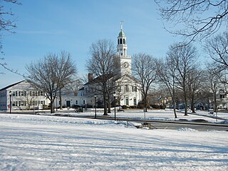
Wakefield is a town in Middlesex County, Massachusetts, in the Greater Boston metropolitan area, incorporated in 1812 and located about 12.5 mi (20.1 km) north-northwest of Downtown Boston. Wakefield's population was 27,090 at the 2020 census. Wakefield offers an assortment of activities around the local lake, Lake Quannapowitt.

Wilmington is a town in Middlesex County, Massachusetts, United States. Its population was 23,349 at the 2020 United States census.

The Minuteman Bikeway, also known as the Minuteman Commuter Bikeway, is a 10-mile (16-kilometre) paved multi-use rail trail located in the Greater Boston area of Massachusetts. It runs from Bedford to Alewife station, at the northern end of the Red Line in Cambridge, passing through the towns of Lexington and Arlington along the way. Also along the route are several notable regional sites, including Alewife Brook Reservation, the Cyrus Dallin Art Museum, Spy Pond, "Arlington’s Great Meadows", the Battle Green in Lexington, and Hanscom Air Force Base.

The Lowell Line is a railroad line of the MBTA Commuter Rail system, running north from Boston to Lowell, Massachusetts. Originally built as the New Hampshire Main Line of the Boston & Lowell Railroad and later operated as part of the Boston & Maine Railroad's Southern Division, the line was one of the first railroads in North America and the first major one in Massachusetts.

The Mass Central Rail Trail (MCRT) is a partially completed rail trail between Northampton, Massachusetts and Boston along the former right-of-way (ROW) of the Massachusetts Central Railroad. It currently has 59 miles (95 km) open, and 94.5 miles (152.1 km) are open or protected for trail development. When complete, it will be 104 miles (167 km) long through Central Massachusetts and Greater Boston, forming the longest rail trail in New England. Many sections of the trail, including the Norwottuck Branch of the Mass Central Rail Trail and the Somerville Community Path, have been developed as separate projects but serve as part of the complete Mass Central Rail Trail. The Norwottuck Network, a 501(c)(3) nonprofit that supports the build and operation of the MCRT, maintains interactive maps of the MCRT and rail trails that connect with the MCRT, and other Massachusetts trails.

Interstate 95 (I-95) is a part of the Interstate Highway System that parallels the East Coast of the United States from Miami, Florida, in the south to Houlton, Maine, in the north. In the US state of Massachusetts, it spans 92 miles (148 km) along a north–south axis. It is the third-longest Interstate Highway in Massachusetts, behind I-90 and I-495, while I-95 in full is the longest north–south Interstate and sixth-longest Interstate Highway in the US.
The Haverhill Line is a branch of the MBTA Commuter Rail system, running north from downtown Boston, Massachusetts through the cities and towns of Malden, Melrose, Wakefield, Reading, Wilmington, Andover, North Andover, Lawrence, and Haverhill.
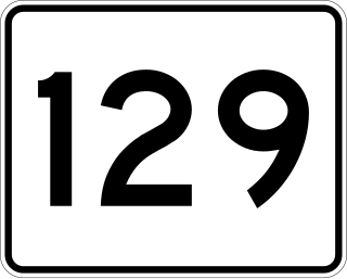
Route 129 is a 34.08-mile-long (54.85 km) east–west Massachusetts state route that runs from Route 4 and Route 110 in Chelmsford to Route 114 in Marblehead. Along the way it intersects several major highways including U.S. Route 3 in Chelmsford, Interstate 93 (I-93) in Wilmington, I-95 and Route 128 in Wakefield, and US 1 in Saugus and Lynnfield.

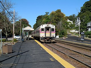
Wakefield station is an MBTA Commuter Rail station in Wakefield, Massachusetts served by the Haverhill Line. The station has two side platforms, which are not accessible, serving the line's two tracks. The station building, constructed in 1889, was listed on the National Register of Historic Places in 1989 as Wakefield Upper Depot.

The Newburyport Railroad was a railroad that came about from the merger of three small rail companies into one rail line to compete with the Eastern Railroad for service between Newburyport and Boston, Massachusetts. The Newburyport Railroad ran from Newburyport to Wakefield, Massachusetts, where it connected with the Boston and Maine (B&M) for service into Boston.

The Assabet River Rail Trail (ARRT) is a partially-completed multi-use rail trail running through the cities and towns of Marlborough, Hudson, Stow, Maynard, and Acton, Massachusetts, United States. It is a conversion of the abandoned Marlborough Branch of the Fitchburg Railroad. The right-of-way parallels the Assabet River in the trail's midsection. At the north end it veers north to the South Acton MBTA train station while the south end veers south to Marlborough. When fully completed, the end-to-end length will be 12.5 miles (20.1 km). As of June 2020, the southwest 5.1-mile (8.2 km) portion of the trail from Marlborough to Hudson and the northeast 3.4-mile (5.5 km) portion running from the South Acton MBTA station to the Maynard–Stow border are completed. No current plans exist for paving the 4.0-mile (6.4 km) gap in Stow and Hudson between the two trail ends.

This is a list of roundabouts in the state of Massachusetts in the United States. Intersections that are called traffic circles or roundabouts in the rest of the US are referred to as "rotaries" in Massachusetts, as well as other parts of New England including parts of Connecticut, New Hampshire, Maine Rhode Island, & Vermont.

The Boston & Northern Street Railway Company (B&N) was a horse-drawn and electric streetcar railroad operated on the streets of Boston, Massachusetts, and communities to the north. Founded in 1859 as the Lynn and Boston Railroad (L&B), via lease and merger it became a primary mass transit provider for northeastern Massachusetts and New Hampshire. Its immediate successor was the Bay State Street Railway (Bay State), and its modern successor is the state-run Massachusetts Bay Transportation Authority (MBTA).
