
The Holy Island of Lindisfarne, commonly known as either Holy Island or Lindisfarne, is a tidal island off the northeast coast of England, which constitutes the civil parish of Holy Island in Northumberland. Holy Island has a recorded history from the 6th century AD; it was an important centre of Celtic Christianity under Saints Aidan of Lindisfarne, Cuthbert, Eadfrith of Lindisfarne and Eadberht of Lindisfarne. After the Viking invasions and the Norman conquest of England, a priory was reestablished. A small castle was built on the island in 1550.

Bamburgh is a village and civil parish on the coast of Northumberland, England. It had a population of 454 in 2001, decreasing to 414 at the 2011 census.

Edlingham Castle is a small castle ruin, having Scheduled Ancient Monument and Grade I listed building status, in the care of English Heritage. It is located in a valley to the west of Alnwick, Northumberland, England. It has been described as "...one of the most interesting in the county", by Nikolaus Pevsner, the architectural historian. Edlingham itself is little more than a hamlet with a church alongside the castle.
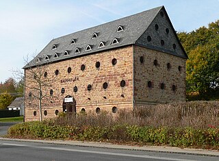
A tithe barn was a type of barn used in much of northern Europe in the Middle Ages for storing rents and tithes. Farmers were required to give one-tenth of their produce to the established church. Tithe barns were usually associated with the village church or rectory, and independent farmers took their tithes there. The village priests did not have to pay tithes—the purpose of the tithe being their support. Some operated their own farms anyway. The former church property has sometimes been converted to village greens.

The River Coquet runs through the county of Northumberland, England, discharging into the North Sea on the east coast at Amble. It rises in the Cheviot Hills on the border between England and Scotland, and follows a winding course across the landscape. The upper reaches are bordered by the Otterburn Ranges military training ground, and are crossed by a number of bridges built in the 20th century. It passes a number of small villages and hamlets, and feeds one of the lakes created by extraction of gravel that form the Caistron Nature Reserve, before reaching the town of Rothbury, where it is crossed by a grade II listed bridge. Below the town is Thrum Mill, the restoration of which was featured on Channel 4 television.

Piercebridge is a village and civil parish in the borough of Darlington and the ceremonial county of Durham, England. The population of the civil parish as of the 2011 census was 113. It is situated a few miles west of the town of Darlington. It is on the site of a Roman fort of AD 260–270, which was built at the point where Dere Street crossed the River Tees. Part of the fort is under the village green. The village is sited where the York-Newstead Roman road known as Dere Street crosses the River Tees.

Wressle Castle is a ruined palace-fortress in the East Riding of Yorkshire, England, built for Thomas Percy in the 1390s. It is privately owned and not open to the public. Wressle Castle originally consisted of four ranges built around a central courtyard; there was a tower at each corner, and the structure was entered through a gatehouse in the east wall, facing the village.

Kyloe is a civil parish in the county of Northumberland, about 8 miles (13 km) south-east of Berwick-on-Tweed.

Aydon Castle, previously sometimes called Aydon Hall, is a fortified manor house at Aydon near to the town of Corbridge, Northumberland, England. It is a Scheduled Ancient Monument, and is designated by English Heritage as a Grade I listed building.
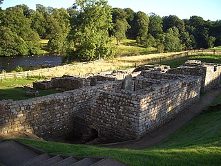
Cilurnum or Cilurvum was a fort on Hadrian's Wall mentioned in the Notitia Dignitatum. It is now identified with the fort found at Chesters near the village of Walwick, Northumberland, England. It was built in 123 AD, just after the wall's completion.

Belsay Castle is a 14th-century medieval castle situated at Belsay, Northumberland, England. It is a Scheduled Ancient Monument and a Grade I listed building.

John Edward Errington was an English civil engineer, particularly noted for his work on railway construction in the United Kingdom.
William Errington was High Sheriff of Northumberland.
Beaufront Castle is a privately owned 19th-century country house near Hexham, Northumberland, England. It is a Grade I listed building.

Simonburn is a small human settlement in Northumberland, England.

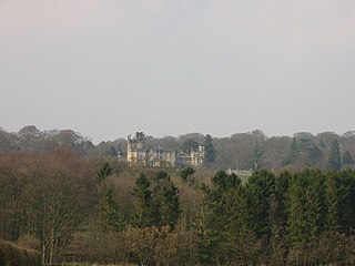
Chesters is an 18th-century country mansion situated adjacent to Hadrian's Wall and the Roman fort of Cilurnum at Humshaugh, Northumberland, England. It is a Grade II* listed building.
William Errington was an English Roman Catholic priest, and founder of Sedgley Park School.

Sandhoe Hall, also once known as Sandhoe House, is a 19th-century country house situated at Sandhoe, Northumberland. It is a Grade II listed building.

Newbrough Hall is an early 19th-century country house at Newbrough, about 5 miles (8 km) west of Hexham, Northumberland, England. It is a Grade II* listed building.

Saighton Grange originated as a monastic grange. It was later converted into a country house and, as of 2013, the building is used as a school. It is located in Saighton, Cheshire, England. The only surviving part of the monastic grange is the gatehouse, which is recorded in the National Heritage List for England as a designated Grade I listed building, and is one of only two surviving monastic manorial buildings in Cheshire, the other being Ince Manor. The rest of the building is listed at Grade II, as is its chapel.

