Related Research Articles

Chillicothe is a city in Hardeman County, in the U.S. state of Texas. The population was 707 at the 2010 census.
Aber-banc is a village in the Welsh county of Ceredigion.

CJPT-FM is a radio station, airing at 103.7 FM in Brockville, Ontario, Canada. The station, owned by Bell Media, airs an adult hits format branded as 103.7 Bob FM.
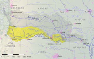
The Beaver River is an intermittent river, 280 miles (450 km) long, in western Oklahoma and northern Texas in the United States. It is a tributary of the North Canadian River, draining an area of 11,690 square miles (30,300 km2) in a watershed that extends to northeastern New Mexico and includes most of the Oklahoma Panhandle.
Sweetwater Creek is a stream in northern Texas and western Oklahoma. It is a tributary to the North Fork of the Red River.
The Rural Municipality of Riverside is a former rural municipality (RM) in the Canadian province of Manitoba. It was originally incorporated as a rural municipality on December 22, 1883. It ceased on January 1, 2015 as a result of its provincially mandated amalgamation with the RM of Strathcona to form the Rural Municipality of Prairie Lakes.
Chacon Creek is a small stream of water located in Webb County, Texas, US, which runs through Laredo. The creek is formed 6 miles from Webb and runs southwest for 20 miles until it connects to the Rio Grande. Chacon was dammed in 1951 in east Laredo to form Lake Casa Blanca, a 1,680 acres (6.8 km²) lake. The terrain surrounding the creek is mostly clay. The vegetation surrounding the creek is mostly made up of mesquite, cacti and grasses. Chacon Creek is cross by several highways in Laredo, including United States Route 59, Texas State Highway Loop 20, Texas State Highway Spur 400, Texas State Highway 359 and United States Route 83.

Zacate Creek is inside Laredo, Texas city limits and runs southwest for 10 miles until it connects to the Rio Grande. Zacate Creek has several ditches leading to it. The terrain surrounding the creek is mostly clay. The vegetation surrounding the creek is mostly made up of mesquite, cacti, and grasses. Zacate Creek and branches cross several highways in Laredo, Texas among them are: Interstate 35, United States Route 59, Texas State Highway Spur 400, Texas State Highway 359, and United States Route 83. The northern branch of the Zacate Creek has a small dam which formed a pond located in Northeast Laredo which is usually filled during storms. The city of Laredo has developed the Zacate Creek Park and the Zacate Creek Greenway, a three mile trail near the creek.
San Idelfonso Creek is a small stream of water located in Webb County, Texas which runs through Laredo, Texas. The creek is formed within east Laredo and runs southwest for 8 miles until connecting to the Rio Grande. San Ildefonso Creek was dammed in east Laredo to form San Ildefonso Creek Lake, the second largest Lake in Laredo. The terrain surrounding the creek is mostly clay and sandy loams. The vegetation surrounding the creek is mostly made up of mesquite, cacti, chaparral, hardwoods and grasses. San Idelfonso Creek crosses two major highways in Laredo, Texas among them are: Texas State Highway 359 and United States Route 83
Sombrerillito Creek is a small stream of water located in Webb County, Texas which runs through Laredo, Texas. The creek is formed 13 miles north of Laredo and runs southwest for 16 miles until connecting to the Rio Grande. Sombrerillito Creek was dammed in northwest Laredo to form Sombrerillito Creek Lake, the third largest lake in Laredo. The terrain surrounding the creek is mostly clay and sandy loams. The vegetation surrounding the creek is mostly made up of mesquite, cacti, chaparral, hardwoods and grasses. Sombrerillito Creek crosses one major highway in Laredo, Texas among them are: Farm to Market Road 1472.
Santa Isabel Creek is a small stream of water located in Webb County, Texas which runs through Laredo, Texas. The creek is formed 32 miles from Callaghan, Texas and runs southwest for 33 mi (53 km) until the creek connects to the Rio Grande. The terrain surrounding the creek is mostly clay. The vegetation surrounding the creek is mostly made up of mesquite, cacti, and grasses. Santa Isabel Creek crosses Three major highways in Laredo, Texas among them are: Farm to Market Road 1472, Texas State Highway 255, and United States Route 83.
San Ygnacio Creek is a small stream of water located in Webb County, Texas which runs through Laredo, Texas. The creek is formed 11 miles northwest of Laredo, Texas and runs southwest for 12 mi (19 km) until the creek connects to the Lake Casa Blanca. The terrain surrounding the creek is mostly clay. The vegetation surrounding the creek is mostly made up of mesquite, cacti, and grasses. San Ygnacio Creek does not cross any major highway.
Odell is an unincorporated community in Wilbarger County, Texas, United States. According to the Handbook of Texas, the community had an estimated population of 131 in 2000.

Sawmill Brook is a tributary of Lawrence Brook in northwestern East Brunswick, New Jersey in the United States.
Waco is an unincorporated community in Giles County, Tennessee, formerly known as "Old Lynville". It is located at the crossroads of U.S. Route 31 and State Route 129.
Goose Creek is a small stream in Hillsdale, Jackson and Lenawee counties in the U.S. state of Michigan. It is a tributary of the River Raisin. The headwaters form in Somerset Township in northeast Hillsdale County flowing northeast to join the River Raisin just north of the village of Brooklyn. The total length of the creek is approximately 12 miles (19 km). The Goose Greek subbasin covers an area of 40 sq mi (100 km2) with 44% used for agriculture and 38% forest, wetlands, and grasslands. Only about 12% of the watershed is made up of urban development. Of all the subbasins within the River Raisin watershed, Goose Creek has maintained the largest share of wetlands and maintains the lowest levels of pollutants.
Sheep Creek is a geographical place name. With variations, the name is given to hundreds of bodies of water, roads, canals, reservoirs and populated areas in the United States and other countries. It is the name of a tributary to Lockyear Creek in Queensland, Australia, and the name of at least three bodies of water in Canada. The U.S. state of Montana has 85 different locales that bear that name or a derivation. The U.S. state of Idaho has 92 natural and man-made areas that incorporate Sheep Creek into their names. Nature areas that include trails named Sheep Creek can be found in Canada's Yukon Territory, Colorado's Larimer County and in Utah's Bryce Canyon National Park.
Bandera Creek is a stream in Bandera County, Texas, in the United States.
Pickles Creek is a stream in the U.S. state of South Dakota.
Ramos is a census-designated place (CDP) in Starr County, Texas, United States. It is a new CDP formed from part of the Roma Creek CDP prior to the 2010 census with a population of 116.
References
- "An Analysis of Texas Waterways" . Retrieved 2006-05-04.
- USGS Hydrologic Unit Map - State of Texas (1974)
Coordinates: 34°22′33″N99°23′58″W / 34.37583°N 99.39944°W
| | This article related to a river in Texas is a stub. You can help Wikipedia by expanding it. |