
A swing bridge is a movable bridge that has as its primary structural support a vertical locating pin and support ring, usually at or near to its center of gravity, about which the swing span can then pivot horizontally as shown in the animated illustration to the right. Small swing bridges as found over canals may be pivoted only at one end, opening as would a gate, but require substantial underground structure to support the pivot.

The Arthur Ravenel Jr. Bridge is a cable-stayed bridge over the Cooper River in South Carolina, US, connecting downtown Charleston to Mount Pleasant. The bridge has a main span of 1,546 feet (471 m), the third longest among cable-stayed bridges in the Western Hemisphere. It was built using the design–build method and was designed by Parsons Brinckerhoff.

The John P. Grace Memorial Bridge, or the Cooper River Bridge as it was familiarly known, was a cantilever bridge that crossed the Cooper River in Charleston, South Carolina. It opened on August 8, 1929, and was built by the Cooper River Bridge Company. Shortridge Hardesty of Waddell & Hardesty, a New York City-based engineering firm, designed the bridge.

Burnet Rhett Maybank was a three-term US senator, the 99th governor of South Carolina, and mayor of Charleston, South Carolina. He was the first governor from Charleston since the American Civil War (1861-1865) and one of only twenty people in United States history to have been elected mayor, governor, and United States senator. During his tenure in the Senate, Maybank was a powerful ally of President Franklin D. Roosevelt. His unexpected death on September 1, 1954, from a heart attack, led to Strom Thurmond being elected senator.

The Paul Gelegotis Bridge, also known as the Stono Bridge, is located in Charleston, South Carolina, United States; it connects James Island and Johns Island on SC 700. This bridge opened in late 2003, on the historically significant site of a series of former Stono Bridges.
Evening Post Industries is a privately held American media company, based in Charleston, South Carolina, United States. It has been led by four generations of the Manigault family.

McLeod Plantation is a former slave plantation located on James Island, South Carolina, near the intersection of Folly and Maybank roads at Wappoo Creek, which flows into the Ashley River. The plantation is considered an important Gullah heritage site, preserved in recognition of its cultural and historical significance to African-American and European-American cultures.

The James B. Edwards Bridge, also referred to as the Wando River Bridge, is a pair of pre-cast post-tensioned concrete box girder bridges that span the Wando River between Mount Pleasant and Daniel Island on Interstate 526 (I-526) in South Carolina.

The Matanzas Pass Bridge is a bridge located in Fort Myers Beach, Florida. It carries State Road 865 between the Florida mainland and Estero Island, which is a major tourist destination. The bridge is one of the island's two connections to the mainland. The other is the Bonita Beach Causeway on the south end of the island.
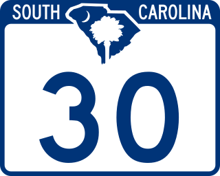
South Carolina Highway 30 is a 3.050-mile-long (4.908 km) freeway in Charleston, South Carolina. The freeway travels from SC 171 on James Island to U.S. Route 17 (US 17) in downtown Charleston.
Riverland Terrace is a historic neighborhood in Charleston, South Carolina. It was first developed starting in 1925. It is one of James Island, South Carolina's oldest neighborhoods. The Terrace is located 10 minutes west of downtown Charleston along Wappoo Creek and the inland waterway. The neighborhood boasts a public boat landing, Charleston Municipal Golf Course, a playground, five restaurants and numerous antique shops.

The John F. Limehouse Memorial Bridge, located about 15 miles (24 km) west of downtown Charleston, South Carolina, was completed in 2003. It replaced an obsolete low-level swing bridge over the Stono River. The current bridge, which crosses a channel between Johns Island and St. Andrews Parish, an area generally called West Ashley, was completed under a partnership between the South Carolina Department of Transportation (SCDOT) and the United States Coast Guard.

The Ben Sawyer Bridge is a swing bridge that connects the town of Mount Pleasant with Sullivan's Island in South Carolina. The bridge swings on its central axis to open for boat traffic which is too tall to clear the bridge, and has an operator's house in the center of the swing span from which a tender can operate the bridge. The bridge was originally constructed in 1945, but the steel superstructure for the approach spans and swing span was replaced in 2010, albeit retaining the same general appearance.
The McKinley Washington Jr. Bridge, or the Dawhoo River Bridge, connects Edisto Island on the coast of South Carolina to the mainland. It carries South Carolina Highway 174. The bridge is named for McKinley Washington Jr., who served in the South Carolina General Assembly, representing the area and leading the effort to appropriate funds to replace the bridge.
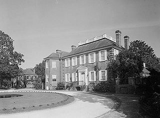
The Fenwick Hall, which is also known as Fenwick Castle, is a plantation house built about 1730 on Johns Island, South Carolina, across the Stono River from James Island and Charleston. It is located between River Road and Penneys Creek. It was named to the National Register of Historic Places on February 23, 1972.

South Carolina Highway 700 (SC 700) is a 20.380-mile (32.798 km) state highway in the U.S. state of South Carolina. Known for most of its length as Maybank Highway, the state highway travels from a dead end in Rockville east to U.S. Route 17 (US 17) in Charleston. SC 700 connects Charleston with James Island, Johns Island, and Wadmalaw Island in southwestern Charleston County.
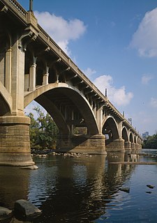
Gervais Street Bridge is a historic bridge in South Carolina in the United States and it is listed on the National Register of Historic Places. It is an arch bridge constructed from reinforced concrete. Construction began in 1926 and the bridge was completed in 1928. It was added to the National Register of Historic Places in 1980.

The James B. Garrison Bridge are two automobile bridges spanning the Pee Dee River/Lake Tillery, between Stanly and Montgomery Counties. The bridges carry NC 24/NC 27/NC 73.
The Georgia–Carolina Memorial Bridge was a highway crossing over the Savannah River between the states of Georgia and South Carolina that was in service from 1927 to 1981. The completion of this bridge marked the beginning of the end for Savannah River ferry traffic.
Yeamans Hall Club is a country club built on a 1100-acre tract about 12 miles from Charleston, South Carolina, along Goose Creek on the site of a 17th-century plantation.

