
The Shire of Yarra Ranges is a local government area in Victoria, Australia, located in the outer eastern and northeastern suburbs of Melbourne extending into the Yarra Valley and Dandenong Ranges. It has an area of 2,469.9 square kilometres (953.6 sq mi), and at the 2016 Australian census, it had a population of 149,537.

Launching Place is a town in Victoria, Australia, 54 km east of Melbourne's central business district. Its local government area is the Shire of Yarra Ranges. At the 2011 census, Launching Place had a population of 2,492.
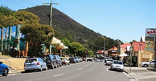
Millgrove is a small town in Victoria, Australia, 63 km east of Melbourne's central business district. Its local government area is the Shire of Yarra Ranges. At the 2016 census, Millgrove had a population of 1,653.

Seville is a town to the east of Melbourne, the capital city of Victoria, Australia, along Warburton Highway. Its local government area is the Shire of Yarra Ranges and sits within the Yarra Valley wine region. At the 2016 census, Seville had a population of 2,378.
Wandin East is a town in Victoria, Australia, 45 km east from Melbourne's central business district. Its local government area is the Shire of Yarra Ranges. At the 2006 census, Wandin East had a population of 506.
Warburton is a country town in Victoria, Australia, 72 kilometres east of Melbourne's central business district. Its local government area is the Shire of Yarra Ranges. At the 2016 census, Warburton had a population of 2,012 people.
Mount Evelyn is a suburb in Melbourne, Victoria, Australia, 37 km north-east of Melbourne's central business district. Its local government area is the Shire of Yarra Ranges. At the 2011 Census, Mount Evelyn had a population of 9,374 with an exact split of males and females.

Wesburn is a town in Victoria, Australia, 62 km east from Melbourne's central business district. Its local government area is the Shire of Yarra Ranges. At the 2016 census, Wesburn had a population of 1,019. Predominantly rural in nature, the township has a narrow ribbon of residential dwellings along and branching off the Warburton Highway.
Woori Yallock is a town in Victoria, Australia. It is in the Shire of Yarra Ranges local government area, 56 kilometres (35 mi) east of the central business district of Melbourne. At the 2011 census, Woori Yallock had a population of 2806.
Yarra Junction is a town in Victoria, Australia, 55 km (34 mi) east from Melbourne's central business district. It sits at the junction of the Yarra and Little Yarra Rivers. Its local government area is the Shire of Yarra Ranges. At the 2016 census, Yarra Junction had a population of 2,549. Yarra Junction is a small town full of bakeries and entertainment. Yarra Junction has great pubs.

Port Campbell is a coastal town in Victoria, Australia. The town is on the Great Ocean Road, west of the Twelve Apostles, in the Shire of Corangamite. At the 2016 census, Port Campbell had a population of 478.

Hoddles Creek is a bounded rural locality near Melbourne in Victoria, Australia. Its local government area is the Shire of Yarra Ranges. At the 2016 census, Hoddles Creek had a population of 627, compared to 609 at the 2011 census.

Powelltown is a town in Victoria, Australia, 70 km east of Melbourne's central business district. Its local government area is the Shire of Yarra Ranges. At the 2016 Census, Powelltown had a population of 217.

Cardross is a small town approximately 15 km south east of Mildura, in north western Victoria, Australia. At the 2016 census, Cardross and the surrounding area had a population of 821. It was the site of a road fatality in February 2006, in which six teenagers were killed in a hit-run accident.

Lancaster is a locality in the Goulburn Valley region of Victoria, Australia. The town is located in Shire of Campaspe and the City of Greater Shepparton. At the 2016 census, Lancaster had a population of 393.

The Shire of Upper Yarra was a local government area centred on the upper reaches of the Yarra Valley, about 60 kilometres (37 mi) east of Melbourne, the state capital of Victoria, Australia, extending eastwards into Victoria's interior. The shire covered an area of 1,732 square kilometres (668.7 sq mi), and existed from 1888 until 1994.

Tyntynder is a town in the south-east of the Mallee region of Victoria, Australia. It has an Australian rules football team in the Central Murray Football League. Tyntynder post office opened on 4 May 1894, then it was renamed Nyah Post Office 1 November 1894, but closed on 8 August 1944. At the 2016 census, Tyntynder and the surrounding area had a population of 151.

McMahons Creek is a bounded rural locality in Victoria, Australia, on the Warburton–Woods Point Road bordering the Yarra Ranges National Park. Its local government area is the Shire of Yarra Ranges. At the 2016 census, McMahons Creek had a population of 125.
Reefton is a bounded rural locality in Victoria, Australia, on the Warburton Woods Point Road. Its local government area is the Shire of Yarra Ranges. At the 2006 Census, Reefton had a population of 325. The Upper Yarra Reservoir lies within the locality.

Wandin North is a suburb in Melbourne, Victoria, Australia, 40 km east from Melbourne's central business district. Its local government area is the Shire of Yarra Ranges. At the 2016 census, Wandin North had a population of 3,051.


