Ward Township, Clarke County, Iowa

Last updated
Ward Township
Township
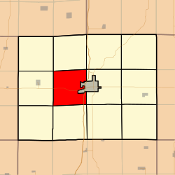
Map highlighting Ward Township, Clarke County, Iowa.svg
Location in Clarke County
Coordinates: 41°01′28″N093°50′28″W / 41.02444°N 93.84111°W / 41.02444; -93.84111 Coordinates: 41°01′28″N093°50′28″W / 41.02444°N 93.84111°W / 41.02444; -93.84111
Country Flag of the United States.svg  United States
State Flag of Iowa.svg  Iowa
County Clarke
Area
  Total 32.92 sq mi (85.27 km2)
  Land 32.77 sq mi (84.88 km2)
  Water 0.15 sq mi (0.38 km2)  0.45%
Elevation 1,142 ft (348 m)
Population (2000)
  Total 228
  Density 7/sq mi (2.7/km2)
GNIS feature ID 0468892

Ward Township is a township in Clarke County, Iowa, USA. As of the 2000 census, its population was 228.

A township in the United States is a small geographic area.

Clarke County, Iowa County in the United States

Clarke County is a county located in the U.S. state of Iowa. As of the 2010 census, the population was 9,286. The county seat is Osceola. The county was formed in January 1846, one of twelve counties established by legislative action in a comprehensive act. It was named for James Clarke, a Governor of the Iowa Territory.

Iowa State of the United States of America

Iowa is a state in the Midwestern United States, bordered by the Mississippi River to the east and the Missouri River and Big Sioux River to the west. It is bordered by six states; Wisconsin to the northeast, Illinois to the east, Missouri to the south, Nebraska to the west, South Dakota to the northwest and Minnesota to the north.

Contents

Geography

Ward Township covers an area of 32.92 square miles (85.3 km2) and contains no incorporated settlements. According to the USGS, it contains one cemetery, Cox.

United States Geological Survey Scientific agency of the United States government

The United States Geological Survey is a scientific agency of the United States government. The scientists of the USGS study the landscape of the United States, its natural resources, and the natural hazards that threaten it. The organization has four major science disciplines, concerning biology, geography, geology, and hydrology. The USGS is a fact-finding research organization with no regulatory responsibility.

Related Research Articles

Denison Township, Crawford County, Iowa Township in Iowa, United States

Denison Township is a township in Crawford County, Iowa, USA. As of the 2000 census, its population was 7,757.

Hayes Township, Crawford County, Iowa Township in Iowa, United States

Hayes Township is a township in Crawford County, Iowa, USA. As of the 2000 census, its population was 274.

Washington Township, Crawford County, Iowa Township in Iowa, United States

Washington Township is a township in Crawford County, Iowa, USA. As of the 2000 census, its population was 293.

Willow Township, Crawford County, Iowa Township in Iowa, United States

Willow Township is a township in Crawford County, Iowa, USA. As of the 2000 census, its population was 158.

Hickory Grove Township, Scott County, Iowa Township in Iowa, United States

Hickory Grove Township is a township in Scott County, Iowa, USA. As of the 2000 census, its population was 671.

Union Township, Butler County, Kansas Township in Kansas, United States

Union Township is a township in Butler County, Kansas, USA. As of the 2000 census, its population was 226.

Pleasant Valley Township, Cowley County, Kansas Township in Kansas, United States

Pleasant Valley Township is a township in Cowley County, Kansas, USA. As of the 2000 census, its population was 838.

Buckeye Township, Dickinson County, Kansas Township in Kansas, United States

Buckeye Township is a township in Dickinson County, Kansas, USA. As of the 2000 census, its population was 437.

Ellsworth Township, Ellsworth County, Kansas Township in Kansas, United States

Ellsworth Township is a township in Ellsworth County, Kansas, USA. As of the 2000 census, its population was 797.

Mulberry Township, Ellsworth County, Kansas Township in Kansas, United States

Mulberry Township is a township in Ellsworth County, Kansas, USA. As of the 2000 census, its population was 44.

Boardman Township, Clayton County, Iowa Township in Iowa, United States

Boardman Township is a township in Clayton County, Iowa, USA. As of the 2000 census, its population was 1,832.

Cass Township, Clayton County, Iowa Township in Iowa, United States

Cass Township is a township in Clayton County, Iowa, USA. As of the 2000 census, its population was 1,835.

Giard Township, Clayton County, Iowa Township in Iowa, United States

Giard Township is a township in Clayton County, Iowa, USA. As of the 2000 census, its population was 463.

Jefferson Township, Clayton County, Iowa Township in Iowa, United States

Jefferson Township is a township in Clayton County, Iowa, USA. As of the 2000 census, its population was 2,721.

Marion Township, Clayton County, Iowa Township in Iowa, United States

Marion Township is a township in Clayton County, Iowa, USA. As of the 2000 census, its population was 389.

Millville Township, Clayton County, Iowa Township in Iowa, United States

Millville Township is a township in Clayton County, Iowa, USA. As of the 2000 census, its population was 471.

Read Township, Clayton County, Iowa Township in Iowa, United States

Read Township is a township in Clayton County, Iowa, USA. As of the 2000 census, its population was 300.

Eden Township, Clinton County, Iowa Township in Iowa, United States

Eden Township is a township in Clinton County, Iowa, USA. As of the 2000 census, its population was 856.

Eureka Township, Greenwood County, Kansas Township in Kansas, United States

Eureka Township is a township in Greenwood County, Kansas, USA. As of the 2000 census, its population was 451.

Warren Township, Story County, Iowa Township in Iowa, United States

Warren Township is a township in Story County, Iowa, USA. As of the 2000 census, its population was 562.

References