
The Brisbane Water National Park is a protected national park that is located in the Central Coast region of New South Wales, in eastern Australia. The 11,506-hectare (28,430-acre) national park is situated 47 kilometres (29 mi) north of Sydney, 10 kilometres (6.2 mi) west of Woy Woy, and 12 kilometres (7.5 mi) southwest of Gosford.

Goobang is a national park located in New South Wales, Australia, 296 kilometres (184 mi) northwest of Sydney. It protects the largest remnant forest and woodland in the central west region of the state, where interior and coastal New South Wales flora and fauna species overlap. Originally named Herveys Range by John Oxley in 1817, the area was reserved in 1897 as state forest because of its importance as a timber resource, and was designated a national park in 1995.

The Hunter Region, also commonly known as the Hunter Valley, is a region of New South Wales, Australia, extending from approximately 120 km (75 mi) to 310 km (193 mi) north of Sydney. It contains the Hunter River and its tributaries with highland areas to the north and south. Situated at the northern end of the Sydney Basin bioregion, the Hunter Valley is one of the largest river valleys on the NSW coast, and is most commonly known for its wineries and coal industry.

The Sydney Basin is an interim Australian bioregion and is both a structural entity and a depositional area, now preserved on the east coast of New South Wales, Australia and with some of its eastern side now subsided beneath the Tasman Sea. The basin is named for the city of Sydney, on which it is centred.
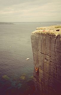
Beecroft Peninsula is the northern headland of Jervis Bay, on Australia's east coast. On the western and southern sides of the peninsula steep sandstone cliffs rise out of the ocean, up to 91 metres at its southernmost point, Point Perpendicular. White sandy beaches are found along the northern, eastern and southern sides interspersed with numerous intertidal reefs.

Barrenjoey is a locality in the suburb of Palm Beach, at the most northern tip of Pittwater. The headland is made up primarily of sandstones of the Newport Formation, the top third is a cap of Hawkesbury sandstone. Around 10,000 years ago the headland was cut off from the mainland due to the rising sea level; subsequent buildup of a sand spit or tombolo reconnected the island to the mainland. It is the location of the Barrenjoey Head Lighthouse, a lighthouse that was first lit in 1881. In 1995 Barrenjoey was gazetted into Ku-ring-gai Chase National Park.

The Cumberland Plain, an IBRA biogeographic region, is a relatively flat region lying to the west of Sydney CBD in New South Wales, Australia. Cumberland Basin is the preferred physiographic and geological term for the low-lying plain of the Permian-Triassic Sydney Basin found between Sydney and the Blue Mountains, and it is a structural sub-basin of the Sydney Basin.

The Sydney Turpentine-Ironbark Forest (STIF) is one of six main indigenous forest communities of Sydney, New South Wales, Australia, that is typically in the Inner West region of Sydney. It is also among the three of these plant communities which have been classified as Endangered, under the New South Wales government's Threatened Species Conservation Act 1995, with only around 0.5% of its original pre-settlement range remaining. As of 26 August 2005, the Australian Government reclassified Sydney Turpentine-Ironbark Forest as a "Critically Endangered Ecological Community", under the Commonwealth's Environment Protection and Biodiversity Conservation Act 1999.

The Paroo-Darling National Park is a protected national park that is located in the Far West region of New South Wales, in eastern Australia. The 178,053-hectare (439,980-acre) national park spans two distinct regions in the outback area. This region covers the arid catchments of the Paroo River and the Paroo-Darling confluence to the south.

The Littoral Rainforests of New South Wales is a group of fragmented and endangered ecological communities found by the coast in eastern Australia. Much of this seaside form has been destroyed by mining, tourist development or housing. It is threatened by extinction in the near future. 90% of the 433 sites are less than ten hectares in size. Littoral rainforest amounts to 0.6% of the rainforests in New South Wales.

The Dharawal National Park is a protected national park that is located in the Illawarra region of New South Wales, in eastern Australia. The 6,508-hectare (16,080-acre) national park is situated between the Illawarra Range and the Georges River and is approximately 45 kilometres (28 mi) south west of Sydney. There are three entry points to the park: from the east through Darkes Forest; from the north through Wedderburn; and from the south through Appin.

Stingray Swamp Flora Reserve (SWFR) is located immediately north of Penrose township in the south-western region of Wingecarribee Shire. The reserve is primarily surrounded by the Penrose State Forest, which is a commercially active plantation forest administered by the Forest Corporation NSW. Pine species dominate the state forest with a mix of native vegetation types in isolated pockets and adjacent areas. Stingray Swamp Flora Reserve belongs to a larger wetland complex known as the Paddy’s River Wetland Complex (PRWC). These wetlands also form part of the Paddy’s River sub-catchment, which belong to the larger Hawkesbury-Nepean catchment. Historic use of this area has mainly been that of pine plantation, agriculture and mining activities. The forest is publicly accessible and therefore is a site of mixed recreational activities.
The Cooks River/Castlereagh Ironbark Forest (CRCIF) is a 1,101-hectare (2,721-acre) area of dry sclerophyll open-forest to low woodland which occurs predominantly in the Cumberland subregion of the Sydney basin bioregion, between Castlereagh and Holsworthy, as well as around the headwaters of the Cooks River. The majority of the community is found in the north-west section of the Cumberland Subregion in the Castlereagh area between Penrith and Richmond. Other significant patches occur in the Kemps Creek and Holsworthy areas. Smaller remnants occur in the eastern section of the Cumberland Subregion.

Quorrobolong is a small locality in the Hunter Region of New South Wales, Australia. It is located 11 km (7 mi) southeast of the town of Cessnock and is adjacent to Watagans National Park.

The Threatened Species Conservation Act 1995 was enacted by the Parliament of New South Wales in 1995 to protect threatened species, populations and ecological communities in NSW. In 2016 it was replaced by the Biodiversity Conservation Act 2016. These acts form the basis and the mechanisms in NSW by which species, populations and ecological communities are declared endangered, vulnerable or critically endangered, and under which people and corporations are prosecuted for destruction of habitat sheltering such species, populations or communities.
Bulga is a locality in the Singleton Council region of New South Wales, Australia. It had a population of 354 as of the 2016 census. The name is derived from an Aboriginal word for "mountain" or "isolated hill or mountain".
The Weeping Myall Woodlands is an endangered ecological community, under the EPBC Act of the Commonwealth of Australia. It is found in inland Queensland and inland New South Wales, on alluvial plains west of the Great Dividing Range. It takes its name from Acacia pendula, the weeping myall.


