Warleigh Weir

Last updated

Warleigh Weir after snow Warleigh in the snow.jpg
Warleigh Weir after snow
Swimmers at the weir Warleigh Weir, Bath, England arp.jpg
Swimmers at the weir

Warleigh Weir is a river structure located in Warleigh on the River Avon in Somerset, near Bath. The weir was originally built to supply a head of water to a grist mill in Claverton. The weir was subsequently raised by a height of 12 inches between 1809 and 1813 as part of the construction program for the Claverton Pumping Station, which sits on the site of the old grist mill. [1]

Contents

The weir is accessed from the adjacent island which is created from the bifurcation of the river running to the Claverton Pumping station and the main flow of the River Avon. The weir and the bridge to the island are both owned by the Canal and River Trust.

Recreation

Warleigh Weir has been a popular local swimming spot for over 100 years. [2] [3] In this time the site has become increasingly popular with national and international press coverage. The river island—typically used to access the weir—is privately owned and is designated agricultural land. There is a public footpath across the field, to the old Ferry Steps, but not to the weir itself. The land owners argue that there is "no right of public access to the land", [4] however as the land is uncultivated downland it may fall within the Countryside and Rights of Way Act 2000, [5] which establishes freedom to roam in the UK.

Safety

Swimming at a weir is highly dangerous due to the hydraulic jump as water flows over the weir. Even when the water is calm on the surface dangerous undercurrents can permanently hold swimmers under the surface. For these reasons the Environment Agency specifically warns against any swimming near weirs. [6]

The weir looking south Claverton Weir (geograph 1842992).jpg
The weir looking south

There have been reported incidents of Weils disease in the river. [7] Repeated warnings have been issued by the Canal and River Trust and the Warleigh Weir Project around the dangers of swimming at the site. The Warleigh Weir Project website states:

The Warleigh Weir, Island Field and River Avon are not safe places. This is working agricultural land which presents various hazards and risks. The river is not a designated swimming spot, there are no lifeguards and there may be no assumption of safety at the site whatsoever. [8]

Land ownership and Warleigh Weir project

Until summer 2018 the land adjacent to the weir had been used for cattle grazing. In June 2018 the land was purchased by the "Warleigh Island Conservation Project Ltd", [9] a business owned by "Autonomous Investments Holdings Limited". [10] The Warleigh Weir Project was founded to "promote the responsible and sustainable use of the countryside". [11]

Designated Bathing Water Status

In the summer of 2019 the island owner made it known that they intend to apply to make the swimming area at Warleigh Weir the first designated river bathing water in the United Kingdom under the Bathing Water Regulations 2013. [12] [13] However, according to DEFRA rules, this application must be supported by the local council. As of 2021 no application appears to have been made, instead Ilkley Wharf has become the first UK river site to achieve designated bathing water status [14]

In August 2022 raw sewage was released just upstream, setting back landowner Johnny Palmer's attempts to gain bathing water status. [15]

Controversy

In 2019 the owner of the land adjacent to the weir threatened to close their land to the public "unless people stop leaving their rubbish behind". [16] [17] However, the total closure of field was not legal as it blocked the public right of way across the land to the old ferry steps. [18] A sign was also erected in 2019 that incorrectly claimed that there is no public right of access across the land. During the Coronavirus Crisis of 2020 the site was again closed due to island users not adhering to social distancing rules. [19] Currently, the site remains open and is managed by the Warleigh Weir project Guardians a group of volunteers who assist with promoting the project values, making site improvements, and cleaning the site.

In 2020 a body was found in the river. [20]

Related Research Articles

<span class="mw-page-title-main">Bath, Somerset</span> City in Somerset, England

Bath is a city and unparished area in the Bath and North East Somerset unitary area in the ceremonial county of Somerset, England, known for and named after its Roman-built baths. At the 2021 Census, the population was 101,557. Bath is in the valley of the River Avon, 97 miles (156 km) west of London and 11 miles (18 km) southeast of Bristol. The city became a World Heritage Site in 1987, and was later added to the transnational World Heritage Site known as the "Great Spa Towns of Europe" in 2021. Bath is also the largest city and settlement in Somerset.

<span class="mw-page-title-main">Somerset</span> County in South West England

Somerset is a ceremonial county in South West England which borders Gloucestershire and Bristol to the north, Wiltshire to the east, Dorset to the south-east and Devon to the south-west. It is bounded to the north and west by the Severn Estuary and the Bristol Channel, its coastline facing southeastern Wales. Its traditional border with Gloucestershire is the River Avon.

<span class="mw-page-title-main">American Museum and Gardens</span> Culture and arts museum near Bath, England

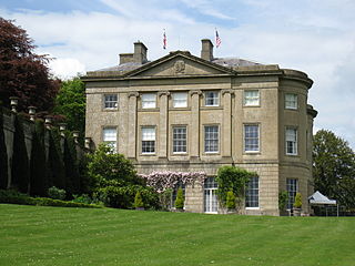
The American Museum and Gardens is a museum of American art and culture based at Claverton, near Bath, England. Its world-renowned collections of American furniture, quilts and folk art are displayed in a Grade I listed 19th-century house, surrounded by gardens overlooking the valley of the River Avon.

<span class="mw-page-title-main">River Avon, Warwickshire</span> River in central England

The River Avon in central England flows generally southwestwards and is a major left-bank tributary of the River Severn, of which it is the easternmost. It is also known as the Warwickshire Avon or Shakespeare's Avon, to distinguish it from several other rivers of the same name in the United Kingdom.

<span class="mw-page-title-main">River Avon, Bristol</span> River in the south west of England

The River Avon is a river in the southwest of England. To distinguish it from a number of other rivers of the same name, it is often called the Bristol Avon. The name 'Avon' is a cognate of the Welsh word afon, meaning 'river'.

<span class="mw-page-title-main">Kennet and Avon Canal</span> Canal in southern England

The Kennet and Avon Canal is a waterway in southern England with an overall length of 87 miles (140 km), made up of two lengths of navigable river linked by a canal. The name is used to refer to the entire length of the navigation rather than solely to the central canal section. From Bristol to Bath the waterway follows the natural course of the River Avon before the canal links it to the River Kennet at Newbury, and from there to Reading on the River Thames. In all, the waterway incorporates 105 locks.

<span class="mw-page-title-main">Bath and North East Somerset</span> Non-metropolitan district in England

Bath and North East Somerset (B&NES) is a unitary authority district in England. Bath and North East Somerset Council was created on 1 April 1996 following the abolition of the county of Avon. It is part of the ceremonial county of Somerset.

<span class="mw-page-title-main">Keynsham</span> Town and civil parish in Somerset, England

Keynsham is a town and civil parish located between Bristol and Bath in Somerset, England. It has a population of 19,000. It was listed in the Domesday Book as Cainesham, which is believed to mean the home of Saint Keyne.

<span class="mw-page-title-main">Roman Baths (Bath)</span> Roman site in the city of Bath, England

The Roman Baths are well-preserved thermae in the city of Bath, Somerset, England. A temple was constructed on the site between 60 and 70 AD in the first few decades of Roman Britain. Its presence led to the development of the small Roman urban settlement known as Aquae Sulis around the site. The Roman baths—designed for public bathing—were used until the end of Roman rule in Britain in the 5th century AD. According to the Anglo-Saxon Chronicle, the original Roman baths were in ruins a century later. The area around the natural springs was redeveloped several times during the Early and Late Middle Ages.

<span class="mw-page-title-main">Thermae Bath Spa</span> Commercial spa in Bath, Somerset

Thermae Bath Spa is a combination of the historic spa and a contemporary building in the city of Bath, England, and reopened in 2006. Bath and North East Somerset council own the buildings, and, as decreed in a Royal Charter of 1590, are the guardians of the spring waters, which are the only naturally hot, mineral-rich waters in the UK. The Spa is operated by YTL Hotels.

<span class="mw-page-title-main">Claverton Pumping Station</span> Pumping station in Somerset, England

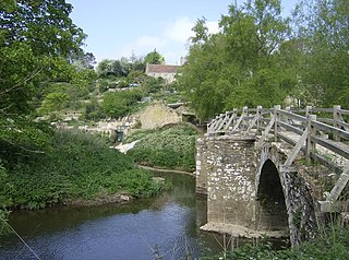
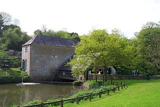
Claverton Pumping Station in the village of Claverton, in the English county of Somerset, pumps water from the River Avon to the Kennet and Avon Canal using power from the flow of the river. It is a Grade I listed building, having been upgraded from Grade II in 2019.

<span class="mw-page-title-main">Bath stone</span> Oolitic limestone from Somerset used as a building material

Bath Stone is an oolitic limestone comprising granular fragments of calcium carbonate. Originally obtained from the Combe Down and Bathampton Down Mines under Combe Down, Somerset, England. Its honey colouring gives the World Heritage City of Bath, England its distinctive appearance. An important feature of Bath Stone is that it is a 'freestone', so-called because it can be sawn or 'squared up' in any direction, unlike other rocks such as slate, which form distinct layers.

<span class="mw-page-title-main">Bathford</span> Human settlement in England

Bathford is a village and civil parish 3 miles (4.8 km) east of Bath, England. The parish, which includes Warleigh, has a population of 1,759 and extends over 1,800 acres (7.3 km2).

<span class="mw-page-title-main">River Frome, Somerset</span> River in Somerset, England

The River Frome is a river in Somerset, England. It rises near Bungalow Farm on Cannwood Lane, south-west of Witham Friary, flows north through Blatchbridge to the town of Frome, and continues in a generally northerly direction passing between the eastern edge of the Mendip Hills and Trowbridge before joining the Bristol Avon at Freshford, below Bradford on Avon.

<span class="mw-page-title-main">Claverton, Somerset</span> Human settlement in England

Claverton is a small village and civil parish about 2 miles (3 km) east of Bath at the southern end of the Cotswolds Area of Outstanding Natural Beauty, in Somerset, England. The parish has a population of 115.

Wessex Water Services Limited, known as Wessex Water, is a water supply and sewerage utility company serving an area of South West England, covering 10,000 square kilometres including Bristol, most of Dorset, Somerset and Wiltshire and parts of Gloucestershire and Hampshire. Wessex Water supplies 1.3 million people with around 285 million litres of water a day.
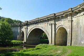
<span class="mw-page-title-main">Dundas Aqueduct</span> Bridge in Limpley Stoke

Dundas Aqueduct carries the Kennet and Avon Canal over the River Avon and the Wessex Main Line railway from Bath to Westbury. The aqueduct is near Monkton Combe, Somerset, and is about 2+12 miles (4 km) southeast of the city of Bath.

<span class="mw-page-title-main">Bathampton Down</span> Limestone plateau in Somerset, England

Bathampton Down is a flat limestone plateau in Bathampton, Somerset, England, overlooking the River Avon and the city of Bath. There is evidence of man's activity at the site since the Mesolithic period including Bathampton Camp, an Iron Age hillfort or stock enclosure. It has also been used for quarrying, and part of it is now a golf course.

<span class="mw-page-title-main">Cleveland Pools</span> Oldest public outdoor swimming pool in England

Cleveland Pools located in Hampton Row, Bath, Somerset, England is a semi-circular lido built to designs by John Pinch the Elder in 1815. It is believed to be the oldest public outdoor swimming pool in England. It is a Grade II* listed building.

John Blackwell was an English civil engineer, known for his work as superintending engineer of the Kennet and Avon Canal under John Rennie and later as the canal company's resident engineer.

References

  1. Danks, Warwick (2003). Claverton Pumping Station (A Definitive Study). Kennet & Avon Canal Trust. ISBN   978-0-9501173-4-8.
  2. Brinsford, James (14 July 2018). "Why beauty spot near Bath is hailed as UK's best swimming location". somersetlive. Retrieved 3 June 2019.
  3. "Posing for the camera at Warleigh Weir, c.1930s". www.bathintime.co.uk. Retrieved 3 June 2019.
  4. "About the Warleigh Weir Project" . Retrieved 6 September 2020.
  5. "Countryside and Rights of Way Act 2000" . Retrieved 6 September 2020.
  6. https://www.gov.uk/government/publications/staying-safe-around-water%7Ctitle=Staying safe around water|publisher=Environment Agency|year=2013
  7. "Weil's disease warning for River Cam - Cambridgeshire Live". 17 July 2018.
  8. "Safety - Staying safe at the weir". Warleigh Weir Project. 2019. Retrieved 5 August 2019.
  9. "Home – Portfolio button nav" . Retrieved 3 June 2019.
  10. "WARLEIGH ISLAND CONSERVATION PROJECT Ltd filing history - Find and update company information - GOV.UK".
  11. "Project & Values" . Retrieved 3 June 2019.
  12. "One man's fight to get bathing water status for a stretch of river near Bath". TheGuardian.com . July 2020.
  13. "Could popular wild swimming spot near Bath get bathing water status?". 30 July 2020.
  14. "Yorkshire swimming spot to get bathing water status in UK first". TheGuardian.com . 22 December 2020.
  15. "Sewage hits dozens of beaches in England and Wales after heavy rain". BBC News. BBC. Retrieved 17 August 2022.
  16. "Warleigh Weir landowner warns beauty spot could be closed if litter nightmare is not solved". Somerset Live. Local World. 29 June 2018. Retrieved 5 August 2019.
  17. "Warleigh Weir users given closure warning". Wiltshire Times. Newsquest Media Group Ltd. 28 June 2018. Retrieved 5 August 2019.
  18. "Public rights of way, Bath and North East Somerset" . Retrieved 6 September 2019.
  19. "Bathing spot closed down due to lockdown rule-breakers". 26 April 2020.
  20. "Weir owner's warning after body found at beauty spot". 11 November 2020.

Coordinates: 51°22′37″N2°18′01″W / 51.3769°N 2.3003°W / 51.3769; -2.3003