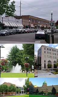
Cedar Hills is a census-designated place and neighborhood in Washington County, Oregon, United States south of U.S. Route 26 and west of Oregon Route 217 and within the Portland metropolitan area. Constructed starting in 1946, Cedar Hills was the largest single housing tract development in the western United States at the time of its completion in 1961.

MAX Light Rail is a light rail system in Portland, Oregon, United States, that is owned and operated by TriMet. Consisting of five lines over a 60.2-mile (96.9 km) network, it serves 97 stations, connecting the North, Northeast, and Southeast sections of Portland; the suburban communities of Beaverton, Clackamas, Gresham, Hillsboro, and Milwaukie; and Portland International Airport to Portland City Center. With an average daily ridership of 121,100 and just under 39 million annual riders in 2018, MAX is the fourth-busiest light rail system in the United States after comparable light rail services in Los Angeles, Boston, and San Francisco. Lines run on all days of the week with frequent headways of 15 minutes to as short as five minutes during rush hour.

The MAX Blue Line is a light rail service that is part of the MAX Light Rail system in Portland, Oregon, United States. The line, the longest in the system, is owned and operated by TriMet; it travels mainly east–west for 32.7 miles (52.6 km) in the cities of Hillsboro, Beaverton, Portland, and Gresham, serving 51 stations between Hatfield Government Center and Cleveland Avenue. The line is the busiest of the five MAX lines, carrying an average 55,370 riders per day on weekdays in September 2018. It runs for 22½ hours per day from Monday to Thursday, with headways of between fifteen minutes off-peak and five minutes during rush hour. Service runs later in the evening on Fridays and Saturdays, and ends earlier on Sundays. The Blue Line shares its route with the Red Line on the west side, between Beaverton Transit Center and Rose Quarter Transit Center. On the east side, it shares tracks with both the Red Line and the Green Line between Rose Quarter Transit Center and Gateway/Northeast 99th Avenue Transit Center.

The MAX Red Line is a light rail service in Portland, Oregon, United States, operated by TriMet as part of the MAX Light Rail system. It serves 29 stations in the cities of Beaverton and Portland, running predominantly east–west. An airport rail link, the line connects central Beaverton, Portland City Center, Northeast Portland, and Portland International Airport. From Beaverton Transit Center to Gateway/Northeast 99th Avenue Transit Center, the Red Line shares all and part of its route with the Blue Line and the Green Line, respectively; it then splits to the exclusive, 5.5-mile (8.9 km) Airport MAX segment to Portland International Airport station. The line runs for 22 hours per day on a headway of at least fifteen minutes daily. It is the second-busiest service in the MAX system, carrying an average of 22,770 weekday passengers in September 2018.
The Gresham Central Transit Center, also known as Gresham Transit Center, is a TriMet transit center and MAX light rail station in Gresham, Oregon, United States. The center is a connection point for several bus routes and the MAX Blue Line. The light rail station is the 25th stop eastbound on the eastside MAX line, which was the Portland metropolitan area's first light rail line.

The Sunset Transit Center is a TriMet bus transit center and light rail station on the MAX Blue and Red lines in Washington County, Oregon. It opened for MAX in 1998 and is the 5th stop westbound on the Westside MAX. This is the first stop after the Robertson Tunnel under Portland's West Hills. Sunset TC is the second-busiest station on the Westside MAX line, with a weekday average of almost 6,000 daily riders in 2012. Though the station has a Portland address, it primarily serves residents of the communities of Cedar Hills, Cedar Mill, and Beaverton.

The Beaverton Transit Center is a transport hub located in Beaverton, Oregon, United States. Owned and operated by TriMet, it is a bus, commuter rail, and light rail station. The transit center is the 15th westbound stop of the MAX Blue Line, the western terminus of the MAX Red Line, and the northern terminus of WES Commuter Rail. It is also a hub for numerous bus lines serving the westside communities of the Portland metropolitan area and is connected by walkway to an adjacent shopping center. The transit center recorded 9,709 average weekday boardings in fall 2018, making it TriMet's busiest.

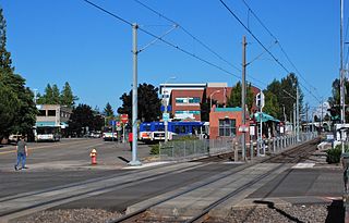
Merlo Road/Southwest 158th Avenue is a light rail station on the MAX Blue Line in Beaverton, Oregon, United States. It is the 10th stop westbound on the Westside MAX.

The Tualatin Valley Highway No. 29 is an Oregon highway which passes through the Tualatin Valley, between the cities of McMinnville and Beaverton. Between McMinnville and Forest Grove, the highway is signed as Oregon Route 47; between Forest Grove and Beaverton it is signed as Oregon Route 8. Oregon 8 becomes Canyon Road in Beaverton east of Hocken Road.

South Metro Area Regional Transit (SMART) is a public transit system operated by the city government of Wilsonville, Oregon, United States. The system currently consists of seven routes and is funded by local businesses. It was created when Wilsonville petitioned to withdraw from the TriMet service district in the late 1980s. Offices of the agency are in the former city hall off Wilsonville Road.

WES Commuter Rail is a commuter rail line in Washington County, Oregon, United States, in the Portland metropolitan area. It is owned by TriMet and operated by Portland and Western Railroad (P&W). It serves five stations in the cities of Beaverton, Tigard, Tualatin, and Wilsonville. The line spans 14.7 miles (23.7 km), traveling north–south along the west side of Oregon Highway 217 and Interstate 5 between Beaverton Transit Center and Wilsonville station. WES connects suburban commuters to MAX Light Rail, running on a 30-minute headway on weekdays during morning and evening rush hours. In May 2018, it carried an average 1,590 riders.

Wilsonville station is a train station and transit center on the Westside Express Service (WES) commuter rail line in Wilsonville, Oregon, United States. The station is the southern terminus of the 14.7-mile (23.7 km) line that connects to the city of Beaverton at the Beaverton Transit Center, where passengers can connect to MAX Light Rail. Opened in January 2009, the station includes a 400-car park-and-ride lot and bus transit center, both owned by the city of Wilsonville as part of its South Metro Area Regional Transit (SMART) public mass transit bus system.

Tigard Transit Center is a bus transfer center and train station in Tigard, Oregon, United States. Operated by regional public transit authority TriMet, the facility opened in 1988 as a bus transit center, and a station for service from the Westside Express Service (WES) commuter rail line was added in 2009. The station is the middle stop of the five-station line.

Tualatin is a commuter rail station in Tualatin, Oregon, United States. Situated between Wilsonville station and Tigard Transit Center on Southwest Boones Ferry Road, it is the second of five stops northbound of TriMet's Westside Express Service line, which links the cities of Beaverton, Tigard, Tualatin, and Wilsonville and provides a connection to MAX Light Rail at Beaverton Transit Center.

Hall/Nimbus station is a train and bus station on the Westside Express Service (WES) commuter rail line in Beaverton, Oregon, United States. The station is the second southbound stop of the five station, 14.7-mile (23.7 km) line that runs from Beaverton in the north to Wilsonville on the south in the Portland metropolitan area. At the northern terminus at the Beaverton Transit Center, passengers can connect to MAX Light Rail. Opened in January 2009, the TriMet-owned station includes a 50-car park-and-ride lot and is located near Washington Square along Oregon Route 217.

Cornell Road is an east–west street and traffic corridor in the Portland metropolitan area, in Multnomah and Washington counties in the U.S. state of Oregon. It crosses the Tualatin Mountains between the Willamette Valley and the city of Portland on the east and the Tualatin Valley and the city of Hillsboro on the west.