TriMet transit centers are defined by TriMet as "major transit hub[s] served by several bus or rail lines". [1] These transit centers are often key areas for accessing public transportation throughout the extended Portland metropolitan area.
| Name | City or community | Location | Year opened | Year closed or delisted as a TC | Image |
|---|---|---|---|---|---|
| Beaverton Transit Center (first location) | Beaverton | unnamed street south of Broadway and west of Lombard in central Beaverton | 1979 [5] | 1988 |  |
| Burlingame Transit Center | Portland | SW Bertha Blvd. and Barbur Blvd. [6] [7] | 1984 | 2001 | |
| Cedar Hills Transit Center | Cedar Hills | SW Wilshire Street east of Marlow Street [8] (behind Cedar Hills Shopping Center) | 1979 [5] | 1998 |  |
| Clackamas Town Center Transit Center (first location) | Clackamas | SE Monterrey Avenue, [9] north side of Clackamas Town Center mall [10] | 1981 | 2006 |  |
| Hillsboro Transit Center (first location) | Hillsboro | SW Baseline Street east of Dennis Avenue [11] | 1988 [12] | 1996 |  |
| Milwaukie Transit Center | Milwaukie | Jackson Street and 21st Avenue [9] [13] | 1981 [14] | 2010 | |
| Rockwood Transit Center | Gresham | SE 188th Avenue between Burnside Street and Stark Street, [15] at Rockwood/E 188th Ave. MAX station | 1986 | 2010 |  |
Note: Rose Quarter Transit Center was originally named Coliseum Transit Center. It was renamed in 1994, but the location remained the same, and the facilities did not change at that time.

MAX Light Rail is a light rail system in Portland, Oregon, United States. Owned and operated by TriMet, it consists of five lines serving a 94-station, 59.7-mile (96.1 km) network. MAX connects Portland City Center with all six sections of Portland; the communities of Beaverton, Clackamas, Gresham, Hillsboro, and Milwaukie; and Portland International Airport. In 2019, it had an average daily ridership of 120,900 and 38.8 million annually. Due to the COVID-19 pandemic, which impacted public transit use globally, annual ridership plummeted to 14.8 million in 2021. Lines run seven days a week with headways of between 30 minutes off-peak and three minutes during rush hours.

Milwaukie is a city mostly in Clackamas County, Oregon, United States; a very small portion of the city extends into Multnomah County. The population was 20,291 at the 2010 census. Founded in 1847 on the banks of the Willamette River, the city, known as the Dogwood City of the West, was incorporated in 1903 and is the birthplace of the Bing cherry. The city is now a suburb of Portland and also adjoins the unincorporated areas of Clackamas and Oak Grove.
TriMet, formally known as the Tri-County Metropolitan Transportation District of Oregon, is a public agency that operates mass transit in a region that spans most of the Portland metropolitan area in the U.S. state of Oregon. Created in 1969 by the Oregon legislature, the district replaced five private bus companies that operated in the three counties: Multnomah, Washington, and Clackamas. TriMet started operating a light rail system, MAX, in 1986, which has since been expanded to five lines that now cover 59.7 miles (96.1 km), as well as the WES Commuter Rail line in 2009. It also provides the operators and maintenance personnel for the city of Portland-owned Portland Streetcar system.

The MAX Blue Line is a light rail service in Portland, Oregon, United States, operated by TriMet as part of the MAX Light Rail system. The longest line in the network, it travels mainly east–west for approximately 33 miles (53 km) between Hillsboro, Beaverton, Portland, and Gresham, serving 48 stations between Hatfield Government Center and Cleveland Avenue. The line is the busiest of the five MAX lines, carrying an average 55,370 riders daily on weekdays in September 2018. It runs for 221⁄2 hours per day from Monday to Thursday, with headways of between 30 minutes off-peak and five minutes during rush hour. Service runs later in the evening on Fridays and Saturdays and ends earlier on Sundays.

The MAX Red Line is a light rail service in Portland, Oregon, United States, operated by TriMet as part of the MAX Light Rail system. It serves 26 stations between Beaverton and Portland and runs predominantly east–west. An airport rail link, the line connects central Beaverton, Portland City Center, and Northeast Portland to Portland International Airport. From Beaverton Transit Center to Gateway/Northeast 99th Avenue Transit Center, the Red Line shares its route with the Blue Line and partially with the Green Line; it then splits to a 5.5-mile (8.9 km) segment to Portland International Airport station referred to as the Airport MAX. Service runs for 22 hours per day with a headway of 15 minutes during most of the day. It is the second-busiest service in the MAX system; it carried an average of 22,530 passengers per weekday in September 2019.

The MAX Yellow Line is a light rail service in Portland, Oregon, United States, operated by TriMet as part of the MAX Light Rail system. It connects North Portland to Portland City Center and Portland State University (PSU) with 17 stops from Expo Center station to PSU South/Southwest 6th and College station. The line travels a route from Portland Expo Center in the north, south to the Rose Quarter through a 5.8-mile (9.3 km) light rail segment along the median of Interstate Avenue called the Interstate MAX. From the Rose Quarter, it crosses the Willamette River via the Steel Bridge and enters downtown Portland, where it operates as a northbound-only service of the Portland Transit Mall on 6th Avenue. Service runs for approximately 21 hours daily with a headway of 15 minutes during most of the day.

Like transportation in the rest of the United States, the primary mode of local transportation in Portland, Oregon is the automobile. Metro, the metropolitan area's regional government, has a regional master plan in which transit-oriented development plays a major role. This approach, part of the new urbanism, promotes mixed-use and high-density development around light rail stops and transit centers, and the investment of the metropolitan area's share of federal tax dollars into multiple modes of transportation. In the United States, this focus is atypical in an era when automobile use led many areas to neglect their core cities in favor of development along interstate highways, in suburbs, and satellite cities.
Portland is "an international pioneer in transit orientated developments."
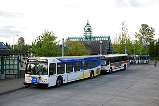
Beaverton Transit Center is a transport hub located in Beaverton, Oregon, United States. Owned and operated by TriMet, it is a bus, commuter rail, and light rail station. The transit center is MAX Light Rail's 15th station eastbound on the Blue Line and western terminus on the Red Line. It is also the northern terminus of WES Commuter Rail and a hub for bus routes mostly serving the westside communities of the Portland metropolitan area. Beaverton Transit Center is situated on Southwest Lombard Avenue, just north of Southwest Canyon Road in central Beaverton, connected by walkway to Canyon Place Shopping Center. It recorded 9,709 average weekday boardings for all modes in fall 2018, making it TriMet's busiest transit center.

Hillsboro Central/Southeast 3rd Avenue Transit Center, also known as Hillsboro Transit Center, is a light rail station and transit center on the MAX Blue Line in Hillsboro, Oregon. Opened in 1998, the red-brick station is the 19th stop westbound on the Westside MAX, one stop from the western terminus of the line. Physically the largest station on the line, it is located at a former stop of the Oregon Electric Railway and includes artwork honoring the history of the community.
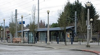
Willow Creek/Southwest 185th Avenue Transit Center is a transport hub in Hillsboro, Oregon, United States. Owned and operated by TriMet, it is a light rail and bus station. The transit center is the ninth station eastbound on the Blue Line and a hub for bus routes mostly serving Washington County in the Portland metropolitan area. It is located by the intersection of Southwest Baseline Road and 185th Avenue near the city's boundary with Beaverton. Opened in 1998, the station was originally conceived as the western terminus of the Westside MAX, but the line was extended further west into Hillsboro, due to population growth occurring at the time the line was being planned. Artwork at the stop represents a reading motif, as a library was planned for the station, but never built. Willow Creek is near the Oregon National Primate Research Center and the rest of the Oregon Health & Science University's West Campus in the Tanasbourne neighborhood.
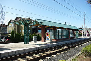
Orenco is a light rail station in Hillsboro, Oregon, United States, served by TriMet as part of the MAX Light Rail system. Situated between the Quatama and Hawthorn Farm stations, it is the seventh station eastbound on the Blue Line. The two-track, island platform station serves the Orenco Station neighborhood, which is considered a model for smart growth and transit-oriented development, and Intel's Ronler Acres campus. An Oregon Electric Railway (OE) depot of the same name served the area in the early 20th century. The TriMet station was built as part of the Westside MAX project, which extended MAX from downtown Portland to downtown Hillsboro. In 2017, TriMet simplified the station's name from "Orenco/Northwest 231st Avenue" after the city renamed Northwest 231st Avenue to Northeast Century Boulevard. The station includes a 125-space park and ride and a bike and ride. It connects to TriMet bus route 47–Baseline/Evergreen and Ride Connection's North Hillsboro Link.

Clackamas Town Center is a shopping mall established in 1981 in the Portland, Oregon, metropolitan area, located on unincorporated land in the Clackamas area of Clackamas County, in the U.S. state of Oregon. It is managed and co-owned by Brookfield Properties Retail Group and is currently anchored by JCPenney, Dick's Sporting Goods, Macy's and a separate Macy's Home/Backstage store. It also includes a 20-screen Century movie theater.
The South Clackamas Transportation District (SCTD) is a bus service that provides public transportation in Molalla, Oregon, connecting that city to Clackamas Community College in Oregon City, and Canby. The cost to ride to or from CCC is only $1 USD; rides to or from Canby used to be free, but now also cost $1 USD.

The MAX Green Line is a light rail service in Portland, Oregon, United States, operated by TriMet as part of the MAX Light Rail system. It is 15 miles (24.1 km) long and serves 30 stations from the PSU South stations to Clackamas Town Center Transit Center, connecting Portland State University (PSU), Portland City Center, Northeast Portland, Southeast Portland, and Clackamas. The Green Line is the only service that shares parts of its route with the four other MAX services, sharing the Portland Transit Mall with the Orange and Yellow lines and the Banfield segment of the Eastside MAX with the Blue and Red lines. Southbound from Gateway/Northeast 99th Avenue Transit Center, it operates the Interstate 205 (I-205) segment through to Clackamas Town Center. Service runs for approximately 211⁄2 hours daily with a headway of 15 minutes during most of the day. It is the third-busiest line in the system, carrying an average of 19,160 riders per day on weekdays in September 2019.
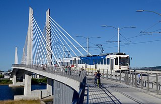
The MAX Orange Line is a light rail service in Portland, Oregon, United States, operated by TriMet as part of the MAX Light Rail system. It connects Portland City Center to Portland State University (PSU), Southeast Portland, Milwaukie, and Oak Grove. The Orange Line starts near Portland Union Station heading southbound within downtown Portland along the Portland Transit Mall on 5th Avenue. From the transit mall, it continues along a 7.3-mile (11.7 km) segment, which runs through the South Waterfront, across the Willamette River into Southeast Portland, then south to Oak Grove, just outside Milwaukie proper in unincorporated Clackamas County. The Orange Line serves 17 stations from Union Station/Northwest 5th & Glisan to Southeast Park Avenue and runs for 201⁄2 hours daily with a minimum headway of 15 minutes during most of the day. The line carried an average of 3,480 daily weekday riders in September 2020.

WES Commuter Rail is a commuter rail line serving part of the Portland metropolitan area's Washington County in the U.S. state of Oregon. Owned by TriMet and operated by Portland & Western Railroad (P&W), the line is 14.7 miles (23.7 km) long and consists of five stations. WES travels north–south just west of Oregon Highway 217 and Interstate 5 (I-5) between the cities of Beaverton, Tigard, Tualatin, and Wilsonville. It connects with MAX Light Rail at Beaverton Transit Center. Service operates on a 30-minute headway on weekdays during the morning and evening rush hours. It carried an average of 1,590 passengers in May 2018.

The Clackamas Town Center Transit Center is a bus transit center and MAX Light Rail station on the MAX Green Line, located in Clackamas County, Oregon, in the southeastern part of the Portland metropolitan area. It is the southern terminus for the I-205 MAX branch.
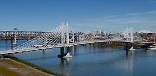
Tilikum Crossing, Bridge of the People is a cable-stayed bridge across the Willamette River in Portland, Oregon, United States. It was designed by TriMet, the Portland metropolitan area's regional transit authority, for its MAX Orange Line light rail passenger trains. The bridge also serves city buses and the Portland Streetcar, as well as bicycles, pedestrians, and emergency vehicles. Private cars and trucks are not permitted on the bridge. It is the first major bridge in the U.S. that was designed to allow access to transit vehicles, cyclists and pedestrians but not cars.

Southeast Bybee Boulevard is a light rail station in Portland, Oregon, United States, served by TriMet as part of the MAX Light Rail system. Situated between the Southeast Tacoma/Johnson Creek and Southeast 17th Avenue and Holgate Boulevard stations, it is the 14th station southbound on the Orange Line, which runs between downtown Portland, Southeast Portland, and Milwaukie. The station's entrances are located on the Bybee Bridge, which spans Southeast McLoughlin Boulevard, the light rail tracks, and Union Pacific Railroad (UP) freight tracks to connect Portland's Sellwood-Moreland and Eastmoreland neighborhoods. The grade-separated island platform station adjoins Eastmoreland Golf Course and Crystal Springs Rhododendron Garden to the east and Westmoreland's park of the same name to the west.

Cornell Road is an east–west street and traffic corridor in the Portland metropolitan area, in Multnomah and Washington counties in the U.S. state of Oregon. It crosses the Tualatin Mountains between the Willamette Valley and the city of Portland on the east and the Tualatin Valley and the city of Hillsboro on the west.