
Hood River County is one of the 36 counties in the U.S. state of Oregon. As of the 2020 census, the population was 23,977. The county seat is Hood River. The county was established in 1908 and is named for the Hood River, a tributary of the Columbia River. Hood River County comprises the Hood River, OR Micropolitan Statistical Area. The Hood River Valley produces apples, pears, and cherries. Situated between Mount Hood and the Columbia River in the middle of the Columbia River Gorge, Hood River County is a popular destination for outdoor enthusiasts, such as windsurfers, mountain-bikers, skiers, hikers, kayakers, and many more.

Canby is a city in Clackamas County, Oregon, United States. The population was 18,171 at the 2020 census. It is along Oregon Route 99E, 2 miles (3 km) northeast of Barlow.

Cascade Locks is a city in Hood River County, Oregon, United States. The city got its name from a set of locks built to improve navigation past the Cascades Rapids of the Columbia River. The U.S. federal government approved the plan for the locks in 1875, construction began in 1878, and the locks were completed on November 5, 1896. The locks were subsequently submerged in 1938, replaced by Bonneville Lock and Dam, although the city did not lose land from the expansion of Lake Bonneville behind the dam some 4 miles (6 km) downstream of the city. The city population was 1,144 at the 2010 census.
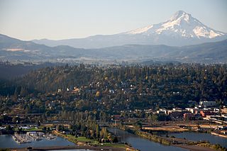
The city of Hood River is the seat of Hood River County, Oregon, United States. It is a port on the Columbia River, and is named for the nearby Hood River. As of the 2020 census, the city population was 8,313. It is the only city in Oregon where public consumption of alcohol on sidewalks or parks is totally unrestricted.

Troutdale is a city in Multnomah County, Oregon, United States, immediately north of Gresham and east of Wood Village. As of the 2020 census, the city population was 16,300. The city serves as the western gateway to the Historic Columbia River Highway, the Mount Hood Scenic Byway, and the Columbia River Gorge. It is approximately 12 miles (19 km) east of Portland.
The Tri-County Metropolitan Transportation District of Oregon (TriMet) is a public agency that operates mass transit in a region that spans most of the Portland metropolitan area in the U.S. state of Oregon. Created in 1969 by the Oregon legislature, the district replaced five private bus companies that operated in the three counties: Multnomah, Washington, and Clackamas. TriMet started operating a light rail system, MAX, in 1986, which has since been expanded to five lines that now cover 59.7 miles (96.1 km), as well as the WES Commuter Rail line in 2009. It also provides the operators and maintenance personnel for the city of Portland-owned Portland Streetcar system. In 2022, the system had a ridership of 53,889,500, or about 189,200 per weekday as of the second quarter of 2023.

Sandy Area Metro is a public transit system operated by the city government of Sandy, Oregon. SAM was created after the city successfully petitioned to be removed from the TriMet district in the late 1990s. The name was chosen in July 1999, and service began operating on January 4, 2000. The local transit provider gave its one-millionth ride on November 21, 2006 and began its twentieth year in January 2019. SAM maintains three routes, a dial-a-ride service called Sandy Transit Area Rides (STAR), and an Elderly and Disabled (ED) medical rides program.

C-Tran, more formally the Clark County Public Transit Benefit Area Authority, is a public transit agency serving Clark County, Washington, United States, including the cities of Battle Ground, Camas, Vancouver, Washougal, and Yacolt. Founded in 1981, C-Tran operates fixed route bus services within Clark County, as well as paratransit services for qualified persons with disabilities (C-Van) and a dial-a-ride service in Camas, Ridgefield, and La Center. C-Tran also provides express commuter services between Clark County and Downtown Portland, Oregon and regional services to the Parkrose/Sumner and Delta Park MAX Light Rail stations, and Oregon Health and Science University. In 2022, the system had a ridership of 4,088,200, or about 15,200 per weekday as of the second quarter of 2023.

Interstate 205 (I-205) is an auxiliary Interstate Highway in the Portland metropolitan area of Oregon and Washington, United States. The north–south freeway serves as a bypass route of I-5 along the east side of Portland, Oregon, and Vancouver, Washington. It intersects several major highways and serves Portland International Airport.

The MAX Blue Line is a light rail service in Portland, Oregon, United States, operated by TriMet as part of the MAX Light Rail system. It travels east–west for approximately 33 miles (53 km)—the longest in the network—between Hillsboro, Beaverton, Portland, and Gresham and serves 48 stations from Hatfield Government Center to Cleveland Avenue. The line carried an average 55,370 riders each day on weekdays in September 2018, the busiest of the five MAX lines. It runs for 221⁄2 hours per day from Monday to Thursday, with headways of between 30 minutes off-peak and five minutes during rush hour. Service runs later in the evening on Fridays and Saturdays and ends earlier on Sundays.

The MAX Red Line is a light rail service in Portland, Oregon, United States, operated by TriMet as part of the MAX Light Rail system. An airport rail link, it connects Beaverton, Portland City Center and Northeast Portland to Portland International Airport. The Red Line serves 26 stations; it interlines with the Blue Line and partially with the Green Line from Beaverton Transit Center to Gateway/Northeast 99th Avenue Transit Center and then branches to the 5.5-mile (8.9 km) Airport MAX segment to Portland Airport station. Its trains run for 22 hours per day with headways of up to 15 minutes. The Red Line carried an average 10,310 passengers per weekday in September 2021, the second-busiest MAX service after the Blue Line.

The MAX Yellow Line is a light rail service in Portland, Oregon, United States, operated by TriMet as part of the MAX Light Rail system. It connects North Portland to Portland City Center and Portland State University (PSU) with 17 stops from Expo Center station to PSU South/Southwest 6th and College station. The line travels from Portland Expo Center in the north, south to the Rose Quarter through a 5.8-mile (9.3 km) light rail segment along the median of Interstate Avenue. From the Rose Quarter, it crosses the Willamette River via the Steel Bridge and enters downtown Portland, where it operates as a northbound-only service of the Portland Transit Mall on 6th Avenue. Service runs for approximately 21 hours daily with a headway of 15 minutes during most of the day.

Like transportation in the rest of the United States, the primary mode of local transportation in Portland, Oregon is the automobile. Metro, the metropolitan area's regional government, has a regional master plan in which transit-oriented development plays a major role. This approach, part of the new urbanism, promotes mixed-use and high-density development around light rail stops and transit centers, and the investment of the metropolitan area's share of federal tax dollars into multiple modes of transportation. In the United States, this focus is atypical in an era when automobile use led many areas to neglect their core cities in favor of development along interstate highways, in suburbs, and satellite cities.
Portland is "an international pioneer in transit orientated developments."
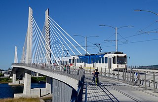
The MAX Orange Line is a light rail service in Portland, Oregon, United States, operated by TriMet as part of the MAX Light Rail system. It connects Portland City Center, Portland State University (PSU), Southeast Portland, Milwaukie, and Oak Grove. The line serves 17 stations from Union Station/Northwest 5th & Glisan to Southeast Park Avenue and runs for 201⁄2 hours daily with a minimum headway of 15 minutes during most of the day. It averaged 3,480 daily weekday riders in September 2020.

The Mount Hood Express is a transit system serving Mount Hood Corridor communities in Clackamas County, Oregon, U.S.
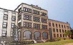
Columbia Gorge Community College is a public community college in The Dalles, Oregon, which is situated and surrounded by the Columbia Gorge National Scenic Area.

Interstate 84 (I-84) in the U.S. state of Oregon is a major Interstate Highway that traverses the state from west to east. It is concurrent with U.S. Route 30 (US 30) for most of its length and runs 376 miles (605 km) from an interchange with I-5 in Portland to the Idaho state line near Ontario. The highway roughly follows the Columbia River and historic Oregon Trail in northeastern Oregon, and is designated as part of Columbia River Highway No. 2 and all of the Old Oregon Trail Highway No. 6; the entire length is also designated as the Vietnam Veterans Memorial Highway. I-84 intersects several of the state's main north–south roads, including US 97, US 197, I-82, and US 395.
Rail transportation is an important element of the transportation network in the U.S. state of Oregon. Rail transportation has existed in Oregon in some form since 1855, and the state was a pioneer in development of electric railway systems. While the automobile has displaced many uses of rail in the state, rail remains a key means of moving passengers and freight, both within the state and to points beyond its borders.
The transportation system of Oregon is a cooperation of complex systems of infrastructure.

Frequent Express (FX) is a high-capacity bus service operated by TriMet in Portland, Oregon, United States. Operating as FX2–Division, the 15-mile (24 km) route runs east–west from 5th & Hoyt on the Portland Transit Mall in downtown Portland to Cleveland Avenue Park and Ride in Gresham via Division Street. It connects Portland City Center, Portland State University (PSU), South Waterfront, Southeast Portland, and central Gresham, with transfers to MAX Light Rail and the Portland Streetcar.