
Sandy is a city located in Clackamas County, Oregon, United States, settled c. 1853 and named after the nearby Sandy River. Located in the foothills of the Cascade Mountain Range, the city serves as the western gateway to the Mount Hood Corridor, and is located approximately 25 miles (40 km) east of Portland.

MAX Light Rail is a light rail system in Portland, Oregon, United States, that is owned and operated by TriMet. Consisting of five lines over a 59.7-mile (96.1 km) network, it serves 97 stations, connecting the North, Northeast, and Southeast sections of Portland; the suburban communities of Beaverton, Clackamas, Gresham, Hillsboro, and Milwaukie; and Portland International Airport to Portland City Center. With an average daily ridership of 120,900 and nearly 39 million annual riders in 2019, MAX is the fourth-busiest light rail system in the United States after comparable light rail services in Los Angeles, Boston, and San Francisco. Lines run on all days of the week with frequent headways of 15 minutes to as short as five minutes during rush hour.
TriMet, more formally known as the Tri-County Metropolitan Transportation District of Oregon, is a public agency that operates mass transit in a region that spans most of the Portland metropolitan area in the U.S. state of Oregon. Created in 1969 by the Oregon legislature, the district replaced five private bus companies that operated in the three counties; Multnomah, Washington, and Clackamas. TriMet started operating a light rail system named MAX in 1986, which has since been expanded to 5 lines that now cover 59.7 miles (96.1 km), as well as a commuter rail line in 2009. It also provides the operators and maintenance personnel for the City of Portland-owned Portland Streetcar system.

C-Tran, more formally the Clark County Public Transit Benefit Area Authority, is a public transit agency serving Clark County, Washington, United States, including the cities of Battle Ground, Camas, Vancouver, Washougal, and Yacolt. Founded in 1981, C-Tran operates fixed route bus services within Clark County, as well as paratransit services for qualified persons with disabilities (C-Van) and a dial-a-ride service in Camas, Ridgefield, and La Center. C-Tran also provides express commuter services between Clark County and various points in Portland, Oregon, including downtown, the Parkrose/Sumner and Delta Park MAX Light Rail stations, Lloyd District, and Oregon Health and Science University.
Fareless Square was an area within central Portland, Oregon, where all rides on TriMet buses and light rail and the Portland Streetcar were free. It primarily consisted of the downtown area and, after 2001, the Lloyd District. It existed from January 1975 through August 2012, but was briefly renamed the Free Rail Zone in January 2010 after its coverage became limited to light rail and streetcar service, with bus rides no longer being free. The TriMet board decided in June 2012 to discontinue the Free Rail Zone primarily to help fill a large shortfall in the agency's budget, and the action was one component of a package of extensive budget cuts which also included service reductions and fare increases. The Free Rail Zone ended on August 31, 2012.

The MAX Blue Line is a light rail service in Portland, Oregon, United States, operated by TriMet as part of the MAX Light Rail system. The longest line in the network, it travels mainly east–west for approximately 33 miles (53 km) in the cities of Hillsboro, Beaverton, Portland, and Gresham, serving 51 stations between Hatfield Government Center and Cleveland Avenue. The line is the busiest of the five MAX lines, carrying an average 55,370 riders per day on weekdays in September 2018. It runs for 221⁄2 hours per day from Monday to Thursday, with headways of between 15 minutes off-peak and five minutes during rush hour. Service runs later in the evening on Fridays and Saturdays and ends earlier on Sundays.

The MAX Red Line is a light rail service in Portland, Oregon, United States, operated by TriMet as part of the MAX Light Rail system. It serves 29 stations in the cities of Beaverton and Portland, running predominantly east–west. An airport rail link, the line connects central Beaverton, Portland City Center, and Northeast Portland to Portland International Airport. From Beaverton Transit Center to Gateway/Northeast 99th Avenue Transit Center, the Red Line shares all and part of its route with the Blue Line and the Green Line, respectively; it then splits to an exclusive, 5.5-mile (8.9 km) segment, referred to as the Airport MAX extension, to Portland International Airport station. Service runs for 22 hours per day on a headway of at least 15 minutes daily. It is the second-busiest service in the MAX system, carrying an average of 22,770 weekday passengers in September 2018.
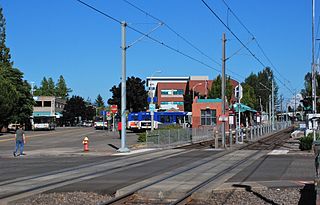
The Gresham Central Transit Center, also known as Gresham Transit Center, is a TriMet transit center and MAX light rail station in Gresham, Oregon, United States. The center is a connection point for several bus routes and the MAX Blue Line. The light rail station is the 25th stop eastbound on the eastside MAX line, which was the Portland metropolitan area's first light rail line.

Like transportation in the rest of the United States, the primary mode of local transportation in Portland, Oregon is the automobile. Metro, the metropolitan area's regional government, has a regional master plan in which transit-oriented development plays a major role. This approach, part of the new urbanism, promotes mixed-use and high-density development around light rail stops and transit centers, and the investment of the metropolitan area's share of federal tax dollars into multiple modes of transportation. In the United States, this focus is atypical in an era when automobile use led many areas to neglect their core cities in favor of development along interstate highways, in suburbs, and satellite cities.

The Sunset Transit Center is a TriMet bus transit center and light rail station on the MAX Blue and Red lines in Washington County, Oregon. It opened for MAX in 1998 and is the 5th stop westbound on the Westside MAX. This is the first stop after the Robertson Tunnel under Portland's West Hills. Sunset TC is the second-busiest station on the Westside MAX line, with a weekday average of almost 6,000 daily riders in 2012. Though the station has a Portland address, it primarily serves residents of the communities of Cedar Hills, Cedar Mill, and Beaverton.

Beaverton Transit Center is a transport hub located in Beaverton, Oregon, United States. Owned and operated by TriMet, it is a bus, commuter rail, and light rail station. The station serves as MAX Light Rail's 14th eastbound stop on the Blue Line and the western terminus of the Red Line. It is also the northern terminus of the Westside Express Service (WES) and a hub for numerous bus routes serving the westside communities of the Portland metropolitan area. The station is situated north of Southwest Canyon Road on Southwest Lombard Avenue in central Beaverton, connected by walkway to Canyon Place Shopping Center. It recorded 9,709 average weekday boardings for all modes in fall 2018, making it TriMet's busiest transit center. Beaverton Transit Center is the second-busiest MAX station after Gateway/Northeast 99th Avenue Transit Center, with 4,554 average daily passengers.

Parkrose/Sumner Transit Center is a TriMet transit center and light rail station on the MAX Red Line in Portland, Oregon. It is the fourth stop north on the Airport MAX branch, and consists of an island platform in the median of Interstate 205. The entrance and exit to the transit center are on Sandy Blvd. near 95th Avenue, in the Parkrose neighborhood and east of the Sumner neighborhood.

South Metro Area Regional Transit (SMART) is a public transit system operated by the city government of Wilsonville, Oregon, United States. The system currently consists of seven routes and is funded by local businesses. It was created when Wilsonville petitioned to withdraw from the TriMet service district in the late 1980s. Offices of the agency are in the former city hall off Wilsonville Road.

WES Commuter Rail is a commuter rail line serving part of Washington County, Oregon, United States, within the Portland metropolitan area. Owned by TriMet and operated by Portland and Western Railroad (P&W), it serves five stations in the cities of Beaverton, Tigard, Tualatin, and Wilsonville. The line spans 14.7 miles (23.7 km), traveling north–south along the west side of Oregon Highway 217 and Interstate 5. It runs on a 30-minute headway on weekdays during the morning and evening rush hours, connecting suburban commuters to MAX Light Rail at Beaverton Transit Center. In May 2018, WES carried an average 1,590 riders.

The Clackamas Town Center Transit Center is a bus transit center and MAX Light Rail station on the MAX Green Line, located in Clackamas County, Oregon, in the southeastern part of the Portland metropolitan area. It is the southern terminus for the I-205 MAX branch.

The Mount Hood Express is a transit system serving Mount Hood Corridor communities in Clackamas County, Oregon, U.S.
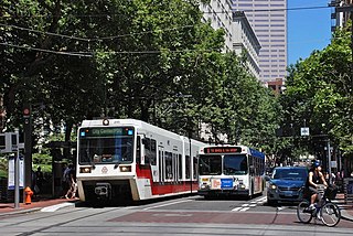
The Portland Transit Mall is a public transit corridor that travels north–south through the center of downtown Portland, Oregon, United States. It encompasses a pair of one-way streets—one for northbound traffic, the other for southbound—along which two of the three lanes are restricted to transit vehicles only. The transit mall opened in 1977 and until light rail trains were added in 2009, buses were the only transit vehicles using it. The mall was rebuilt and extended southwards from 2007 to 2009, and it reopened for buses on May 24, 2009. Light rail service on the mall was introduced on August 30, 2009, with the shifting of the MAX Yellow Line to the mall from its original routing in downtown, and a second MAX line, the Green Line, began serving the mall a month later on September 12. Between fall 2009 and July 2014, the Portland Vintage Trolley also served the transit mall on certain Sundays. Although the mall's stops are mainly served by TriMet vehicles, on weekdays buses on express routes operated by C-Tran and the Columbia County Rider also serve the mall. In September 2015, the new MAX Orange Line replaced the Yellow Line service in the southbound direction on the mall, on 5th Avenue, with the Orange and Yellow lines being through-routed at all times.
The Rose City Transit Company was a private company that operated most mass transit service in the city of Portland, Oregon, from 1956 to 1969. It operated only within the city proper. Transit services connecting downtown Portland with suburbs outside the city but within the Portland metropolitan area were run by other private companies, mainly a consortium of four companies known collectively as the "Blue Bus" lines.

The "Blue Bus" lines was a group of four affiliated privately owned public transportation companies that provided bus transit service in the Portland, Oregon, metropolitan area in the 1950s and 1960s. The name was unofficial but was in common use in the 1960s, and variations included "Blue Bus lines", "Blue Lines", "blue bus" lines and "blue buses". The Blue Bus companies provided service only between Portland and suburbs outside the city, or within such suburbs, as transit service within the city of Portland was the exclusive franchise of the Portland Traction Company or, after 1956, the Rose City Transit Company (RCT). The "blue buses" were prohibited from making stops inside the city except to pick up passengers destined for points outside RCT's service area. The "blue" name was a reference to the paint scheme worn by most buses of the consortium. By contrast, city transit operator Rose City's buses wore a primarily red paint scheme.
The Division Transit Project is a future high-capacity bus route in Portland, Oregon, United States, that will be operated by TriMet. The 15-mile (24 km) line will run from the northern end of the Portland Transit Mall in downtown Portland to Cleveland Park and Ride in Gresham via Southeast Division Street. As of April 2019, the project is scheduled to begin construction in late 2019 and is targeted for completion in 2022.

