
MAX Light Rail is a light rail system in Portland, Oregon, United States, that is owned and operated by TriMet. The system is 59.7 miles (96.1 km) long, consists of 94 stations, and is served by five color-designated lines. It operates in Oregon's Clackamas, Multnomah, and Washington counties, connecting all six sections of Portland; the communities of Beaverton, Clackamas, Gresham, Hillsboro, and Milwaukie; and Portland International Airport to Portland City Center. As of 2018, MAX is the fourth-busiest light rail system in the United States after comparable light rail services in Los Angeles, Boston, and San Francisco. The system had an average daily ridership of 120,900 and nearly 39 million annual riders in 2019. Lines run seven days a week with headways of between 30 minutes off-peak and three minutes during rush hours.

The Transitway is a bus rapid transit (BRT) network operated by OC Transpo in Ottawa, Ontario, Canada. It comprises a series of bus-only roadways and reserved lanes on city streets and highways. The dedicated busways ensure that buses and emergency vehicles on the Transitway rarely intersect directly with the regular traffic, and make it possible for them to continue at full speed even during rush hour. OC Transpo operates a network of rapid routes which use the Transitway to connect communities with the O-Train light rail system. Additional bus routes also use segments of the Transitway.
Interstate 205 (I-205) is an auxiliary Interstate Highway in the Portland metropolitan area of Oregon and Washington. It serves as a bypass route of I-5, traveling north–south along the east side of Portland, Oregon, and Vancouver, Washington, intersecting several major highways and serving Portland International Airport.

The MAX Blue Line is a light rail service in Portland, Oregon, United States, operated by TriMet as part of the MAX Light Rail system. The longest line in the network, it travels mainly east–west for approximately 33 miles (53 km) between Hillsboro, Beaverton, Portland, and Gresham, serving 48 stations between Hatfield Government Center and Cleveland Avenue. The line is the busiest of the five MAX lines, carrying an average 55,370 riders daily on weekdays in September 2018. It runs for 221⁄2 hours per day from Monday to Thursday, with headways of between 30 minutes off-peak and five minutes during rush hour. Service runs later in the evening on Fridays and Saturdays and ends earlier on Sundays.

The MAX Red Line is a light rail service in Portland, Oregon, United States, operated by TriMet as part of the MAX Light Rail system. It serves 26 stations between Beaverton and Portland, running predominantly east–west. An airport rail link, the line connects central Beaverton, Portland City Center, and Northeast Portland to Portland International Airport. From Beaverton Transit Center to Gateway/Northeast 99th Avenue Transit Center, the Red Line shares its route with the Blue Line and partially with the Green Line; it then splits to a 5.5-mile (8.9 km) segment to Portland International Airport station that is referred to as the Airport MAX. Service runs for 22 hours per day on a headway of at least 15 minutes daily. It is the second-busiest service in the MAX system, carrying an average of 22,530 passengers per weekday in September 2019.
The Mount Hood Freeway is a partially constructed but never to be completed freeway alignment of U.S. Route 26 and Interstate 80N, which would have run through southeast Portland, Oregon. Related projects would have continued the route through the neighboring suburb of Gresham, out to the city of Sandy.

The MAX Green Line is a light rail service in Portland, Oregon, United States, operated by TriMet as part of the MAX Light Rail system. The line is 15 miles (24.1 km) long and serves 30 stations between the PSU South stations and Clackamas Town Center Transit Center. It connects Portland State University (PSU), Portland City Center, Northeast Portland, Southeast Portland, and Clackamas. The Green Line is the only service that shares parts of its alignment with the four other MAX services; it shares the Portland Transit Mall with the Orange Line and the Yellow Line, and the Banfield segment of the Eastside MAX with the Blue Line and the Red Line. Southbound from Gateway/Northeast 99th Avenue Transit Center, the Green Line operates the Interstate 205 (I-205) MAX segment through to Clackamas Town Center. Service runs for approximately 211⁄2 hours daily with a headway of 15 minutes during most of the day. It is the third-busiest line in the system, carrying an average of 19,160 riders per day on weekdays in September 2019.
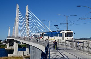
The MAX Orange Line is a light rail service in Portland, Oregon, United States, operated by TriMet as part of the MAX Light Rail system. It connects Portland City Center to Portland State University (PSU), Southeast Portland, Milwaukie, and Oak Grove. The Orange Line starts near Portland Union Station heading southbound within downtown Portland along the Portland Transit Mall on 5th Avenue. From the transit mall, it continues along a 7.3-mile (11.7 km) segment, which runs through the South Waterfront, across the Willamette River into Southeast Portland, then south to Oak Grove, just outside Milwaukie proper in unincorporated Clackamas County. The Orange Line serves 17 stations from Union Station/Northwest 5th & Glisan to Southeast Park Avenue and runs for 201⁄2 hours daily with a minimum headway of 15 minutes during most of the day. The line carried an average of 3,480 daily weekday riders in September 2020.

The Harbor Transitway is a 10.3-mile (16.6 km) shared-use express bus corridor and high occupancy toll (HOT) lanes running in the median of Interstate 110 between Downtown Los Angeles and the Harbor Gateway Transit Center in Gardena, California. Buses also make intermediate stops at 37th Street/USC, Slauson, Manchester, Harbor Freeway, and Rosecrans stations. The facility opened for two-person carpools on June 26, 1996, for buses on August 1, 1996 and was converted to HOT lanes as part of the Metro ExpressLanes project on November 10, 2012.

Vermont Avenue is one of the longest running north/south streets in City of Los Angeles and Los Angeles County, California. With a length of 23.3 miles (37.5 km), is the third longest of the north/south thoroughfares in the region. For most of its length between its southern end in San Pedro and south of Downtown Los Angeles, it runs parallel to the west of the Harbor Freeway (I-110).

The El Monte Busway is a 12-mile (19 km) shared-use express bus corridor (busway) and high occupancy toll (HOT) lanes running along Interstate 10 between Union Station in Downtown Los Angeles and Interstate 605 or El Monte Station in El Monte, California. Buses also make intermediate stops at Cal State LA station and LA County+USC Medical Center station. The busway opened in January 1973 to buses only, three-person carpools were allowed to enter in 1976, and the facility was converted to HOT lanes as part of the Metro ExpressLanes project on February 22, 2013.
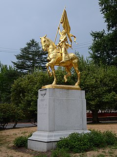
Laurelhurst is a neighborhood of vintage homes and undulating streets surrounding a park of the same name, straddling the NE and SE sections of Portland. Stone markers flank the entrances to the area. The center of the neighborhood, Coe Circle, contains a gilded equestrian statue of Joan of Arc, which is a World War I war memorial. The Laurelhurst Historic District was officially listed in the National Register of Historic Places In 2019.

Harbor Freeway is a transport hub located on the Harbor Transitway, within the Judge Harry Pregerson Interchange of Interstates I-105 and I-110 near Figueroa Street in the neighborhood of South Los Angeles. The station serves the Metro C Line and the Metro J Line and other bus services. The station is owned by Caltrans and operated by the Los Angeles County Metropolitan Transportation Authority.

Harbor Gateway Transit Center is a large bus station at the southern end of the Harbor Transitway that serves as a transport hub for the South Bay region of Los Angeles County including the Harbor Gateway neighborhood of Los Angeles and cities of Carson, Gardena, and Torrance. The station consists of one large island platform with 12 bus bays and a 980 space park and ride parking lot located in the southwest corner of Interstate 110 and California State Route 91.
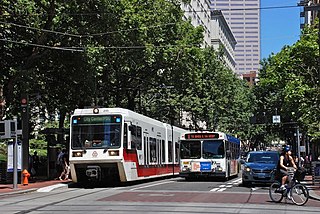
The Portland Transit Mall is a public transit corridor that travels north–south through the center of downtown Portland, Oregon, United States. It encompasses a pair of one-way streets—one for northbound traffic, the other for southbound—along which two of the three lanes are restricted to transit vehicles only. The transit mall opened in 1977 and until light rail trains were added in 2009, buses were the only transit vehicles using it. The mall was rebuilt and extended southwards from 2007 to 2009, and it reopened for buses on May 24, 2009. Light rail service on the mall was introduced on August 30, 2009, with the shifting of the MAX Yellow Line to the mall from its original routing in downtown, and a second MAX line, the Green Line, began serving the mall a month later on September 12. Between fall 2009 and July 2014, the Portland Vintage Trolley also served the transit mall on certain Sundays. Although the mall's stops are mainly served by TriMet vehicles, on weekdays buses on express routes operated by C-Tran and the Columbia County Rider also serve the mall. In September 2015, the new MAX Orange Line replaced the Yellow Line service in the southbound direction on the mall, on 5th Avenue, with the Orange and Yellow lines being through-routed at all times.

The J Line is a 38 mi (61 km) bus rapid transit route that runs between El Monte, Downtown Los Angeles and Gardena, with some trips continuing to San Pedro. It is one of the two lines in the Metro Busway system and is operated by the Los Angeles County Metropolitan Transportation Authority (Metro).

Southeast Holgate Boulevard is a light rail station on the MAX Green Line in Portland, Oregon. It is the 4th stop southbound on the I-205 MAX branch. The station is at the intersection of Interstate 205 and Holgate Boulevard. This station has a center platform, and has a park-and-ride facility on the west side.

Lents Town Center/Southeast Foster Road is a light rail station on the MAX Green Line in Portland, Oregon. It is the 5th stop southbound on the I-205 MAX branch. The station is at the intersection of Interstate 205 and Foster Road. It is located in the Lents neighborhood's town center business district. It also provides access to the Springwater Corridor, which was once a transit line to the suburbs and is now a dedicated bikeway through southeast Portland.

Metro Busway is a system of bus rapid transit (BRT) routes that operate primarily along exclusive or semi-exclusive roadways known locally as a busway or transitway. There are currently two lines in the system, the G Line in the San Fernando Valley, and the J Line between El Monte, Downtown Los Angeles and Gardena, with some trips continuing to San Pedro. The Los Angeles County Metropolitan Transportation Authority (Metro) operates the system.
The history of the Los Angeles Metro Rail and Busway system begins in the early 1970s, when the traffic-choked region began planning a rapid transit system. The first dedicated busway opened along the 10 freeway in 1973, and the region's first light rail line, the Blue Line opened in 1990. Today the system includes over 160 miles (260 km) of heavy rail, light rail, and bus rapid transit lines, with multiple new lines under construction as of 2019.
