Related Research Articles
Wing Rural District was a rural district in the administrative county of Buckinghamshire, England. It was created in 1894 with the name Linslade Rural District, but was renamed Wing Rural District in 1897 when Linslade itself was removed from the district to become an urban district. Wing Rural District was abolished in 1974 to become part of Aylesbury Vale District.
Aylesbury was a rural district in the administrative county of Buckinghamshire, England from 1894 to 1974. It was named after but did not include Aylesbury, which was a separate municipal borough.

Buckingham Rural District was a rural district in the administrative county of Buckinghamshire, England from 1894 to 1974, covering an area in the north-west of the county. It was named after but did not include the borough of Buckingham.
Winslow Rural District was a rural district in the administrative county of Buckinghamshire, England from 1894 to 1974, covering an area in the north of the county.

Potters Bar Urban District was a local government district in England from 1894 to 1974, covering the town of Potters Bar and the village of South Mimms. The district was initially called the South Mimms Rural District, being renamed in 1934.
Wycombe Rural District was, from 1894 to 1974, a rural district in the administrative county of Buckinghamshire, England.
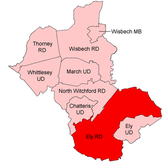
Ely Rural District was a rural district in England from 1894 to 1974. It was named after Ely, but did not include the city itself, instead covering the rural area to the west and north of it. It formed part of the administrative county of the Isle of Ely from 1894 to 1965, when this was merged into Cambridgeshire and Isle of Ely.

Elstree Rural District was a rural district in Hertfordshire, England from 1894 to 1974.

Hadham Rural District was a rural district in Hertfordshire, England from 1894 to 1935, covering an area in the east of the county.

Hambleden Rural District was a rural district in Buckinghamshire, England from 1894 to 1934, covering an area in the south-west of the county.
Hitchin Rural District was a rural district in Hertfordshire, England from 1894 to 1974, covering an area in the north of the county.

Hertford Rural District was a rural district in Hertfordshire, England from 1894 to 1974. It covered the rural area around the county town of Hertford, but did not include the town itself.
St Albans Rural District was a rural district in the administrative county of Hertfordshire, England from 1894 to 1974. It surrounded but did not include the city of St Albans.
Berkhamsted Rural District was a rural district in Hertfordshire, England from 1894 to 1974, covering an area to the west of the county. Until 1937 the official spelling of the district's name was Berkhampstead Rural District.
Welwyn Rural District was a rural district in Hertfordshire, England from 1894 to 1974, covering an area in the centre of the county.
Ware Rural District was a rural district in Hertfordshire, England from 1894 to 1974, covering an area in the east of the county.
Hungerford Rural District was a rural district in Berkshire, England from 1894 to 1974, covering an area in the south-west of the county.
Newbury Rural District was a rural district in Berkshire, England from 1894 to 1974, covering an area in the south-west of the county which almost surrounded but did not include the town of Newbury.
Chipping Norton Rural District was a rural district in Oxfordshire, England from 1894 to 1974. It surrounded but did not include the town of Chipping Norton.
Witney Rural District was a rural district in Oxfordshire, England from 1894 to 1974. It surrounded but did not include the town of Witney.
References
- 1 2 3 "Watford Rural District, A Vision of Britain through Time". GB Historical GIS / University of Portsmouth. Retrieved 26 January 2022.
- ↑ Higginbotham, Peter. "Watford Workhouse". The Workhouse. Retrieved 26 January 2022.
- ↑ Kelly's Directory of Hertfordshire. London. 1902. p. 224.
- ↑ "Rural District Council". Watford Observer. 4 June 1904. p. 3. Retrieved 26 January 2022.
- ↑ "Rural District Council". Watford Observer. 2 July 1904. p. 7. Retrieved 26 January 2022.
- ↑ "The Watford Rural District Council". Watford Observer. 27 April 1901. p. 8. Retrieved 26 January 2022.
- ↑ Watford, Uxbridge and District Telephone Directory. London: Post Office Telephones. 1930. p. 63.
Office address given as both 9 Market Street and 7 Church Street
- ↑ Kelly's Directory of Hertfordshire. London. 1937. p. 287.
Meets at Watford Place, Office address given as both 7 Church Street and 25 King Street.
- ↑ London L–Z Telephone Directory. London: Post Office Telephones. 1932. p. 1764.
- ↑ "Job advertisement". Public Works Weekly Surveyor. 105: 254, 334. 1947. Retrieved 26 January 2022.
25 King Street
- ↑ "The Municipal Year Book and Encyclopaedia of Local Government Administration". Municipal Journal: 1305. 1947. Retrieved 26 January 2022.
Wynyard House
- ↑ "Hertfordshire County Council". The London Gazette (46237): 3427. 15 March 1974. Retrieved 27 January 2022.
- ↑ The English Non-Metropolitan Districts (Definition) Order. London: Her Majesty's Stationery Office. 1972. Retrieved 26 January 2022.