Related Research Articles

The Chicago River is a system of rivers and canals with a combined length of 156 miles (251 km) that runs through the city of Chicago, including its center. Though not especially long, the river is notable because it is one of the reasons for Chicago's geographic importance: the related Chicago Portage is a link between the Great Lakes and the Mississippi River Basin, and ultimately the Gulf of Mexico.

The Illinois River is a principal tributary of the Mississippi River and is approximately 273 miles (439 km) long. Located in the U.S. state of Illinois, the river drains a large section of central Illinois, with a drainage basin of 28,756.6 square miles (74,479 km2). The drainage basin extends into Wisconsin, Indiana, and a very small area of southwestern Michigan.
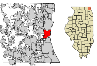
North Chicago is a city in Lake County, Illinois, United States, and a suburb of the Chicago metropolitan area. The population was 32,574 at the 2010 census making it the 2nd largest city by population in the county, after Waukegan.

An endorheic basin is a drainage basin that normally retains water and allows no outflow to other external bodies of water, such as rivers or oceans, but drainage converges instead into lakes or swamps, permanent or seasonal, that equilibrate through evaporation. They are also called closed or terminal basins or internal drainage systems or basins. Endorheic regions contrast with exorheic regions. Endorheic water bodies include some of the largest lakes in the world, such as the Caspian Sea, the world's largest inland body of water.

The Calumet River is a system of heavily industrialized rivers and canals in the region between the south side of Chicago, Illinois, and the city of Gary, Indiana. Historically, the Little Calumet River and the Grand Calumet River were one, the former flowing west from Indiana into Illinois, then turning back east to its mouth at Lake Michigan at Marquette Park in Gary.

The Grand River is a river in the southwestern portion of the southern peninsula of Michigan, United States, that flows into Lake Michigan's southeastern shore. It is the longest river in Michigan, running 252 miles (406 km) from its headwaters in Hillsdale County on the southern border north to Lansing and west to its mouth on the Lake at Grand Haven. Native Americans who lived along the river before the arrival of the French and British called the river O-wash-ta-nong, meaning "Far-away-water'", because of its length.

The Huron River is a 130-mile-long (210 km) river in southeastern Michigan, rising out of the Huron Swamp in Springfield Township in northern Oakland County and flowing into Lake Erie, as it forms the boundary between present-day Wayne and Monroe counties. Thirteen parks, game areas, and recreation areas are associated with the river, which passes through the cities of Dexter, Ann Arbor, Ypsilanti, Belleville, Flat Rock and Rockwood that were developed along its banks.

The Kankakee River is a tributary of the Illinois River, approximately 133 miles (214 km) long, in the Central Corn Belt Plains of northwestern Indiana and northeastern Illinois in the United States. At one time, the river drained one of the largest wetlands in North America and furnished a significant portage between the Great Lakes and the Mississippi River. Significantly altered from its original channel, it flows through a primarily rural farming region of reclaimed cropland, south of Lake Michigan.

The Driftless Area is a region in southwestern Wisconsin, southeastern Minnesota, northeastern Iowa, and the extreme northwestern corner of Illinois, of the American Midwest. The region escaped the flattening effects of glaciation during the last ice age and is consequently characterized by steep, forested ridges, deeply carved river valleys, and karst geology characterized by spring-fed waterfalls and cold-water trout streams. Ecologically, the Driftless Area's flora and fauna are more closely related to those of the Great Lakes region and New England than those of the broader Midwest and central Plains regions. Colloquially, the term includes the incised Paleozoic Plateau of southeastern Minnesota and northeastern Iowa. The region includes elevations ranging from 603 to 1,719 feet at Blue Mound State Park, and covers 24,000 square miles (62,200 km2). The rugged terrain is due both to the lack of glacial deposits, or drift, and to the incision of the upper Mississippi River and its tributaries into bedrock.
The River Rouge is a 127-mile river in the Metro Detroit area of southeastern Michigan. It flows into the Detroit River at Zug Island, which is the boundary between the cities of River Rouge and Detroit.

The Saline River is a tributary of the Ohio River, approximately 27 miles (43 km) long, in the Southern Illinois region of the U.S. state of Illinois. The river drains a large section of southeast Illinois, with a drainage basin of 1,762 square miles (4,564 km2). The major tributaries include the South Fork, Middle Fork and North Fork, all lying within the Saline Valley. The once meandering swampy river was important among Native Americans and early settlers as a source of salt from numerous salt springs where it was commercially extracted in the early 19th century.

Lake Chicago was a prehistoric proglacial lake that is the ancestor of what is now known as Lake Michigan, one of North America's five Great Lakes. Fed by retreating glaciers, it drained south through the Chicago Outlet River.

Wolf Lake is an 804-acre (325.4 ha) lake that straddles the Indiana and Illinois state line near Lake Michigan. It is smaller than it was prior to settlement by European colonizers because of infilling for development around the edges. Despite years of environmental damage caused by heavy industries, transportation infrastructure, urban runoff and filling of wetlands, it is one of the most important biological sites in the Chicago region.
The Skokie River is a 20-mile-long (32 km) river that flows through the northern suburbs of Chicago, Illinois. It flows almost parallel to the shore of Lake Michigan, and historically discharged its outflow into that lake via the Chicago River. However, the construction of the Chicago Sanitary and Ship Canal in 1900 caused the drainage of the Chicago River, including its Skokie River tributary, to flow southwestward towards the Mississippi River.

The geography of Indiana comprises the physical features of the land and relative location of U.S. State of Indiana. Indiana is in the north-central United States and borders on Lake Michigan. Surrounding states are Michigan to the north and northeast, Illinois to the west, Kentucky to the south, and Ohio to the east. The entire southern boundary is the Ohio River.

The Coldwater River is a 19.4-mile-long (31.2 km) stream in the U.S. state of Michigan. Located in western Michigan, the river is a part of the Grand River drainage basin.

The Manistique River is a 71.2-mile-long (114.6 km) river in the U.S. state of Michigan that winds southward through the central Upper Peninsula from its headwaters near Lake Superior to its mouth in Lake Michigan. It drains approximately 1,461 square miles (3,780 km2) of the Upper Peninsula, including most of Schoolcraft County and small portions of Alger County, Delta County, Luce County, and Mackinac County. The river rises at the outlet of Manistique Lake in the southwest corner of Luce County, and after flowing through the Seney National Wildlife Refuge, empties into Lake Michigan at Manistique, Michigan. M-77, a north-south highway, serves much of the Manistique River's drainage and crosses the river and its tributaries several times.

The Kankakee Outwash Plain is a flat plain interspersed with sand dunes in the Kankakee River valley in northwestern Indiana and northeastern Illinois of the United States. It is just south of the Valparaiso Moraine and was formed during the Wisconsin Glaciation. As the glacier, stopped at the Valparaiso Moraine, melted, the meltwater was carried away to the outwash plain. On the south side of the moraine, where the elevation drops, the meltwaters eroded away valleys, carrying sand and mud with them. As the muddy meltwater reached the valley where the slope lessened, the water slowed, depositing the sand on the outwash plain. This created a smooth, flat, and sandy plain. Before its draining, the Kankakee Marsh, located on the outwash plain, was one of the largest freshwater marshes in the United States.

The Grand Calumet River is a 13.0-mile-long (20.9 km) river that flows primarily into Lake Michigan. Originating in Miller Beach in Gary, it flows through the cities of Gary, East Chicago and Hammond, as well as Calumet City and Burnham on the Illinois side. The majority of the river's flow drains into Lake Michigan via the Indiana Harbor and Ship Canal, sending about 1,500 cubic feet (42 m3) per second of water into the lake. A smaller part of the flow, at the river's western end, enters the Calumet River and ultimately drains into the Illinois and ultimately the Mississippi River.

The Pigeon River is a small river flowing to Lake Michigan on the western Lower Peninsula of the U.S. state of Michigan. The river is approximately 12.9 miles (20.8 km) long and drains an area of 61.7 square miles (160 km2) in a generally rural area situated between the cities of Holland and Grand Haven. Via Lake Michigan and the larger Great Lakes system, it is part of the watershed of the St. Lawrence River.
References
- 1 2 "Waukegan County Watershed: Lake County, Illinois" (PDF). Lake County, Illinois . Archived from the original (PDF) on 2016-03-04. Retrieved 2015-05-13.CS1 maint: discouraged parameter (link)
- 1 2 Illinois Atlas and Gazetteer. Freeport, Maine: DeLorme Mapping. 1991. ISBN 0-89933-213-7.
- ↑ U.S. Geological Survey Geographic Names Information System: Waukegan River