
A henge loosely describes one of three related types of Neolithic earthwork. The essential characteristic of all three is that they feature a ring-shaped bank and ditch, with the ditch inside the bank. Because the internal ditches would have served defensive purposes poorly, henges are not considered to have been defensive constructions. The three henge types are as follows, with the figure in brackets being the approximate diameter of the central flat area:
- Henge. The word henge refers to a particular type of earthwork of the Neolithic period, typically consisting of a roughly circular or oval-shaped bank with an internal ditch surrounding a central flat area of more than 20 m (66 ft) in diameter. There is typically little if any evidence of occupation in a henge, although they may contain ritual structures such as stone circles, timber circles and coves. Henge monument is sometimes used as a synonym for henge. Henges sometimes, but by no means always, featured stone or timber circles, and circle henge is sometimes used to describe these structures. The three largest stone circles in Britain are each within a henge. Examples of henges without significant internal monuments are the three henges of Thornborough Henges. Although having given its name to the word henge, Stonehenge is atypical in that the ditch is outside the main earthwork bank.
- Hengiform monument. Like an ordinary henge, except the central flat area is between 5 and 20 m (16–66 ft) in diameter, they comprise a modest earthwork with a fairly wide outer bank. The terms mini-henge or Dorchester henge are sometimes used as synonyms for hengiform monument. An example is the Neolithic site at Wormy Hillock Henge.
- Henge enclosure. A Neolithic ring earthwork with the ditch inside the bank, with the central flat area having abundant evidence of occupation and usually being more than 300 m (980 ft) in diameter. Some true henges are as large as this, but lack evidence of domestic occupation. Super-henge or superhenge is sometimes used as a synonym for a henge enclosure. However, sometimes the term is used to indicate size alone rather than use, e.g. "Marden henge ... is the least understood of the four British 'superhenges' ".

A causewayed enclosure is a type of large prehistoric earthwork common to the early Neolithic in Europe. It is an enclosure marked out by ditches and banks, with a number of causeways crossing the ditches. More than 100 examples are recorded in France and 70 in Southern England and Wales, while further sites are known in Scandinavia, Belgium, Germany, Italy, Ireland and Slovakia.

Durrington Walls is the site of a large Neolithic settlement and later henge enclosure located in the Stonehenge World Heritage Site in England. It lies 2 miles (3.2 km) north-east of Stonehenge in the parish of Durrington, just north of Amesbury in Wiltshire. The henge is the second-largest Late Neolithic palisaded enclosure known in the United Kingdom, after Hindwell in Wales.
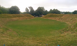
Maumbury Rings is a Neolithic henge in the south of Dorchester town in Dorset, England. It is a large circular earthwork, 85 metres in diameter, with a single bank and an entrance to the north east. It was modified during the Roman period when it was adapted for use as an amphitheatre, and the site was remodelled again during the English Civil War when it was used as an artillery fort guarding the southern approach to Dorchester. The monument is now a public open space, and used for open-air concerts, festivals and re-enactments.
Limbury is a suburb of Luton, in the Luton district, in the ceremonial county of Bedfordshire, England, and was formerly a village before Luton expanded around it. The area is roughly bounded by Bramingham Road to the north, Marsh Road to the south, Bramingham Road to the west, and Catsbrook Road, Runfold Avenue, Grosvenor Road, Bancroft Road and Blundell Road to the east.

Leagrave is a former village and now a suburb of Luton, in the Luton district, in the ceremonial county of Bedfordshire, England, in the northwest of the town. The current council ward is roughly bounded by Vincent Road, Torquay Drive and High Street to the north, Roman Road and Stoneygate Road to the south, the M1 to the west, and Marsh Road and Leagrave Park to the east.

Figsbury Ring is an 11.2 hectare biological Site of Special Scientific Interest in Wiltshire, England, notified in 1975. It is owned and managed by the National Trust.
The prehistory of the County of Norfolk, England is broken into specific time periods, these being Palaeolithic, Mesolithic and Neolithic.

The Bull Ring is a Class II henge that was built in the late Neolithic period near Dove Holes in Derbyshire, England.
Luton is a town located in the south of Bedfordshire, England.

In archaeology, earthworks are artificial changes in land level, typically made from piles of artificially placed or sculpted rocks and soil. Earthworks can themselves be archaeological features, or they can show features beneath the surface.
Black Ditches is an earthwork close to the village of Cavenham of Suffolk, and part of it is a biological Site of Special Scientific Interest (SSSI). The earthwork is 4.5 miles long between the River Lark at Lackford and the Icknield Way. It is described by the Suffolk Historic Environment Record as having no direct dating evidence but "by analogy with other linear earthworks in the region it is usually assumed to be post Roman".

Marden Henge is the largest Neolithic henge enclosure discovered to date in the United Kingdom. The monument is north-east of the village of Marden, Wiltshire, within the Vale of Pewsey and between the World Heritage Sites of Avebury and Stonehenge.

The Devil's Quoits is a henge and stone circle to the south of the village of Stanton Harcourt in Oxfordshire, England. The site is believed to be from the Neolithic Period, between 4000 and 5000 years old, and is a Scheduled Ancient Monument. The Quoits were restored between 2002 and 2008, with stones which had been knocked over or had fallen over being re-erected, and the surrounding earthworks rebuilt.

Scratchbury Camp is the site of an Iron Age univallate hillfort on Scratchbury Hill, overlooking the Wylye valley about 1 km northeast of the village of Norton Bavant in Wiltshire, England. The fort covers an area of 37 acres (15 ha) and occupies the summit of the hill on the edge of Salisbury Plain, with its four-sided shape largely following the natural contours of the hill.
Drove Cottage Henge is a scheduled monument in the Priddy parish of Somerset, England. It is located 370 metres (1,210 ft) north of Drove Cottage. The site is a ceremonial Neolithic location. Since this henge is one of only around 80 henges throughout England, it is considered to be nationally important.

Knap Hill lies on the northern rim of the Vale of Pewsey, in northern Wiltshire, England, about a mile north of the village of Alton Priors. At the top of the hill is a causewayed enclosure, a form of Neolithic earthwork that was constructed in England from about 3700 BC onwards, characterized by the full or partial enclosure of an area with ditches that are interrupted by gaps, or causeways. Their purpose is not known: they may have been settlements, or meeting places, or ritual sites of some kind. The site has been scheduled as an ancient monument.

Knowlton Circles are a complex of henges and earthworks in Knowlton, Dorset, England. The henge enclosing Knowlton Church is the best known and best preserved, but there are at least two other henges in the vicinity as well as numerous round barrows.
Offham Hill is a causewayed enclosure near Lewes, East Sussex, England. Causewayed enclosures were built in England from shortly before 3700 BC until about 3300 BC; they are characterized by the full or partial enclosure of an area with ditches that are interrupted by gaps, or causeways. Their purpose is not known; they may have been settlements, meeting places, or ritual sites. The site was identified as a possible causewayed enclosure in 1964 by a member of the Sussex Archaeological Society. The Ordnance Survey inspected the site in 1972 and recommended an excavation, which was carried out in 1976 by Peter Drewett.

