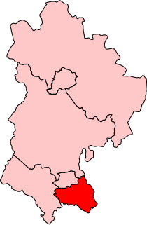
Luton South is a constituency in Bedfordshire represented in the House of Commons of the UK Parliament since 2019 by Rachel Hopkins, a member of the Labour Party.

Farley Hill is a suburb of south Luton, Bedfordshire, England. The area is roughly bounded by the Dallow Downs to the north and north-east, Stockwood Park to the south, the M1 motorway to the west, and Wilsden Avenue and Bolingbroke Road to the east.
Limbury is a suburb of Luton, in the Luton district, in the ceremonial county of Bedfordshire, England, and was formerly a village before Luton expanded around it. The area is roughly bounded by Bramingham Road to the north, Marsh Road to the south, Bramingham Road to the west, and Catsbrook Road, Runfold Avenue, Grosvenor Road, Bancroft Road and Blundell Road to the east.

Leagrave is a former village and now a suburb of Luton, in the Luton district, in the ceremonial county of Bedfordshire, England, in the northwest of the town. The area is roughly bounded by Vincent Road, Torquay Drive and High Street to the north, Roman Road and Stoneygate Road to the south, the M1 to the west, and Marsh Road and Leagrave Park to the east.
Lewsey is a suburb of Luton, about 3 miles (4.8 km) west north-west of the town centre, and a ward of the Borough of Luton, in the ceremonial county of Bedfordshire, England. The suburb is roughly bounded by Leagrave High Street to the north, Dunstable Road to the south, Poynters Road, Dunstable to the west, and the M1 to the east.

Hockwell Ring is a suburb of Luton in the north-west of the town, in the Luton district, in the ceremonial county of Bedfordshire, England. The area is roughly bounded by Brickly Road to the north, High Street and Torquay Drive to the south, the M1 motorway to the west, and Vincent Road to the east.
Bramingham is a suburb of Luton, in the Borough of Luton district, in the ceremonial county of Bedfordshire, England. The area is situated in the north of the town and is roughly bounded by the A6 to the east, Great Bramingham Wood to the west, the edge of Luton to the north, and Icknield Way to the south.
Sundon Park is a suburb of north Luton, in the Luton district, in the ceremonial county of Bedfordshire, England. The area is roughly bounded by the edge of Luton to the north, Leagrave Park to the south, the Midland Main Line to the west, and Spinney Woods and the footpath from the woods to the edge of town to the east.
Skimpot is a suburb of Luton, in the Borough of Luton, in the ceremonial county of Bedfordshire, England. The area is roughly bounded by Dunstable Road to the north, Hatters Way to the south, Skimpot Road to the west, and the M1 to the east.
Barnfield is a suburb of Luton, in the Luton district, in the ceremonial county of Bedfordshire, England. The area is roughly bounded by Old Bedford Road/Cromer Way roundabout to the north, Wardown Park and Wardown Crescent to the south, the A6 to the west, and Old Bedford Road, Elmwood Crescent and Wardown Crescent to the east.

Round Green is a suburb of Luton just over 1 mile (1.6 km) north-east of the town centre, and a ward of the Borough of Luton, in the ceremonial county of Bedfordshire, England. The area is roughly bounded by Bradgers Hill to the north, People's Park, Richmond Hill and Turners Road South to the south, Wardown Crescent and Elmwood Crescent to the west, and Vauxhall Way to the east.

Biscot is an area of Luton close to the town centre, in the Luton district, in the ceremonial county of Bedfordshire, England. The area is roughly bounded by Montrose Avenue to the north, the Midland Main Line to the west, and the A6 to the east.
Crawley Green is a suburb of south-east Luton near to London Luton Airport, in the Borough of Luton, Bedfordshire, England. The area is roughly bounded by Crawley Green Road to the north, Devon Road to the south, the Midland Main Line to the west, and Vauxhall Way to the east.
Challney is a district in Luton, in the Luton district, in the ceremonial county of Bedfordshire, England, off the main arterial road leading from Luton into Dunstable. The area is roughly bounded by Rodheath, Stoneygate Road, Roman Road, and Beechwood Road to the north, Hatters Way to the south, the M1 to the west, and Waller Avenue and Chaul End Lane to the east.
Wigmore is a suburb of Luton about 2 miles (3.2 km) east north-east of the town centre, and a ward of the Borough of Luton, in the ceremonial county of Bedfordshire, England. The suburb is roughly bounded by Telscombe Way and Someries Hill to the north, Wigmore Park to the south, Buckingham Drive and Wigmore Lane to the west, and rural Hertfordshire to the east.
Saints is a suburb of Luton, in the Luton district, in the ceremonial county of Bedfordshire, England. Located off "New Bedford Road" and situated two miles north of the Luton town centre. The area is bounded by the River Lea to the north, Montrose Avenue to the south, Blundell Road and Leagrave Road to the west, and the A6 to the east.

High Town is an inner area of Luton immediately north of Luton railway station, and a ward of the Borough of Luton, in the ceremonial county of Bedfordshire, England.
Park Town is a district of Luton, just south of the town centre, centred on Park Street, in the Luton district, in the ceremonial county of Bedfordshire, England. It is roughly bounded by Park Viaduct and Crawley Green Road to the north, New Airport Way to the South, the Midland Main Line to the East, and New Town Street and Seymour Road to the West. Park Town is one of the oldest suburbs of the now sprawling conurbation of Luton, the area first being built upon in the 19th century.
Chapel Langley is an inner city district of Luton just south west of the town centre, in the Borough of Luton, in the ceremonial county of Bedfordshire, England. It is roughly bounded by Regent Street and Adelaide Street to the north, Wilsden Avenue and Bolingbroke Road to the south, Milton Road, Napier Road, and Grove Road to the west, and Castle Street and London Road to the east. Chapel Langley is one of the oldest areas of the now sprawling conurbation of Luton.
Tin Town is a small suburb of north-east Luton, in the Borough of Luton, in the ceremonial county of Bedfordshire, England. The area is roughly bounded by Moreton Road and Turners Road North to the north, Crawley Green Road to the south, Vauxhall Way to the west, and Ashcroft Road to the east.


