| Stopsley | |
|---|---|
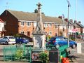
 Stopsley War Memorial | |
 Stopsley Location within Bedfordshire | |
| Population | 7,760 [1] |
| OS grid reference | TL103235 |
| Unitary authority | |
| Ceremonial county | |
| Region | |
| Country | England |
| Sovereign state | United Kingdom |
| Post town | LUTON |
| Postcode district | LU2 |
| Dialling code | 01582 |
| Police | Bedfordshire |
| Fire | Bedfordshire |
| Ambulance | East of England |
| UK Parliament | |
Stopsley is a suburb in the north-east of Luton, Bedfordshire, England. The area is roughly bounded by the edge of Luton to the north, Vauxhall Way and Turners Road North to the south, Bradgers Hill to the west, and Cannon Lane, Stapleford Road and Brays Road to the east.