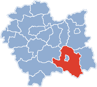
Nowy Sącz County is a unit of territorial administration and local government (powiat) in Lesser Poland Voivodeship, southern Poland, on the Slovak border. It came into being on January 1, 1999, as a result of the Polish local government reforms passed in 1998. Its administrative seat is the city of Nowy Sącz, although the city is not part of the county. The county contains five towns: Krynica-Zdrój, 31 km (19 mi) south-east of Nowy Sącz, Stary Sącz, 9 km (6 mi) south-west of Nowy Sącz, Grybów, 19 km (12 mi) east of Nowy Sącz, Piwniczna-Zdrój, 21 km (13 mi) south of Nowy Sącz, and Muszyna, 33 km (21 mi) south-east of Nowy Sącz.
Gmina Kamionka Wielka is a rural gmina in Nowy Sącz County, Lesser Poland Voivodeship, in southern Poland. Its seat is the village of Kamionka Wielka, which lies approximately 9 kilometres (6 mi) south-east of Nowy Sącz and 82 km (51 mi) south-east of the regional capital Kraków.

Biała Niżna is a village in the administrative district of Gmina Grybów, within Nowy Sącz County, Lesser Poland Voivodeship, in southern Poland. It lies approximately 3 kilometres (2 mi) east of Grybów, 21 km (13 mi) east of Nowy Sącz, and 89 km (55 mi) south-east of the regional capital Kraków.
Chodorowa is a village in the administrative district of Gmina Grybów, within Nowy Sącz County, Lesser Poland Voivodeship, in southern Poland. It lies approximately 4 kilometres (2 mi) north of Grybów, 18 km (11 mi) east of Nowy Sącz, and 85 km (53 mi) south-east of the regional capital Kraków.
Cieniawa is a village in the administrative district of Gmina Grybów, within Nowy Sącz County, Lesser Poland Voivodeship, in southern Poland. It lies approximately 8 kilometres (5 mi) west of Grybów, 12 km (7 mi) east of Nowy Sącz, and 82 km (51 mi) south-east of the regional capital Kraków.
Kąclowa is a village in the administrative district of Gmina Grybów, within Nowy Sącz County, Lesser Poland Voivodeship, in southern Poland. It lies approximately 4 kilometres (2 mi) south of Grybów, 20 km (12 mi) east of Nowy Sącz, and 91 km (57 mi) south-east of the regional capital Kraków.
Krużlowa Niżna is a village in the administrative district of Gmina Grybów, within Nowy Sącz County, Lesser Poland Voivodeship, in southern Poland. It lies approximately 7 kilometres (4 mi) north-west of Grybów, 13 km (8 mi) east of Nowy Sącz, and 82 km (51 mi) south-east of the regional capital Kraków.
Krużlowa Wyżna is a village in the administrative district of Gmina Grybów, within Nowy Sącz County, Lesser Poland Voivodeship, in southern Poland. It lies approximately 5 kilometres (3 mi) west of Grybów, 14 km (9 mi) east of Nowy Sącz, and 83 km (52 mi) south-east of the regional capital Kraków.
Ptaszkowa is a village in the administrative district of Gmina Grybów, within Nowy Sącz County, Lesser Poland Voivodeship, in southern Poland. It lies approximately 6 kilometres (4 mi) south-west of Grybów, 14 km (9 mi) east of Nowy Sącz, and 86 km (53 mi) south-east of the regional capital Kraków.
Siołkowa is a village in the administrative district of Gmina Grybów, within Nowy Sącz County, Lesser Poland Voivodeship, in southern Poland. It lies approximately 2 kilometres (1 mi) north-west of Grybów, 18 km (11 mi) east of Nowy Sącz, and 86 km (53 mi) south-east of the regional capital Kraków.
Stara Wieś is a village in the administrative district of Gmina Grybów, within Nowy Sącz County, Lesser Poland Voivodeship, in southern Poland. It lies approximately 5 kilometres (3 mi) west of Grybów, 14 km (9 mi) east of Nowy Sącz, and 83 km (52 mi) south-east of the regional capital Kraków.
Wyskitna is a village in the administrative district of Gmina Grybów, within Nowy Sącz County, Lesser Poland Voivodeship, in southern Poland. It lies approximately 7 kilometres (4 mi) north-east of Grybów, 24 km (15 mi) east of Nowy Sącz, and 89 km (55 mi) south-east of the regional capital Kraków.

Berest is a village in the administrative district of Gmina Krynica-Zdrój, within Nowy Sącz County, Lesser Poland Voivodeship, in southern Poland, close to the border with Slovakia. It lies approximately 12 kilometres (7 mi) north of Krynica-Zdrój, 24 km (15 mi) south-east of Nowy Sącz, and 97 km (60 mi) south-east of the regional capital Kraków.
Szczereż is a village in the administrative district of Gmina Łącko, within Nowy Sącz County, Lesser Poland Voivodeship, in southern Poland. It lies approximately 6 kilometres (4 mi) north-east of Łącko, 15 km (9 mi) west of Nowy Sącz, and 67 km (42 mi) south-east of the regional capital Kraków.
Wola Piskulina is a village in the administrative district of Gmina Łącko, within Nowy Sącz County, Lesser Poland Voivodeship, in southern Poland. It lies approximately four kilometres northwest of Łącko, 22 km (14 mi) west of Nowy Sącz, and 63 km (39 mi) southeast of the regional capital Kraków.
Skrzętla-Rojówka is a village in the administrative district of Gmina Łososina Dolna, within Nowy Sącz County, Lesser Poland Voivodeship, in southern Poland. It lies approximately 7 kilometres (4 mi) south-west of Łososina Dolna, 12 km (7 mi) north-west of Nowy Sącz, and 62 km (39 mi) south-east of the regional capital Kraków.
Dubne is a village in the administrative district of Gmina Muszyna, within Nowy Sącz County, Lesser Poland Voivodeship, in southern Poland, close to the border with Slovakia. It lies approximately 8 kilometres (5 mi) south-east of Muszyna, 40 km (25 mi) south-east of Nowy Sącz, and 112 km (70 mi) south-east of the regional capital Kraków.

Podegrodzie is a village in Nowy Sącz County, Lesser Poland Voivodeship, in southern Poland. It is the seat of the gmina called Gmina Podegrodzie. It lies approximately 11 kilometres (7 mi) south-west of Nowy Sącz and 72 km (45 mi) south-east of the regional capital Kraków. The village has a population of 1,700.

Stadła is a village in the administrative district of Gmina Podegrodzie, within Nowy Sącz County, Lesser Poland Voivodeship, in southern Poland. It lies approximately 8 kilometres (5 mi) south-west of Nowy Sącz and 73 km (45 mi) south-east of the regional capital Kraków.
Popowice is a village in the administrative district of Gmina Stary Sącz, within Nowy Sącz County, Lesser Poland Voivodeship, in southern Poland. It lies approximately 4 kilometres (2 mi) south-east of Stary Sącz, 10 km (6 mi) south of Nowy Sącz, and 78 km (48 mi) south-east of the regional capital Kraków.


