
Climate is the long-term average of weather, typically averaged over a period of 30 years. More rigorously, it is the mean and variability of meteorological variables over a time spanning from months to millions of years. Some of the meteorological variables that are commonly measured are temperature, humidity, atmospheric pressure, wind, and precipitation. In a broader sense, climate is the state of the components of the climate system, which includes the ocean, land, and ice on Earth. The climate of a location is affected by its latitude/longitude, terrain, and altitude, as well as nearby water bodies and their currents.

The Northern Hemisphere is the half of the Earth that is north of the Equator. For other planets in the Solar System, north is defined as being in the same celestial hemisphere relative to the invariable plane of the solar system as Earth's North Pole.

Weather is the state of the atmosphere, describing for example the degree to which it is hot or cold, wet or dry, calm or stormy, clear or cloudy. On Earth, most weather phenomena occur in the lowest layer of the planet's atmosphere, the troposphere, just below the stratosphere. Weather refers to day-to-day temperature, precipitation, and other atmospheric conditions, whereas climate is the term for the averaging of atmospheric conditions over longer periods of time. When used without qualification, "weather" is generally understood to mean the weather of Earth.

In geography, the temperate climates of Earth occur in the middle latitudes, which span between the tropics and the polar regions of Earth. These zones generally have wider temperature ranges throughout the year and more distinct seasonal changes compared to tropical climates, where such variations are often small.
The North Atlantic Oscillation (NAO) is a weather phenomenon over the North Atlantic Ocean of fluctuations in the difference of atmospheric pressure at sea level (SLP) between the Icelandic Low and the Azores High. Through fluctuations in the strength of the Icelandic Low and the Azores High, it controls the strength and direction of westerly winds and location of storm tracks across the North Atlantic. It is part of the Arctic oscillation, and varies over time with no particular periodicity.

The subtropical zones or subtropics are geographic and climate zones located to the north and south of the tropical zone. Geographically part of the north and south temperate zones, they cover the latitudes between 23°26′11.3″ (or 23.43648°) and approximately 35° in the northern and southern hemispheres.

Atmospheric circulation is the large-scale movement of air and together with ocean circulation is the means by which thermal energy is redistributed on the surface of the Earth. The Earth's atmospheric circulation varies from year to year, but the large-scale structure of its circulation remains fairly constant. The smaller scale weather systems – mid-latitude depressions, or tropical convective cells – occur "randomly", and long-range weather predictions of those cannot be made beyond ten days in practice, or a month in theory.

The polar regions, also called the frigid zones, of Earth are the regions of the planet that surround its geographical poles, lying within the polar circles. These high latitudes are dominated by floating sea ice covering much of the Arctic ocean in the north, and by the Antarctic ice sheet on the continent of Antarctica in the South.

In meteorology, a low-pressure area, low area or low is a region where the atmospheric pressure is lower than that of surrounding locations. Low-pressure systems form under areas of wind divergence that occur in the upper levels of the atmosphere. The formation process of a low-pressure area is known as cyclogenesis. In meteorology, atmospheric divergence aloft occurs in two kinds of places:

Alpine climate is the typical weather (climate) for the regions above the tree line. This climate is also referred to as a mountain climate or highland climate.
In meteorology, the polar highs are areas of high atmospheric pressure around the north and south poles; the north polar high being the stronger one because land gains and loses heat more effectively than sea. The cold temperatures in the polar regions cause air to descend to create the high pressure, just as the warm temperatures around the equator cause air to rise to create the low pressure intertropical convergence zone. Rising air also occurs along bands of low pressure situated just below the polar highs around the 50th parallel of latitude. These extratropical convergence zones are occupied by the polar fronts where air masses of polar origin meet and clash with those of tropical or subtropical origin. This convergence of rising air completes the vertical cycle around the polar cell in each latitudinal hemisphere. Closely related to this concept is the polar vortex.

This is a list of meteorology topics. The terms relate to meteorology, the interdisciplinary scientific study of the atmosphere that focuses on weather processes and forecasting.
Tropical cyclogenesis is the development and strengthening of a tropical cyclone in the atmosphere. The mechanisms through which tropical cyclogenesis occurs are distinctly different from those through which temperate cyclogenesis occurs. Tropical cyclogenesis involves the development of a warm-core cyclone, due to significant convection in a favorable atmospheric environment.

California's climate varies widely from hot desert to alpine tundra, depending on latitude, elevation, and proximity to the coast. California's coastal regions, the Sierra Nevada foothills, and much of the Central Valley have a Mediterranean climate, with warmer, drier weather in summer and cooler, wetter weather in winter. The influence of the ocean generally moderates temperature extremes, creating warmer winters and substantially cooler summers in coastal areas.

On Earth, daytime is the period of the day during which a given location experiences natural illumination from direct sunlight. Daytime occurs when the Sun appears above the local horizon, that is, anywhere on the globe's hemisphere facing the Sun. In direct sunlight the movement of the sun can be recorded and observed using a sundial that casts a shadow that slowly moves during the day. Other planets and natural satellites that rotate relative to a luminous primary body, such as a local star, also experience daytime, but this article primarily discusses daytime on Earth.

Polar amplification is the phenomenon that any change in the net radiation balance tends to produce a larger change in temperature near the poles than the planetary average. This is commonly referred to as the ratio of polar warming to tropical warming. On a planet with an atmosphere that can restrict emission of longwave radiation to space, surface temperatures will be warmer than a simple planetary equilibrium temperature calculation would predict. Where the atmosphere or an extensive ocean is able to transport heat polewards, the poles will be warmer and equatorial regions cooler than their local net radiation balances would predict. The poles will experience the most cooling when the global-mean temperature is lower relative to a reference climate; alternatively, the poles will experience the greatest warming when the global-mean temperature is higher.
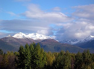
Anchorage, Alaska has a subarctic climate with the code Dfc according to the Köppen climate classification due to its short, cool summers. Average daytime summer temperatures range from approximately 55 to 78 °F ; average daytime winter temperatures are about 5 to 30 °F. Anchorage has a frost-free growing season that averages slightly over one hundred days.

The Earth's equator is an imaginary planetary line that is about 40,075 km (24,901 mi) long in circumference. The equator divides the planet into the Northern Hemisphere and Southern Hemisphere and is located at 0 degrees latitude, the halfway line between the North Pole and South Pole.

An ice cap climate is a polar climate where no mean monthly temperature exceeds 0 °C (32 °F). The climate covers areas in or near the high latitudes to polar regions, such as Antarctica, some of the northernmost islands of Canada and Russia, Greenland, along with some regions and islands of Norway's Svalbard Archipelago that have vast deserts of snow and ice. Areas with ice cap climates are normally covered by a permanent layer of ice and have no vegetation. There is limited animal life in most ice cap climates, usually found near the oceanic margins. Although ice cap climates are inhospitable to human life, there are some small research stations scattered in Antarctica and interior Greenland.

The dwarf planet Pluto has an unusual set of climate zones, due to its atypical axial configuration. Five climate zones are assigned on the dwarf planet: tropics, arctic, tropical arctic, diurnal, and polar. These climate zones are delineated based on astronomically defined boundaries or sub-solar latitudes, which are not associated with the atmospheric circulations on the dwarf planet. Charon, the largest moon of Pluto, is tidally locked with it, and thus has the same climate zone structure as Pluto itself.