
Wensleydale is a valley in North Yorkshire, England. It is one of the Yorkshire Dales, which are part of the Pennines. The dale is named after the village of Wensley, formerly the valley's market town. The principal river of the valley is the Ure, which is the source of the alternative name Yoredale. The majority of the dale is within the Yorkshire Dales National Park; the part below East Witton is within the national landscape of Nidderdale.

Bedale, is a market town and civil parish in North Yorkshire, England. Bedale Beck is a River Swale tributary, the beck forms one of the Yorkshire Dales. The dale has a predominant agriculture sector and its related small traditional trades, although tourism is increasingly important. Northallerton is 7 miles (11 km) north-west, Middlesbrough 26 miles (42 km) north-west and York is 31 miles (50 km) south-west.
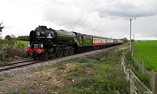
The Wensleydale Railway is a heritage railway in Wensleydale and Lower Swaledale in North Yorkshire, England. It was built in stages by different railway companies and originally extended to Garsdale railway station on the Settle-Carlisle line. Since 2003, the remaining line has been run as a heritage railway. The line runs 22 miles (35 km) between Northallerton West station, about a fifteen-minute walk from Northallerton station on the East Coast Main Line, and Redmire.

Ingleton is a village and civil parish in North Yorkshire, England. The village is 17 miles (27 km) from Kendal and 17 miles (27 km) from Lancaster on the western side of the Pennines. It is 9 miles (14 km) from Settle. The River Doe and the River Twiss meet to form the source of the River Greta, a tributary of the River Lune. The village is on the A65 road and at the head of the A687. The B6255 takes the south bank of the River Doe to Ribblehead and Hawes. All that remains of the railway in the village is the landmark Ingleton Viaduct. Arthur Conan Doyle was a regular visitor to the area and was married locally, as his mother lived at Masongill from 1882 to 1917. It has been claimed that there is evidence that the inspiration for the name Sherlock Holmes came from here.

Bedale railway station is on the Wensleydale Railway and serves the town of Bedale in North Yorkshire, England.

Leyburn railway station is on the Wensleydale Railway, a seasonal, heritage service and serves the town of Leyburn in North Yorkshire, England. During the summer months it is served by at least three trains per day; at other times of the year the service is mainly at weekends and public holidays.

Redmire railway station is the current western terminus of the Wensleydale Railway, although it is not currently served by passenger services, and serves the village of Redmire in North Yorkshire, England. Before temporary closure in 2019, it was the second busiest station on the Wensleydale Railway in terms of passenger numbers owing to its status as the western terminus of the line.

The Eryholme–Richmond branch line was opened in 1846 by the York and Newcastle Railway Company. The original section of the line ran from between a point in between Darlington and Northallerton on what is now the East Coast Main Line and the terminus at Richmond railway station.

Redmire is a village and civil parish in North Yorkshire, England. It is about 4 miles (6.4 km) west of Leyburn in Wensleydale in the Yorkshire Dales.

Wensley is a small village and civil parish in North Yorkshire, England. It consists of a few homes and holiday cottage, an inn, a pub and a historic church. It is on the A684 road 1 mile (1.6 km) south-west of the market town of Leyburn. The River Ure passes through the village.

Preston-under-Scar is a village and civil parish in North Yorkshire, England. It is situated approximately 2 miles (4 km) west of Leyburn. The village population was 120 at the 2001 census, increasing to 170 by the 2011 census. The village is mentioned in the Domesday Book as belonging to Thorfin of Ravensworth, but the tenant-in-chief being Count Alan of Bedale. The name of the village derives form a mixture of Old English and Old Norse and was originally prēost tūn sker, which translates as Priests farm under rock.

Eldon Hill is a hill in the Peak District National Park in the county of Derbyshire, England, 4 kilometres (2.5 mi) southwest of the village of Castleton. It is a 470-metre (1,540 ft) limestone hill whose pastureland is used for rough grazing, although a large proportion has been lost to limestone quarrying. It lies within the Castleton Site of Special Scientific Interest. Eldon Hill was formed when a bed of pure limestone was squeezed and upfolded by geological forces to form a dome; it is the highest limestone hill north of the River Wye.

Constable Burton railway station is a disused railway station on the Wensleydale Railway, in North Yorkshire, England. It was built to serve Constable Burton Hall, the village and the farms in this rural area.
The Yorkshire Dales Railway was a branch line linking the town of Skipton with the villages of Rylstone, Threshfield and Grassington in North Yorkshire, England. There were two stations on the line – Grassington & Threshfield and Rylstone – and a connection via the Skipton to Ilkley Line to Skipton.

Swinden Quarry is 0.62 miles (1 km) north of the village of Cracoe, and 1.9 miles (3 km) south-west of Grassington in North Yorkshire, England. It is owned by LaFarge Tarmac. The former Skipton-Grassington railway line still serves this location, and in railway terminology, the site is known as Rylstone Quarry.

St Mary's Church, Redmire is a Grade II* listed parish church in the Church of England in Redmire, North Yorkshire.

The Buxton lime industry has been important for the development of the town of Buxton in Derbyshire, England, and it has shaped the landscape around the town.
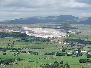
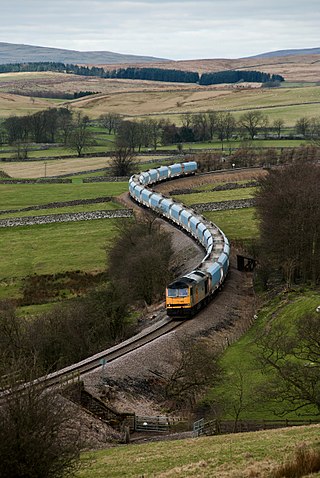
Horton Quarry is a limestone quarry near to Horton-in-Ribblesdale, North Yorkshire, England. The quarry, which is some 6 miles (9.7 km) north of Settle, has been operating since at least 1889, and produces limestone for a variety of purposes. Stone used to be exported from the quarry by rail, but now leaves by lorry, although there are plans to re-instate the railway sidings. The quarry used to produce its own lime by roasting the limestone in big kilns on the site, but the last of these were removed in the 1980s. Since 2000, the quarry has been owned and operated by Heidelberg Materials UK.

Crummackdale,, is a small valley north of the village of Austwick in the Craven District of North Yorkshire, England. The Valley is drained by Austwick Beck, which flows into the River Wenning, which in turn heads westwards to empty into the Irish Sea. Crummackdale is a narrow south west facing dale, at the south west corner of the Yorkshire Dales National Park.

Skirethorns is a hamlet in the civil parish of Threshfield, in Wharfedale, North Yorkshire, England. The hamlet is just west of the village of Threshfield, in the Yorkshire Dales National Park, some 6 miles (9.7 km) south of Kettlewell, and 8 miles (13 km) north of Skipton. Threshfield Quarry is located north-west of the hamlet, and despite its name, it is located in Skirethorns.


