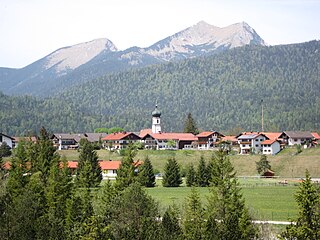
Werdenfels Castle

Last updated
Werdenfels Castle
Garmisch-Partenkirchen-Burgrain
Burg Werdenfels 2.jpg
The north side of the palas
Bavaria location map.svg
Red pog.svg
Werdenfels Castle
Germany adm location map.svg
Red pog.svg
Werdenfels Castle
Coordinates 47°30′59″N11°05′31″E / 47.516458°N 11.0919°E / 47.516458; 11.0919 Coordinates: 47°30′59″N11°05′31″E / 47.516458°N 11.0919°E / 47.516458; 11.0919
Type hill castle, spur castle
CodeDE-BY
Height795 m above  sea level (NN)
Site information
Conditionruin
Site history
Builtaround 1230
Materialsnatural stone construction from limestone
Garrison information
Occupantsadministrative centre of the County of Werdenfels

The ruins of Werdenfels Castle (German : Burg Werdenfels) stand about 80 metres above the Loisach valley between Garmisch and Farchant in the county of Garmisch-Partenkirchen in Upper Bavaria. The spur castle was used until 1632 as the administrative centre of the County of Werdenfels, but began to fall into disrepair thereafter.

Contents

The castle ruins are freely accessible and are a popular hiking destination with a good view of Garmisch-Partenkirchen and the Wetterstein Mountains.

Location

The castle is located at an elevation of 795 m above  sea level (NN) northwest of Garmisch-Partenkirchen on an eastern spur of the Kramerspitz in the Ammergau Alps. It stands about 80 metres above the valley floor and is easy to reach on well-signposted paths. The rocky terrain falls steeply from northwest to southeast into the valley, whilst southwest of the castle the land climbs rapidly. This typical castle situation enabled long-distance surveillance of the important trading route in the valley, but it was not possible to protect it directly as the castle was just too far away.

History

The foundation date of the castle has been hotly disputed in castle research circles. However, it was probably built between 1180 and 1230. Its owner and the purpose of the original fortification are also unknown. [1] [2]

In 1249, ownership of the fortress was transferred to the Prince-Bishopric of Freising and it was occupied with guardians (Burghütern) or governors (Pfleger). In 1294 Count Berthold III of Eschenlohe gave the Bishopric part of his county and was appointed as the castle guardian. After the creation of Freising territory, the County of Werdenfels, the castle served as the administrative and jurdical centre. However, not all governors took up residence in the castle. The county was generally regarded as "the best part of the Imperial Principality of Freising" (Carolus Meichelbeck). It supplied "chamois and red deer venison and game... wood, marble" that could be transported on the rivers Isar and Loisach directly to the cathedral town.

In the 15th century, Freising had to enfeoff the castle several times due to financial difficulties. The structural condition of the castle seems to have deteriorated to the beginning of the 17th century such that the governor's seat was moved in 1632 into a new administrative building on the Wang. From 1676 the fortress was exploited as a quarry. For example, numerous stone blocks from castle were re-used for the new baroque parish churches of Farchant and Garmisch.

As part of the seizure of church land in the Napoleonic era, the castle and county went to the Kingdom of Bavaria. Its population of roughly 5,000 which had hitherto enjoyed imperial immediacy found it difficult at first to get used to their new masters. An 1806 document by a Munich official complains that "many Werdenfelßer still have no Bavarian heart!"

In 1822 the Bavarian privy council, Ignaz von Rudhart, acquired the ruins, since when it has been privately owned.

In 1905-06, the walls were secured and partially rebuilt. After the tops of the walls were secured in 1961/63, further restoration finally began in 1986; this has continued sporadically since.

Furstengang Freising - Burg Werdenfels.jpg
Werdenfels Castle and Schwaigwang in 1700

Description

The construction material for the castle was the local limestone, which was quarried in the Schlosswald ("Castle Wood") above the fortification. Of interest here are the remains of six ring-shaped lime kilns which were archaeologically investigated in 1997.

To the south and west a shallow neck ditch guards the position. The approximately square, elevated inner ward (27.6 × 24.8 metres) has two outer wards to the north and west dating to the 14th and 15th centuries.

The bergfried rose at or over the northwestern corner of the inner ward, but was completely demolished around 1728/30 leaving a pile of rubble today. The tower was also used in the 15th and 16th centuries as a gaol. Better preserved are the north side and an internal wall of the palas (24.8 × 11.4 metres) [3] and the stonework of the two outer wards with its – largely renovated – 'Mittertor ("Central Gate").

The partially preserved north wall of the palas is pierced on the ground floor by three large pointed arches whose actual function remains a puzzle.

In its last phase of expansion, the castle was probably more of an administrative seat than a fortification and would not have withstood a serious siege for very long. The wall thicknesses only average about 90 centimetres and the main direction of attack was not reinforced or protected by flanking towers. The most defensible part of the castle was the high medieval bergfried of which little is known apart from a few 17th and 18th century illustrations.

Werdenfels Castle's weaknesses as a fortification had been noted by castle researcher, Otto Piper. He recognised that the fortress "so far as the remaining walls are concerned, conspicuously lacks the positions and facilities for a sustained defence“. As a result of his research he finally came to the conclusion that the ruins "no longer correspond to the older castle".

The associated domestic yard lay to the south, below the castle in the valley roughly where the old district office (Amtshaus) is today (Schwaige Wang).

Burg Werdenfels 3.jpg
Burg Werdenfels 4.jpg
Burg Werdenfels.jpg
Left: the interior of the palas with its internal wall. Centre: the first outer wall and the Mittertor. Right: the west side with the wall of the outer ward and the palas.

Literature

Related Research Articles

Garmisch-Partenkirchen Municipality in Bavaria, Germany

Garmisch-Partenkirchen, nicknamed Ga-Pa, is an Alpine ski town in Bavaria, southern Germany. It is the seat of government of the district of Garmisch-Partenkirchen, in the Oberbayern region, which borders Austria. Nearby is Germany's highest mountain, Zugspitze, at 2,962 metres (9,718 ft) above sea level.

Leutasch is a municipality in the northern part of the district Innsbruck-Land in the Austrian state of Tyrol about 30 km northwest of Innsbruck and 10 km northwest of Seefeld in Tirol

<i>Bergfried</i>

Bergfried is a tall tower that is typically found in castles of the Middle Ages in German-speaking countries and in countries under German influence. Friar describes it as a "free-standing, fighting-tower". Its defensive function is to some extent similar to that of a keep in English or French castles. However, the characteristic difference between a bergfried and a keep is that a bergfried was typically not designed for permanent habitation.

County of Werdenfels

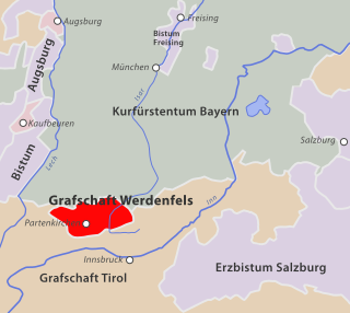
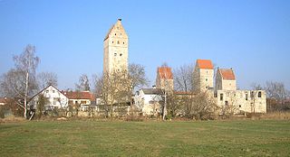
The County of Werdenfels in the present-day Werdenfelser Land in South Germany was a county that enjoyed imperial immediacy that belonged to the Bishopric of Freising from the late 13th century until the secularisation of the Bishopric in 1803.

Werdenfelser Land

The Werdenfelser Land is a region of Upper Bavaria that extends from Mittenwald in the south to Farchant. It includes parts of the Bavarian Alps. From the Middle Ages until the Thirty Years' War, the Werdenfelser Land was subject to the Prince-Bishop of Freising, not the Duke of Bavaria.

Altenstein Castle (Lower Franconia)

Altenstein Castle is a ruined castle in Altenstein in the district of Haßberge in Lower Franconia, Germany. The family seat of the lords of Stein zu Altenstein, which died out in the 19th century, is located 40 kilometres north of the city of Bamberg and, since the end of the 20th century, has been managed by the district of Haßberge. The castle was renovated around the turn of the millennium.

Salzburg Castle

Salzburg Castle stands on the edge of a plateau above the town of Bad Neustadt an der Saale in Lower Franconia in southern Germany. The large Ganerbenburg is still partly occupied today and not all areas are accessible to the public.

Elevated entrance Entrance of medieval castles

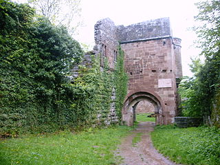
An elevated entrance is a type of entrance, common in the design of medieval castles, that is not accessible from ground level, but lies at the level of an upper storey. The elevated entrance is the lowest and frequently the only way of entering a fortified building or residence. In the case of circular towers, a large opening in the main wall at ground level was a potential weakness and experts on castle design have argued that the elevated entrance served a structural as well as defensive purpose.

Schlossberg Castle (Seefeld in Tirol)

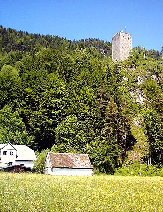
Schlossberg Castle is a ruined toll castle in the municipality of Seefeld in Tirol in the district of Innsbruck Land in the Austrian state of Tyrol.

Alt-Trauchburg Castle

The ruins of Alt-Trauchburg Castle, also called the Alttrauchburg or Trauchburg, lie above the Weitnau hamlet of Kleinweiler in the county of Oberallgäu in Swabia. Large parts of the original stone walls of the high- to post-medieval castle remain. The ruins are some of the best preserved in the Allgäu region of Germany.

Grenzau Castle

Grenzau Castle is a ruined spur castle at 250 m above sea level (NN) near Höhr-Grenzhausen in the county of Westerwaldkreis in the state of Rhineland-Palatinate. It is the only castle in Germany with a triangular bergfried.

Wellheim Castle

Wellheim Castle is a former fortification in Upper Bavaria. The ruins of the old rock castle stand dominantly on Jurassic rocks above the market town of Wellheim in the ancient Danube valley. It was abandoned in the 18th century and partially demolished.

Sayn Castle

The ruins of Sayn Castle, the 12th century family castle of the counts of Sayn and Sayn-Wittgenstein, are in Sayn, part of the borough of Bendorf on the Rhine, between Koblenz and Neuwied in the county of Mayen-Koblenz in the German state of Rhineland-Palatinate.

Vilsegg Castle

Vilsegg Castle is a former fortification in the Austrian state of Tyrol that stands about a kilometre northwest of the little town of Vils, between Pfronten and Füssen, a few hundred metres away from the Austro-German border.

Rauheneck Castle (Ebern)

Rauheneck Castle is a ruined administrative castle of the Bishopric of Würzburg in the Haßberge in the county of Haßberge, Lower Franconia, Bavaria (Germany). The site, which was badly in need of repair, was closed until 2006 due to the danger of collapse but has been accessible again since the start of, as yet unfinished, emergency repair work.

Hohenfreyberg Castle

Hohenfreyberg Castle, together with Eisenberg Castle directly opposite, forms a castle group in the southern Allgäu that is visible from a long way off. It is located about four kilometres north of Pfronten in the county of Ostallgäu. The late mediaeval hilltop castle was abandoned during the Thirty Years’ War and set on fire. From 1995 to 2006 the former aristocratic seat was comprehensively made safe and conserved as part of a closely observed "example of renovation".

Falkenstein Castle (Höllental) Ruined hill castle

Falkenstein Castle is a ruined hill castle near Freiburg im Breisgau on the territory of the present-day municipality Breitnau in the county of Breisgau-Hochschwarzwald in the German state of Baden-Württemberg. The castle site lies in a triangle formed by the entrance of the Höllental valley – the Lower Höllental and the Engenbach valley, not far from the Buchenbach village of Falkensteig, 617.6 m above sea level (NN) on a rocky crag that is very difficult to get to today. Of the castle itself only a few wall remains are left. It is one of the less well preserved ruins in the Breisgau.

Husen Castle (Hausach)

Husen Castle is a ruined hill castle of the high medieval period in the valley of the Kinzig in the Black Forest. It is sited above the town of Hausach in the county of Ortenaukreis in the German state of Baden-Württemberg.

Nassenfels Castle

Nassenfels Castle stands at the edge of the market village of Nassenfels in the county of Eichstätt in Upper Bavaria. The former water castle is still lived in and may only be viewed from the outside.

Wernerseck Castle

Wernerseck Castle, also called the Kelterhausburg, is a late medieval hill castle in the municipality of Ochtendung in the county of Mayen-Koblenz in the German state of Rhineland-Palatinate. It owes its name to its founder and lord of the castle, the Archbishop of Trier, Werner of Falkenstein (1388–1418). "Wernerseck" means "Werner's corner".

References

  1. Joachim Zeune (1999), "Die Burg des frühen 13. Jahrhunderts", in Heinrich Spichtinger (ed.), Spuren der Vergangenheit (in German), Garmisch-Partenkirchen: Adam-Verlag, p. 17
  2. Werner Meyer (1986), Burgen in Oberbayern (in German), Würzburg
  3. All dimensions from Zeune