Wermsdorf

Last updated

Wermsdorf
Wermsdorf Aerial.jpg
Aerial view
Wappen Wermsdorf.svg
Location of Wermsdorf within Nordsachsen district
Wermsdorf in TDO.pngArzbergDahlenNaundorf
Germany adm location map.svg
Red pog.svg
Wermsdorf
Saxony location map.svg
Red pog.svg
Wermsdorf
Coordinates: 51°17′N12°57′E / 51.283°N 12.950°E / 51.283; 12.950
Country Germany
State Saxony
District Nordsachsen
Government
   Mayor (202229) Matthias Müller [1]
Area
  Total104.41 km2 (40.31 sq mi)
Elevation
185 m (607 ft)
Population
 (2021-12-31) [2]
  Total5,162
  Density49/km2 (130/sq mi)
Time zone UTC+01:00 (CET)
  Summer (DST) UTC+02:00 (CEST)
Postal codes
04779
Dialling codes 034364
Vehicle registration TDO, DZ, EB, OZ, TG, TO
Website www.wermsdorf.de

Wermsdorf is a municipality in the Nordsachsen district in Saxony, Germany. Two hunting castles of the Saxon Dukes and Kings are to be found here.

Contents

Wermsdorf and its sub-districts 2011 Wermsdorf und seine Ortsteile.jpg
Wermsdorf and its sub-districts 2011

Geography

Landscape

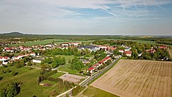
Wermsdorf is situated within Wermsdorf Forest a wooded area of some 30 km/sq, less than 7.0 km to the north-west of Mügeln. The south side of Wermsdorf is deforested and looks out over a fairly flat landscape (being at the southerly end of the North German Plain) of agricultural land set out in crops. There are a number of man-made lakes suitable for recreation in the vicinity. A quarry lies to the north-east of Wermsdorf.

Sights

Hubertusburg Wermsdorf-Panorama.jpg
Hubertusburg

There are several historical buildings, some of which have been refurbished in the last few years. The most prominent is Hubertusburg, which, in spite of its more modest size, and bereft of the grand sweep of terraces-cum-steps of Sanssouci in Potsdam, does have a recognizably similar layout to Sanssouci, with the main building overlooking formal gardens, graveled walkways, outbuildings and a wooded area.

History

Nothing is known about the 638 [3] ha large Waldhufendorf settlement as seat of Henricus de Weenboldisdorf mentioned in a document dating from 1206. The first documented mention of Wermsdorf was in 1215. Additional early mentions include:

In 1350 the place was recognised as an oppidum for the first time. [4]

In 1721 construction began on a large Jagdschloss (hunting lodge), the Hubertusburg. Elector Friedrich August II of Saxony extended the palace in 1743 and it became one of the largest baroque hunting lodges in Europe. The Saxonian post station was founded in Wermsdorf in 1722. In 1756 the Seven Years' War broke out and in 1761 the Hubertusburg was plundered by the Prussians and has never recovered since. In 1763 the Hubertusburg Peace Treaty was signed, so-called even though it may have been signed in nearby Schloss Dahlen.

The Hubertusburg was used as an academy for Luftwaffe officers from 1941.

On 25 April 1945 the U.S. Army arrived in Wermsdorf. [5] On 5 May 1945 the Soviet army took over.

Monuments

King Albert Monument

Wermsdorf - King Albert Monument in 2011 Konig-Albert.jpg
Wermsdorf – King Albert Monument in 2011

In May 1907 the Saxon Military Fraternity of Wermsdorf proposed building a monument for the late Albert of Saxony. To this end, Emperor Wilhelm II gifted the fraternity a bronze cannon barrel. The sculptor was Georg Bernkopf. One year later, the statue of Albert as a huntsman in a hunting cap and with a double barrel shotgun was unveiled in the presence of Frederick Augustus III of Saxony . [6]

Death March Memorial

At the Old Hunting Lodge, there is a monument stone to commemorate ten unknown concentration camp prisoners who died in the vicinity on a death march in Spring 1945 from Stalag VIIIC in Zagan/Poland, and were buried in the Anstaltsfriedhof. [7]

Zeppelin Stone

Monument to commemorate the landing of a Zeppelin airship in Wermsdorf on 12 July 1914.

Recreational activities.

There are numerous cycling routes of low elevation and trail-ways suitable for walking scattered throughout the nearby Wermsdorf Woods. The nearby lakes are available for bathing, boating and fresh water fishing. Wermsdorf also has a number of hostelries for the enjoyment of traditional German food and drink.

Related Research Articles

<span class="mw-page-title-main">Moritzburg, Saxony</span> Municipality in Saxony, Germany

Moritzburg is a municipality in the district of Meissen in Saxony, Germany, between Meissen itself, an early centre of Saxony, and today's capital Dresden. It is most famous for its Baroque castle, Schloss Moritzburg.

<span class="mw-page-title-main">Strehla</span> Town in Saxony, Germany

Strehla is a small town in the district of Meißen, Saxony, Germany. It is located on the river Elbe, north of Riesa. This place name means arrow in Sorbian. Strehla includes the following subdivisions:

<span class="mw-page-title-main">Kreischa</span> Municipality in Saxony, Germany

Kreischa is a municipality in the Sächsische Schweiz-Osterzgebirge district, Saxony, Germany. It directly borders the Saxon capital Dresden and consists of 14 districts.

<span class="mw-page-title-main">Oschatz</span> Municipality in Saxony, Germany

Oschatz is a town in the district Nordsachsen, in Saxony, Germany. It is located 60 km east of Leipzig and 60 km west of Dresden.

<span class="mw-page-title-main">Augustusburg</span> Town in Saxony, Germany

Augustusburg is a town in the district of Mittelsachsen, in Saxony, Germany. It is situated 12 km east of Chemnitz. Augustusburg is known for its Jagdschloss, the hunting lodge of the same name.

<span class="mw-page-title-main">Bad Elster</span> Town in Saxony, Germany

Bad Elster is a spa town in the Vogtlandkreis district, in Saxony, Germany. It lies on the border of Bavaria and the Czech Republic in the Elster gebirge hills. It is situated on the river White Elster, and is protected from extremes of temperature by the surrounding wooded hills. It is 25 km southeast of Plauen, and 25 km northwest of Cheb. It is part of the Freunde im Herzen Europas microregion.

<span class="mw-page-title-main">Bernstadt auf dem Eigen</span> Municipality in Saxony, Germany

Bernstadt auf dem Eigen is a town in the Görlitz district, in Saxony, Germany. It is situated 16 km north of Zittau, and 16 km southwest of Görlitz.

<span class="mw-page-title-main">Dahlen, Saxony</span> Town in Saxony, Germany

Dahlen is a town in the district Nordsachsen, in Saxony, Germany. Since 1994, the town of Dahlen consists of the old town with the addition of neighbouring villages Börln with Bortewitz, Radegast and Schwarzer Kater, Großböhla, Neuböhla and Kleinböhla, Schmannewitz and Ochsensaal.

<span class="mw-page-title-main">Ehrenfriedersdorf</span> Town in Saxony, Germany

Ehrenfriedersdorf is a town in the district of Erzgebirgskreis, in Saxony, Germany. It is situated 8 km northwest of Annaberg-Buchholz, and 21 km south of Chemnitz.

<span class="mw-page-title-main">Kitzscher</span> Town in Saxony, Germany

Kitzscher is a town in the Leipzig district, in Saxony, Germany.

<span class="mw-page-title-main">Lauta</span> Town in Saxony, Germany

Lauta (German) or Łuty is a town in the district of Bautzen, in Saxony, Germany. It is situated 10 km west of Hoyerswerda, and 10 km southeast of Senftenberg.

<span class="mw-page-title-main">Mügeln</span> Town in Saxony, Germany

Mügeln is a town in the district Nordsachsen, in Saxony, Germany. It is located 9 km southwest of Oschatz and 14 km northwest of Döbeln. The town has a population of approximately 5,808 people.

<span class="mw-page-title-main">Waldheim, Saxony</span> Town in Saxony, Germany

Waldheim is a town in Mittelsachsen district, in Saxony, Germany.

<span class="mw-page-title-main">Neukirch/Lausitz</span> Town in Saxony, Germany

Neukirch/Lausitz (German) or Wjazońca is a municipality in Upper Lusatia in the district of Bautzen, in the state of Saxony in eastern Germany. It belongs to the district of Bautzen and is situated in several valleys of the mountain region Lausitzer Bergland, near the hill "Valtenberg" that reaches about 587 metres. It has about 5,066 inhabitants in an area of 21.32 km², a population density of 240 per km². The German name Lausitz means Lusatia.

<span class="mw-page-title-main">Eppendorf, Saxony</span> Municipality in Saxony, Germany

Eppendorf is a municipality in the district of Mittelsachsen, in Saxony, Germany.

<span class="mw-page-title-main">Crostwitz</span> Municipality in Saxony, Germany

Crostwitz (German) or Chrósćicy is a village and municipality in the center of the German district of Bautzen in Saxony. It is located in Upper Lusatia and is one of the centres of the Sorbian settlement area in Saxony.

<span class="mw-page-title-main">Nebelschütz</span> Municipality in Saxony, Germany

Nebelschütz (German) or Njebjelčicy is a Sorbian village in the district of Bautzen of Saxony in south-east Germany. It lies to the south-east of Kamenz.

<span class="mw-page-title-main">Arzberg, Saxony</span> Municipality in Saxony, Germany

Arzberg is a municipality in the district Nordsachsen, in Saxony, Germany.

<span class="mw-page-title-main">Liebschützberg</span> Municipality in Saxony, Germany

Liebschützberg is a municipality in the district Nordsachsen, in Saxony, Germany.

<span class="mw-page-title-main">Collmberg</span> Mountain in Germany

Collmberg, regionally and colloquially called Collm, is the highest elevation in the Nordsachsen district and of the Northwest Saxon Basin, situated 6 km west of Oschatz near the small village of Collm. Until the 19th Century it was also called Spielberg and has also been known as Oschatzer Collm.

References

  1. Gewählte Bürgermeisterinnen und Bürgermeister im Freistaat Sachsen, Stand: 17. Juli 2022, Statistisches Landesamt des Freistaates Sachsen.
  2. "Bevölkerung des Freistaates Sachsen nach Gemeinden am 31. Dezember 2021" (XLS) (in German). Statistisches Landesamt des Freistaates Sachsen. 2022.
  3. 1 2 Karlheinz Blaschke, Susanne Baudisch: Historisches Ortsverzeichnis von Sachsen. Leipziger Universitätsverlag, 2006, ISBN   978-3-937209-15-9.
  4. Gerhard Billig: Wermsdorf in ur- und frühgeschichtlichen Zeiten. in: 800 Jahre Wermsdorf. 1206–2006. Sax Verlag, Beucha 2006, ISBN   3-934544-93-2, S. 19 ff.
  5. Eckhard Riedel: Nach der Monarchie bis zum Ende der Hitlerdiktatur (1918–1945). In: 800 Jahre Wermsdorf. 1206–2006. Sax Verlag, Beucha 2006, ISBN   3-934544-93-2, S. 73 ff.
  6. König Albert Denkmal. Gemeinde Wermsdorf, retrieved 27 February 2011.
  7. Gedenkstätten für die Opfer des NS II. Hrsg. Bundeszentrale für politische Bildung, Bonn, S. 710, 763.