Altötting is a Landkreis (district) in Bavaria, Germany. It is bounded by Austria and the Bavarian districts of Traunstein, Mühldorf and Rottal-Inn.

The Bavarian Forest is a wooded, low-mountain region in Bavaria, Germany that is about 100 kilometres long. It runs along the Czech border and is continued on the Czech side by the Bohemian Forest. Most of the Bavarian Forest lies within the province of Lower Bavaria, but the northern part lies within Upper Palatinate. In the south it reaches the border with Upper Austria.
The Regen is a river in Bavaria, Germany, and shortly in the Czech Republic. It is a left tributary of the Danube, at Regensburg, Germany.

The Isar is a river in Austria, and Bavaria. Its source is in the Karwendel mountain range of the Alps. The Isar river enters Germany near Mittenwald and flows through Bad Tölz, Munich, and Landshut before reaching the Danube near Deggendorf. With 295 km length, it is among the longest rivers in Bavaria. It is Germany's second most important tributary of the Danube.
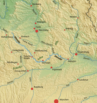
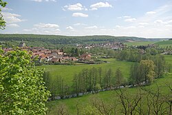
The Altmühl is a river in Bavaria, Germany. It is a left tributary of the river Danube and is approximately 230 kilometres (140 mi) long.

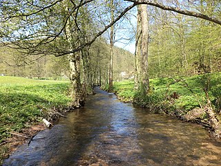
The White Main, is the larger and shorter of the two headstreams of the river Main. It rises in the Fichtel Mountains and merges near Steinenhausen, southwest of Kulmbach, with the left-hand, southern headstream, the Red Main, to form the Main. The length of the White Main is 51.7 km. The source of the White Main lies on light granite rock, which lends it its white colouration.
Schweinfurt is a Landkreis (district) in the northwestern part of Bavaria, Germany. Neighboring districts are Bad Kissingen, Rhön-Grabfeld, Haßberge, Bamberg, Kitzingen, Würzburg and Main-Spessart. The district-free city Schweinfurt is surrounded by the district.

The Tauber is a river in Franconia, Germany. It is a left tributary of the Main and is 132 km (82 mi) in length. The name derives from the Celtic word for water.
Arnstein is a town in the Main-Spessart district in the Regierungsbezirk of Lower Franconia (Unterfranken) in Bavaria, Germany.

The Würm is a river in Bavaria, Germany, right tributary of the Amper. The length of the river is 39.8 kilometres (24.7 mi), or 76.3 kilometres (47.4 mi) including the Steinbach, the main feed of Lake Starnberg. It drains the overflow from Lake Starnberg and flows swiftly through the villages of Gauting, Krailling, Planegg, Gräfelfing and Lochham as well as part of Munich before joining, near Dachau, the Amper, which soon afterwards flows into the Isar and eventually flowing into the Danube. Although the Würm is not a very large river, it is well known as it gave its name to the Würm glaciation.

Gemünden am Main is a town in the Main-Spessart district in the Regierungsbezirk of Lower Franconia (Unterfranken) in Bavaria, Germany and lies roughly 40 km down the Main from Würzburg. Gemünden has around 10,000 inhabitants.

The Itz is a river of Thuringia and Bavaria, Germany.

The Steigerwald is a hill region up to 498.5 m above sea level (NHN) in the Bavarian-Franconian part of the South German Scarplands between Würzburg and Nuremberg. It is part of the Keuper Uplands, and within it, it is continued to the north-northeast and right of the river Main, by the Haßberge, and to the south-southwest by the Franconian Heights. Part of the region is a designated as the Steigerwald Nature Park.

The Kahl is a river in the northern Spessart in Bavaria and Hesse, Germany. It is a right tributary of the Main and is 35.6 km (22.1 mi) long. The name Kahl comes from the Old High German word kaldaha, which means cool and clear. The Kahl rises from two sources left and right of the road at the foot of the Spessart hills, near Kleinkahl. These springs produce 50–60 litres per second. The Kahl flows into the river Main in Kahl am Main. The mouth is near the old Kahl Nuclear Power Plant. The largest tributaries are Westerbach, Sommerkahl, Reichenbach and Geiselbach.

Wiesent is a river located in Bavaria, Germany. It is a right tributary of the river Regnitz. It is the main river of the Franconian Switzerland region, rising near the village Steinfeld. It flows through the towns Hollfeld, Muggendorf and Ebermannstadt, and joins the Regnitz in Forchheim.
Aschbach is a river of Lower Franconia, Bavaria, Germany.

Aurach is a river of Bavaria, Germany. It is a left tributary of the Regnitz in Upper Franconia.

Flossach is a 21.9-kilometre-long (13.6 mi) river in Bavaria, Germany. It is a right tributary of the Mindel and an indirect right tributary of the Danube.
Haslochbach is a small river of Bavaria, Germany. It flows into the Main east of Hasloch.

Tannbach is a brook that is 8.7 kilometres (5.4 mi) long in north-east Bavaria and southern Thuringia, Germany.