West Bank Park

Last updated

West Bank Park
West Bank Park - Acomb Road - geograph.org.uk - 1742944.jpg
West Bank Park – Acomb Road
West Bank Park
Location Holgate, York, England
OS grid SE 582511 [1]
Coordinates 53°57′12″N1°06′39″W / 53.9534°N 1.1109°W / 53.9534; -1.1109 [2]
Area20 acres (8.1 ha)
Created1936–1938
Awards Green Flag

West Bank Park is a public open space in Holgate, the city of York, in Northern England. The area was previously a nursery owned by James Backhouse before being converted into a park in the 1930s.

Contents

History

In the 19th century, the botanist James Backhouse owned a nursery in Holgate which covered 100 acres (40 ha), and was known worldwide, having the nickname of the "Kew of the North". [3] [4] During the second half of the 19th century, Backhouse had several large greenhouses built to grow ferns, with the Backhouse family being credited as "Britain's leading cultivators of exotic ferns." [5] Part of this land became West Bank Park in the early 20th century, and now has grassed areas and woodland. [6] The northern part of the woodland had previously been the site of a small lake, which archaeological evidence showed had silted up by the time the area was converted into a park. [7] [8] [9] The land was converted into a park between 1936 and 1938, but larger-scale development of the area was halted until after the Second World War, and then West Bank House was demolished in 1974. [10] [11] The house had been built by Backhouse in 1853, and then sold to Sir James Hamilton in 1910, alter becoming a home for unwed mothers. [12] Less maintenance of the park and rising crimes rates saw the formation of the Friends of West Bank Park in 1993. [13]

In the northern part of the park is a grade II listed statue of Queen Victoria. It was created in 1905 by George Milburn and intended to commemorate the reign of Queen Victoria by being placed in the Guildhall in York. However, at some point during the 20th century it was removed to West Bank Park, and has been renovated as recently as 2018. [14] [15] [16]

In 2013, the council stopped locking the park gates on an evening in an effort to save money. [17] The locking of the gates was reinstated by the Friends of West Bank Park in 2016, which saw vandalism and crime rates in the park drop by 50%. [18] [19] West Bank Park has been awarded a green flag for every year between 2006 and 2024. [20] [21] [22]

Facilities and transport

Buses connect the city centre with West Bank Park; services 1 and 5, both run by FirstBus York, though service number 1 runs directly past the parks' northern entrance. [23] [24] [25] The park has children's play areas, bowling greens, woodland, and standard and adapted toilets. [26] One of the children's play areas additionally has a basketball court, and there is a children's wildlife area with a pond, and bird feeding. [27] [28] The mature woodland at the north end of the park includes dawn and giant redwoods. [29]

The park used to have a cafe by the bowling greens, which was also used to teach cooking skills to those with special needs. It closed down in 2009, and efforts have been made to re-open the cafe, or to open a newer cafe in the old gate-keeper's lodge. [30] [31]

Related Research Articles

<span class="mw-page-title-main">West Yorkshire</span> County of England

West Yorkshire is a metropolitan and ceremonial county in the Yorkshire and the Humber region of England. It borders North Yorkshire to the north and east, South Yorkshire and Derbyshire to the south, Greater Manchester to the south-west, and Lancashire to the west. The city of Leeds is the largest settlement.

<span class="mw-page-title-main">Morley, West Yorkshire</span> Market town and civil parish in West Yorkshire, England

Morley is a market town and a civil parish within the City of Leeds metropolitan borough, in West Yorkshire, England. Morley is the largest town in the borough after Leeds itself. Morley forms part of the Heavy Woollen District.

<span class="mw-page-title-main">Pudsey</span> Town in West Yorkshire, England

Pudsey is a market town in the City of Leeds Borough in West Yorkshire, England. It is located midway between Bradford city centre and Leeds city centre. Historically in the West Riding of Yorkshire, it has a population of 22,408.

<span class="mw-page-title-main">Harrogate</span> Town in North Yorkshire, England

Harrogate is a spa town in the district and county of North Yorkshire, England. Historically in the West Riding of Yorkshire, the town is a tourist destination and its visitor attractions include its spa waters and RHS Harlow Carr gardens. 13 miles (21 km) away from the town centre is the Yorkshire Dales National Park and the Nidderdale AONB.

<span class="mw-page-title-main">Temple Bar, London</span> Monument in London, England

Temple Bar was the principal ceremonial entrance to the City of London from the City of Westminster. In the middle ages, London expanded city jurisdiction beyond its walls to gates, called ‘bars’, which were erected across thoroughfares. To the west of the City of London, the bar was located adjacent to the area known as the Temple. Temple Bar was situated on the historic royal ceremonial route from the Tower of London to the Palace of Westminster, the two chief residences of the medieval English monarchs, and from the Palace of Westminster to St Paul's Cathedral. The road east of the bar within the City was Fleet Street, while the road to the west, in Westminster, was The Strand.

<span class="mw-page-title-main">Hemsworth</span> Town and civil parish in West Yorkshire, England

Hemsworth is a town and civil parish in the City of Wakefield, West Yorkshire, England. Historically within the West Riding of Yorkshire and had a population of 13,311 at the 2001 census, with it increasing to 13,533 at the 2011 Census.

Woodlands is an area of Glasgow, Scotland. Situated on the north-west edge of the city centre, Woodlands is located within Glasgow's fashionable West End, east of Hillhead, south of Woodside, north of the Park District and Kelvingrove Park, and west of Charing Cross and Garnethill.

The Ainsty or the Ainsty of York was a historic district of Yorkshire, England, west of the city of York. Originally a wapentake or subdivision of the West Riding of Yorkshire it later had a unique status as a rural area controlled by the corporation of the city.

<span class="mw-page-title-main">Rufforth</span> Village in North Yorkshire, England

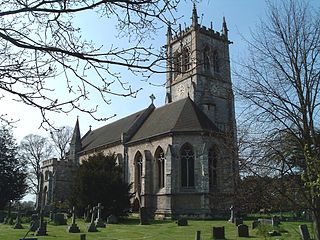
Rufforth is a village in the civil parish of Rufforth with Knapton, in the unitary authority area of the City of York in North Yorkshire, England. It lies about 4 miles (6.4 km) west of York. The village is mentioned in the Domesday Book and dates from Saxon times.

<span class="mw-page-title-main">Escrick</span> Village and civil parish in North Yorkshire, England

Escrick is a village and civil parish in North Yorkshire, England. It was in the historic East Riding of Yorkshire, but since 1974 has come under North Yorkshire. It is approximately equidistant between Selby and York on what is now the A19 road.

<span class="mw-page-title-main">Endcliffe Park</span> Park in Sheffield, South Yorkshire, England

Endcliffe Park is a large park in the city of Sheffield, South Yorkshire, England. The park was opened in 1887 to commemorate the Jubilee of Queen Victoria. When travelling West from the city centre it is the first in a series of parks and green spaces, known collectively as the Porter Valley Parks, all of which lie along the course of the Porter Brook. The next park in the sequence is Bingham Park, separated from Endcliffe Park by Rustlings Road. In 1924 Patrick Abercrombie said of the parks, "The Porter Brook Parkway, consisting as it does of a string of contiguous open spaces, is the finest example to be found in this country of a radial park strip, an elongated open space, leading from a built-up part of the city direct into the country, the land occupied being a river valley and so for the greater part unsuitable for building."

<span class="mw-page-title-main">Risby, East Riding of Yorkshire</span> Place in the East Riding of Yorkshire, England

Risby is the site of a deserted village and former stately home in the civil parish of Rowley in the East Riding of Yorkshire, England. It is approximately 3.5 miles (5.6 km) south-west of Beverley and 1 mile (1.6 km) west of the A164 road.

<span class="mw-page-title-main">Peel Park, Bradford</span>

Peel Park is a 22.6-hectare (56-acre) urban public park in the Bolton and Undercliffe area of Bradford, England, located about 0.75 miles (1.2 km) north-east of the city centre, and named after Sir Robert Peel (1788–1850). Peel Park was Bradford's first public park and is on the English Heritage and National Register of Historic Parks and Gardens online databases. The park is a Green Flag Award winner and has been for a number of years.

<span class="mw-page-title-main">City of York</span> Unitary authority area in North Yorkshire, England

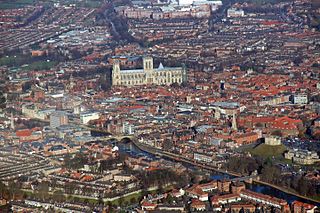
The City of York, officially simply "York", is a unitary authority area with city status in the ceremonial county of North Yorkshire, England.

<span class="mw-page-title-main">RAF Rufforth</span> Former Royal Air Force base in Yorkshire, England

Royal Air Force Rufforth or RAF Rufforth is a former Royal Air Force station located near Rufforth in North Yorkshire, England. It was used by only one operational squadron on long-range bombing missions during the Second World War, with most flying dedicated to conversion units under the auspices of nearby RAF Marston Moor. Post-war, the RAF used the site to house maintenance units, gliding schools and observation flights. It was completely disposed of by the MoD in 1981, and now is used for civilian light aircraft and glider flying.

<span class="mw-page-title-main">Holgate, York</span> Suburb of York, North Yorkshire, England

Holgate is a suburb of York in the ceremonial county of North Yorkshire, England. It is located about 1 mile west of Micklegate Bar in the city walls. Holgate is also the name of an electoral ward in the City of York unitary authority. The ward is currently bounded by the River Ouse from Scarborough Bridge to Ouse Acres on its northern boundary. Carr Lane and Ouse Acres on one side, and the intersection of York Road and Acomb Road on the other, make up its western boundary. The remainder of the southern boundary follows Moorgate and Holgate Beck to the East Coast Main Line railway which completes the eastern boundary as far as the River Ouse/Scarborough Bridge.

<span class="mw-page-title-main">Knapton, York</span> Village in North Yorkshire, England

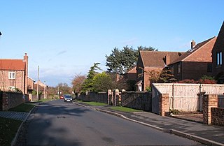
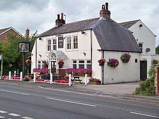
Knapton is a village in the civil parish of Rufforth with Knapton, in the City of York unitary authority area and ceremonial county of North Yorkshire, England. It is 3 miles (5 km) west of York and is bounded by the village of Acomb to the east, the B1224 to the south, the A59 to the north and the A1237 York Outer Ring Road to the west.

<span class="mw-page-title-main">Blossom Street</span> Street in York, England

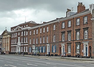
Blossom Street is a road in York, in England, immediately west of the city centre.

<span class="mw-page-title-main">Holgate Beck</span> River in York, England

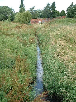
Holgate Beck is a small watercourse that flows north-eastwards through Holgate across the west side of the City of York, England. Primarily flowing through Holgate, from which it derives its name, the beck drains a large part of Askham Bog and Hob Moor, then running underneath the various lines near York railway station. It empties into the River Ouse at Water End, being one of five main tributaries for the River Ouse in York, and consequently added to the flooding in the river and immediate environs. To counter this, some flood diversionary schemes have been implemented near to Askham Bog and Hob Moor.

References

  1. "EYO63 – West Bank Park". her.york.gov.uk. Retrieved 23 August 2024.
  2. "West Bank Park – York". parksandgardens.org. Retrieved 23 August 2024.
  3. Ginley, Joanne (25 February 2014). "Park heritage centre plan to highlight story of 19th century garden pioneer". The Yorkshire Post. p. 13. ISSN   0963-1496.
  4. Cullen, Jane (13 June 2014). "Banking on future of city park". The York Press. p. 18. ISSN   1757-3289.
  5. Keogh, Luke (2020). The Wardian Case. Kew: Kew Publishing. p. 136. ISBN   978-1-84246-719-0.
  6. "West Bank Park". archaeologydataservice.ac.uk. Retrieved 24 August 2024.
  7. "P0335 West Bank Park, Holgate · York Archaeology Online Collections · Collections". collections.yorkarchaeologicaltrust.co.uk. Retrieved 11 September 2024.
  8. "Georeferenced Maps – Map images – National Library of Scotland". maps.nls.uk. Retrieved 11 September 2024. Use the slider on the bottom left (named "Change transparency of overlay") to toggle between old mapping and modern-day satellite imagery
  9. "West Bank Park Holgate". archaeologydataservice.ac.uk. Retrieved 11 September 2024.
  10. Hodgeson, Geoff (1999). A History of Holgate in five parts; part five, twentieth century Holgate. Rufforth: Hodgson. p. 64. ISBN   0-9527093-7-6.
  11. Pevsner, Nikolaus; Neave, David; Neave, Susan (2005). Yorkshire - York and the East Riding. London: Yale University Press. p. 261. ISBN   0300095937.
  12. Waterson, Edward (1990). Lost houses of York and the North Riding. York: Jill Raines. p. 63. ISBN   0-9516-4940-X.
  13. Hodgeson, Geoff (1999). A History of Holgate in five parts; part five, twentieth century Holgate. Rufforth: Hodgson. p. 65. ISBN   0-9527093-7-6.
  14. Lewis, Stephen (24 May 2019). "'There's a statue of Queen Victoria – get it sorted!'". York Press. Retrieved 17 September 2024.
  15. Dobson, Michaela (4 June 2018). "Queen Victoria Statue Conservation Completed". York Civic Trust. Retrieved 17 September 2024.
  16. Historic England. "Queen Victoria Statue (Grade II) (1256224)". National Heritage List for England . Retrieved 17 September 2024.
  17. "Jobs to go as city of York council budget agreed". BBC News. 1 March 2013. Retrieved 17 September 2024.
  18. "Gate Locking". westbankpark.org. 13 September 2017. Retrieved 17 September 2024.
  19. Turnbull, Catherine (11 December 2017). "Crime reduced at locked park". The York Press. p. 9.
  20. Jacob, Liana (19 October 2021). "Best parks in Yorkshire: 77 parks and canals in Yorkshire have been awarded the Green Flag status". The Yorkshire Post. Retrieved 23 August 2024.
  21. "About". westbankpark.org. 6 September 2017. Retrieved 23 August 2024.
  22. "Three York parks honoured with Green Flag awards". BBC News. 24 July 2024. Retrieved 23 August 2024.
  23. "Top 20 parks around York | First Bus". firstbus.co.uk. Retrieved 11 September 2024.
  24. "York Network map" (PDF). firstbus.co.uk. Retrieved 11 September 2024.
  25. "Top 20 parks around York | First Bus". firstbus.co.uk. Retrieved 17 September 2024.
  26. "Westbank Park". accessable.co.uk. Retrieved 11 September 2024.
  27. "West Bank Park play area – Parks and open spaces directory". york.gov.uk. Retrieved 16 September 2024.
  28. "About". westbankpark.org. 6 September 2017. Retrieved 17 September 2024.
  29. Lewis, Haydn (28 December 2022). "Girl becomes trapped in popular park as fire crews come to her rescue". The Northern Echo. Retrieved 17 September 2024.
  30. Catton, Richard (22 April 2009). "Anger over West Bank Park café closure". York Press. Retrieved 17 September 2024.
  31. "Council hopeful's plans for West Bank Park café". York Press. 13 March 2015. Retrieved 17 September 2024.