West Burleigh Store

Last updated

West Burleigh Store
West Burleigh Store 2 Burleigh Heads, Queensland.jpg
Building in 2015
Location33 Tallebudgera Creek Road, Burleigh Heads, Queensland, Australia
Coordinates 28°06′45″S153°26′28″E / 28.1125°S 153.4412°E / -28.1125; 153.4412
Design period1919–1930s (interwar period)
Built1935–1935
Official nameWest Burleigh Store, Flectcher's Store
Typestate heritage (built)
Designated5 December 2005
Reference no.602547
Significant period1930s (fabric)
1935–1980s (historical use as General Store)
Significant componentslead light/s, furniture/fittings, residential accommodation – manager's house/quarters
Australia Queensland location map.svg
Red pog.svg
Location of West Burleigh Store in Queensland
Australia location map.svg
Red pog.svg
West Burleigh Store (Australia)

West Burleigh Store is a heritage-listed general store at 33 Tallebudgera Creek Road, Burleigh Heads, Queensland, Australia. It was built from 1935 to 1935. It is also known as Flectcher's Store. It was added to the Queensland Heritage Register on 5 December 2005. [1]

Contents

History

The West Burleigh Store, constructed in 1935 during a property boom on the south coast stimulated by infrastructure development, is a substantial, timber two-storey shop house situated in a commercial precinct close to Tallebudgera Creek about 2.8 kilometres (1.7 mi) southwest of Burleigh Heads. Many of the original features of the store remain intact and it continues to be used as a retail outlet. [1]

Timber getting, agriculture and tourism stimulated the development of the Gold Coast region. Timber getters were among the earliest European inhabitants of the south coast and as late as the 1930s, Dennis' and Woods' sawmills were the stimulus for much of the development of West Burleigh. Closer settlement began in the 1860s, initially in the form of cotton plantations. The Crown Lands Alienation Act (1868) gave further impetus to small scale agriculture and by 1869, farmers and their households, numbering in the hundreds, populated the Mudgeeraba and Tallebudgera districts. With the decline of the cotton industry after the 1860s, these farmers diversified into other crops and dairying. In the decades between the World Wars, bananas and dairying were the major farming industries in the area. [1]

Campers and picnickers were attracted to the area as early as the 1870s by the natural beauty of the south coast beaches. Burleigh Heads was described in the Southern Queensland Bulletin in 1889 (2 March) as "a pretty place, a nice place for a gentleman's residence and a small seaside resort". Development of the coast as a destination for pleasure seekers was inhibited by poor access and inadequate infrastructure. This began to be remedied in 1889 with the opening of the railway to Southport and Nerang. Construction of an extension to Tweed Heads commenced in March 1901. A railway station was built at Booningba (renamed West Burleigh in 1914) about half an hour's buggy ride from Burleigh Heads. The Oyster Bed Hotel (1901) was built close to the station to service the wants and needs of the railway workers. The town's first store (still extant) located next to the hotel is believed to have been built in 1904 by Samuel Andrews. By 1907 the storekeeper, James Herbert, was delivering supplies to campers at Burleigh Heads. [1]

With the greater ownership of motorcars in the 1920s, road access became a key factor facilitating growth. The opening of the Jubilee Bridge (1925) and the coastal road and its extension south in 1926 promoted residential and holiday development along the coast especially at Burleigh Heads. In the 1930s, the construction of bridges over the Coomera River (1930) and Logan (1932) Rivers improved car access to the coast from Brisbane and a building and property boom ensued. Development was further stimulated by the provision of basic infrastructure: electricity was connected to Burleigh Heads in 1930 and extended to West Burleigh in 1934, a reticulated water supply was provided the following year. [1]

The West Burleigh Store and Post Office was completed in February 1935 during the boom period that followed these developments. Alf Fletcher had bought the town's existing general store business from J. Cuddihy in 1928. When the lease on the premises expired, Fletcher was required to move and the premises were taken over by another storekeeper. Fletcher built the new shop, West Burleigh's second general store, about 400 metres (1,300 ft) from the railway station. It was described in the South Coast Bulletin (15 February 1935) as a "large and up to date store" that, with its "modern conveniences", would be a "prominent link in the progress of the area". For its time, the store was a modern example of its type. [1]

Fletcher's new shop incorporated many features that were typical of general stores of the period. General stores were often large due to their profitableness and the increasingly diverse range of goods becoming available to consumers. The bi-coloured timber floor in the store was unusual and this, together with the conservative good quality of the building, reflected the prosperity of Fletcher's business and his expectation of commercial success. The large plate glass windows with a recessed entrance designed to maximize display space were a typical feature of interwar shops. The wooden box shelving (still extant) lining an inside wall was the recommended method for storing and displaying the increasing variety of packaged goods that were becoming available from the 1920s. These shelves are currently being used to display goods for sale. Counters (no longer extant) surrounded three walls and a large "U" shaped display area was located centrally between the counters. Petrol bowsers (no longer extant) were located under the verandah on the footpath. Many shops in the first half of the twentieth century also had on location the shop operator's residence; Fletcher's residence was located above the shop. Fletcher lived there with his parents and after they died, with his wife, Gussy, who he had employed in the shop. [1]

Fletcher operated the shop until his death in 1963 and the store continued to be operated by his widowed wife until the early 1970s. It stocked a wide range of goods including foodstuffs, haberdashery, manchester, clothes, boots, hardware, and building material. A large shed at the rear (extant until the 1980s or early 1990s) held livestock feed. The West Burleigh post office and telephone exchange was also conducted from the store. The post office was a smaller building attached to the northern side of the shop. It is believed that it was removed when the shopping and office complex was built around the shop in the 1980s. [1]

Alf Fletcher was a very well known local identity and his store was a focal point of West Burleigh's social and commercial life. Fletcher's customers were mainly the residents of Burleigh Heads and the farmlands of Tallebudgera, Nerang, Mudgeeraba, and Ingleside. The mailman or the cream and milk trucks that visited the surrounding dairies collected written orders and delivered boxes of goods on their return journeys. On Friday nights, local farm workers cashed their paychecks at Fletchers so they had cash to use at the local hotel. A former pupil of Ingleside State School recalls that Fletcher provided a bag of sweets for each child at the annual school break-up picnics. [1]

The West Burleigh store continued to be operated as a general store until the 1980s when the shopping complex around the store was developed. The ground floor of the shop was divided into two, one side operating as a real estate agent's office and the other as a saddlery. The second floor continued to be used as a residence until 2001. The residence was recently converted to office space. [1]

Description

Shop in 2015 West Burleigh Store Burleigh Heads, Queensland.jpg
Shop in 2015

The West Burleigh Store is a two-storey structure located in a retail shopping area in West Burleigh. The entrance to the building opens onto the footpath, the same being shaded by an overhanging enclosed verandah. It is about 10 metres (33 ft) wide and extends back from the footpath about 18 metres (59 ft). The verandah is enclosed with fibrous cement sheeting and the rest of the building is clad in weatherboard. A row of timber framed sliding windows runs the full length of the verandah. Each of these comprises a single, large square light bordered with frosted glass. Four square posts support the verandah. The corrugated iron roof is hipped at the rear and gabled at the front. A separate hipped roof covers the verandah. [1]

At the ground level, large plate glass display windows dominate the front of the store. The entrance to the shop is recessed and the plate glass windows continue around the sides of the entrance alcove. A decorative lead-light border made up of red, green and obscure glass runs the full length of the top of the windows. The rest of the shop front is clad with salmon and black ceramic tiles. [1]

The ground floor accommodates a real estate agent's office and a health food shop. The polished timber floor of the shop comprises dark timber planks alternated with light coloured timber. A set of timber box shelves extends the full length of the shop to the ceiling along the southern side. A recently installed counter runs along the opposite side. Commercial refrigerators are positioned along the rear of the shop. The ceiling is made up of fibrous cement sheeting with painted or stained timber battens laid out in a decorative pattern. [1]

Access to the upper storey is gained via a polished timber staircase. This part of the building accommodates offices. The floors of the upper storey are polished timber. Paneled internal doors or lighted French doors are used throughout with frosted glass or slatted wooden transoms. The original brass door and window furniture have been retained in most cases. The joinery is conservative in style and of good quality. [1]

The store is the most prominent structure in a complex of shops and offices dispersed around the large allotment. The commercial precinct surrounding this complex contains a number of historic buildings including West Burleigh's first general store located to the south of the existing West Burleigh store. [1]

Heritage listing

West Burleigh Store was listed on the Queensland Heritage Register on 5 December 2005 having satisfied the following criteria. [1]

The place is important in demonstrating the evolution or pattern of Queensland's history.

The West Burleigh Store provides physical evidence of an important stage in the development of the Gold Coast, one of the State's major tourist destinations. In the early 1930s, improved car access to the coast from Brisbane together with infrastructure development led to a building and property boom on the south coast. The store was completed in 1935 during this period. The erection of a substantial building with a good quality finish at a time when the nation was emerging from economic depression is indicative of the prosperity of the area at this time and storekeeper's expectations of future prosperity. As a substantially intact 1930s general store offering full service and a very wide range of goods and as a shop house, it is also important in demonstrating the evolution of retailing in Queensland. [1]

The place demonstrates rare, uncommon or endangered aspects of Queensland's cultural heritage.

The store is uncommon insofar that intact buildings from this period are becoming increasingly uncommon in the Gold Coast region. It also demonstrates a way of life that has become uncommon, namely the practice where storekeepers combined their shop and place of residence. [1]

The place is important in demonstrating the principal characteristics of a particular class of cultural places.

The store demonstrates many key aspects of 1930s general stores and shop houses. Considered to be a modern store for its era, many of its original fittings survive. The large display windows, recessed front entrance and the box shelves lining an internal wall are all features that were typical of general stores in the interwar period. The residence over the shop continued a long tradition in which a shopkeeper's home was combined with their place of work. This residence is also substantially intact. [1]

The place has a strong or special association with a particular community or cultural group for social, cultural or spiritual reasons.

The store has special association with many former and existing residents of the Gold Coast and for the tourists who visited the area during the decades that it operated as a general store. Built and originally operated by Alf Fletcher until his death in 1963, it continued in family ownership until the early 1970s. It was a focal point of West Burleigh township. Its customers included tourists and the residents of West Burleigh, Burleigh Heads, Tallebudgera, Nerang, Mudgeeraba, and Ingleside. Fletcher and his general store were very well known in the district. [1]

Related Research Articles

<span class="mw-page-title-main">Burleigh Heads, Queensland</span> Suburb of Gold Coast, Queensland, Australia

Burleigh Heads is a suburb in the City of Gold Coast, Queensland, Australia. In the 2016 census, Burleigh Heads had a population of 10,077 people.

<span class="mw-page-title-main">Mudgeeraba, Queensland</span> Suburb of City of Gold Coast, Queensland, Australia

Mudgeeraba is a town and suburb in the City of Gold Coast, Queensland, Australia. In the 2016 census, the suburb of Mudgeeraba had a population of 13,624 people.

<span class="mw-page-title-main">South Coast railway line, Queensland</span>

The South Coast railway line was a railway from Brisbane, the capital city of Queensland, Australia. The route via the South Coast to Tweed Heads on the border of Queensland and New South Wales. The line operated from 1889 to 1964. The Gold Coast railway line re-opened in 1996 along a modified alignment in the north and a new route south but does not extend as far south yet as the South Coast line.

<span class="mw-page-title-main">Tallebudgera Creek Dam</span> Dam in South East Queensland

The Tallebudgera Creek Dam, or colloquially Tally Dam, is a decommissioned embankment dam across the upper reaches of the Tallebudgera Creek, located in the South East region of Queensland, Australia. The initial purpose of the dam from its establishment until its decommissioning during the 1970s was for the supply of potable water to the Gold Coast region. There is no public access to the dam.

<span class="mw-page-title-main">Tallebudgera Creek</span> River in Queensland, Australia

The Tallebudgera Creek is a creek in South East Queensland, Australia. Its catchment lies within the Gold Coast local government area and covers an area of 98 square kilometres (38 sq mi). The river is approximately 25 kilometres (16 mi) in length and is known for good fishing.

<span class="mw-page-title-main">Gold Coast hinterland</span> Scenic area and region of South East Queensland, Australia

The Gold Coast hinterland is an area of South East Queensland, Australia that comprises the Tweed Range, Nimmel Range, Tamborine Mountain, Numinbah Valley, eastern parts of the McPherson Range and western parts of suburban Gold Coast, such as Mudgeeraba. This undefined unit of area is known for its tourist attractions including resorts, rainforest, lookouts, national parks, its diversity of fauna and flora and as a green backdrop to the coastal strip. It overlaps part of the Scenic Rim and is part of both the City of Gold Coast and Scenic Rim Region and includes Springbrook, Binna Burra and O'Reilly.

<span class="mw-page-title-main">Mitchell railway station</span> Historic site in Queensland, Australia

Mitchell railway station is located on the Western line in the Maranoa Region, Queensland, Australia. It serves the town of Mitchell. The station has one platform, opening in 1885. The station has a number of heritage-listed buildings, including the passenger station in Oxford Street, the goods shed in Alice Street, and the station master's house in Sheffield Street. The buildings were added to Queensland Heritage Register on 8 September 2005.

<span class="mw-page-title-main">Wiss House</span> Historic site in Queensland, Australia

Wiss House is a heritage-listed detached house at 7 Ann Street, Kalbar, Queensland, Australia. It was built from c. 1912 to 1940s. It was added to the Queensland Heritage Register on 26 August 1993.

<span class="mw-page-title-main">Wiss Brothers Store</span> Historic site in Queensland, Australia

Wiss Brothers Store is a heritage-listed shopping centre at 101 George Street, Kalbar, Queensland, Australia. It was built from 1890 to 1909. It was added to the Queensland Heritage Register on 29 October 1992. The building now houses The Emporium shopping experience, an extension of Empire Revival in Brisbane.

<span class="mw-page-title-main">Schmidt Farmhouse</span> Historic site in Queensland, Australia

Schmidt Farmhouse & Outbuildings is a heritage-listed homestead at 3 Worongary Road, Worongary, City of Gold Coast, Queensland, Australia. It was built from 1880s to c. 1910. It was added to the Queensland Heritage Register on 8 April 1997.

<span class="mw-page-title-main">Springbrook Road</span> Heritage-listed road in Queensland, Australia

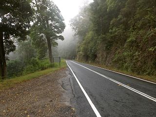
Springbrook Road is a heritage-listed road at Springbrook-Mudgeeraba Road, Springbrook, Gold Coast City, Queensland, Australia. It was built from 1925 to 1928. It is also known as Memorial Cairn, Springbrook-Mudgeeraba Road, and Toll Road. It is part of State Route 99. It was added to the Queensland Heritage Register on 22 October 1999. The road has been closed from Little Nerang Dam since Cyclone Debbie with repairs expected to be completed before 2019.

<span class="mw-page-title-main">Tallebudgera Post Office</span> Historic site in Queensland, Australia

Tallebudgera Post Office is a heritage-listed former post office at 17 Trees Road, Tallebudgera, Queensland, Australia. It was added to the Queensland Heritage Register on 1 October 2007.

<span class="mw-page-title-main">Windermere, Ascot</span> Historic site in Queensland, Australia

Windermere is a heritage-listed villa at 14 Sutherland Avenue, Ascot, Queensland, Australia. It was built from c. 1886 to 1930s. It was added to the Queensland Heritage Register on 21 October 1992.

<span class="mw-page-title-main">Woolloongabba Post Office</span> Historic site in Queensland, Australia

Woolloongaba Post Office is a heritage-listed former post office at 765 Stanley Street, Woolloongabba, City of Brisbane, Queensland, Australia. It was designed by Thomas Pye and built in 1905 by Thomas Rees. It is also known as Woolloongabba Post & Telegraph Office. It was added to the Queensland Heritage Register on 24 January 2003.

<span class="mw-page-title-main">Maryborough railway station, Queensland</span> Historic site in Queensland, Australia

Maryborough railway station is a heritage-listed railway station at Lennox Street, Maryborough, Fraser Coast Region, Queensland, Australia. It is on the North Coast line serving the city of Maryborough. It was designed by Chief Engineer of the Queensland Railways Department and built from 1878 to 1890 by John Roddam & John Walker. It was added to the Queensland Heritage Register on 21 October 1992.

<span class="mw-page-title-main">Waterford State School</span> Historic site in Queensland, Australia

Waterford State School is a heritage-listed state school at 40 Nerang Street, cnr Jordan Street, Waterford, City of Logan, Queensland, Australia. Block A was designed by Richard George Suter and built in 1871. It was added to the Queensland Heritage Register on 16 October 2008.

<span class="mw-page-title-main">Talgai Homestead</span> Historic site in Queensland, Australia

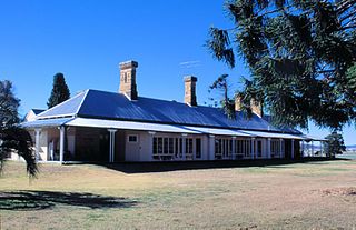
Talgai Homestead is a heritage-listed homestead at Allora, Southern Downs Region, Queensland, Australia. It was designed by architect Richard George Suter for Queensland pastoralist and politician George Clark and was built in 1868. It was added to the Queensland Heritage Register on 21 August 1992. It is also known as East Talgai Homestead to distinguish it from the West Talgai Homestead built by Clark's brother, Charles Clark. The homestead is now a private residence, owned by the Nioa family.

<span class="mw-page-title-main">Koongalba</span> Historic site in Queensland, Australia

Koongalba is a heritage-listed detached house at 12 Wharf Street, Yandina, Sunshine Coast Region, Queensland, Australia. It was built from 1894 to 1920s. It is also known as John Low's House. It was added to the Queensland Heritage Register on 4 July 1995.

<span class="mw-page-title-main">Halse Lodge</span> Historic site in Queensland, Australia

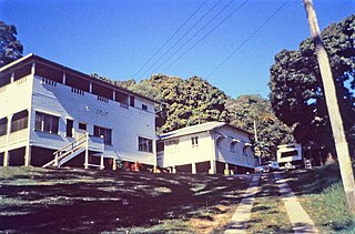
Halse Lodge is a heritage-listed boarding house at 17 Noosa Drive, Noosa Heads, Shire of Noosa, Queensland, Australia. It was built from 1880s to 1920s. It is also known as Bay View and Hillcrest Guest House. It was added to the Queensland Heritage Register on 30 April 1997.

<span class="mw-page-title-main">Ernest Junction railway tunnel</span> Historic site in Queensland, Australia

Ernest Junction railway tunnel is a heritage-listed former railway tunnel at 797 Ashmore Road, Molendinar, Gold Coast City, Queensland, Australia. It was built from 1885 to 1889 by the Queensland Railway Department. It was added to the Queensland Heritage Register on 3 May 2019.

References

  1. 1 2 3 4 5 6 7 8 9 10 11 12 13 14 15 16 17 18 19 20 "West Burleigh Store (entry 602547)". Queensland Heritage Register . Queensland Heritage Council. Retrieved 1 August 2014.

Attribution

CC-BY-icon-80x15.png This Wikipedia article was originally based on "The Queensland heritage register" published by the State of Queensland under CC-BY 3.0 AU licence (accessed on 7 July 2014, archived on 8 October 2014). The geo-coordinates were originally computed from the "Queensland heritage register boundaries" published by the State of Queensland under CC-BY 3.0 AU licence (accessed on 5 September 2014, archived on 15 October 2014).