
The West Essex Trail is a former railroad track bed of the Erie Lackawanna Railroad Caldwell Branch [1] now hiking trail located mostly in Essex County, New Jersey in the United States, [2] with a small section in Passaic County, New Jersey.
The West Essex Trail is a former railroad track bed of the Erie Lackawanna Railroad Caldwell Branch [1] now hiking trail located mostly in Essex County, New Jersey in the United States, [2] with a small section in Passaic County, New Jersey.
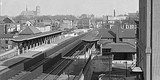
The northern trailhead is located where the Erie Lackawanna Caldwell Branch rail line split from the still active Montclair Branch. [3] Proceeding south the trail crosses County Route 612 in Little Falls at 0.2 miles. [4] One mile from the trailhead, the trail merges with the Lenape Trail before crossing Bowden Road. [4] At 1.5 miles the trail crosses the Peckman River [4] on the old railroad bridge before crossing Pompton Avenue (Route 23), where there are remnants [5] of the old Erie Railroad Cedar Grove Station [6] on the south side of the tracks [7] and stairs leading down to Pompton Avenue. The trail crosses Keeney Street in Verona at 2.4 miles. Just north of Keeney St was the Erie Railroad Overbrook Station. [8] Lastly the trail crosses Durrell Street in Verona, New Jersey at 2.7 miles before terminating at the southern trailhead located on Fairview Ave in Verona. [7] The rail bed continues through Verona passing under Bloomfield Avenue (the tunnel has since been filled in), Essex Fells and Roseland before rejoining active rail lines in Roseland at Interstate 280. [9] The trail is mixed use and available for walking, hiking, biking, and jogging. Along the trail one can find remnants of the old railroad line including mile markers, railroad ties, power lines, and signal boxes.


Essex County is located in the northeastern part of the U.S. state of New Jersey, and is one of the centrally located counties in the New York metropolitan area. As of the 2020 census, the county was the state's second-most populous county, with a population of 863,728, its highest decennial count since the 1970 census and an increase of 79,759 (+10.2%) from the 2010 census count of 783,969. The county is part of the North Jersey region of the state.

Route 23 is a state highway in the northern part of New Jersey, United States. The route runs 52.63 miles (84.70 km) from Bloomfield Avenue and Prospect Avenue (CR 577) in Verona, Essex County, northwest to the border with New York at Montague Township in Sussex County, where the road continues to Port Jervis, New York, as CR 15. Route 23 heads through Essex and Passaic counties as a two- to four-lane surface road and becomes a six-lane freeway north of a complex interchange with U.S. Route 46 (US 46) and Interstate 80 (I-80) in Wayne. The freeway carries Route 23 north to a concurrency with US 202. Past the freeway portion, the route heads northwest along the border of Morris and Passaic counties as a four- to six-lane arterial road with a wide median at places, winding through mountainous areas and crossing the interchange with I-287 in Riverdale. The route continues northwest through Sussex County as a mostly two-lane surface road that passes through farmland and woodland as well as the communities of Franklin, Hamburg, and Sussex before reaching the New York state line, just south of an interchange with I-84 and US 6 in Port Jervis, in Montague Township near High Point State Park.
Caldwell is a borough located in northwestern Essex County, in the U.S. state of New Jersey, about 16 miles (26 km) west of New York City and 6 miles (9.7 km) north-west of Newark, the state's most populous city. As of the 2020 United States census, the borough's population was 9,027, an increase of 1,205 (+15.4%) from the 2010 census count of 7,822, which in turn reflected an increase of 238 (+3.1%) from the 7,584 counted in the 2000 census.

Cedar Grove is a township in north central Essex County, in the U.S. state of New Jersey. As of the 2020 United States census, the township's population was 12,980, an increase of 569 (+4.6%) from the 2010 census count of 12,411, which in turn reflected an increase of 111 (+0.9%) from the 12,300 counted in the 2000 census.

Verona is a township in Essex County in the U.S. state of New Jersey. As of the 2020 United States census, the township's population was 14,572, an increase of 1,240 (+9.3%) from the 2010 census count of 13,332, which in turn reflected a decline of 201 (−1.5%) from the 13,533 counted in the 2000 census.
The Newark-Pompton Turnpike, is a roadway in northern New Jersey that was originally a tolled turnpike. The roadway was first laid out in the mid-18th century and given its name in 1806. As originally designed, it connected Newark with the area north and west of the Pompton River in what is now Riverdale. Its south end is Broadway in Newark; its north end is the Paterson-Hamburg Turnpike. As such, it was part of an alternate route between Newark and Paterson.

The Columbia Trail is a rail trail in rural northwestern New Jersey. It was created from portions of the former Central Railroad of New Jersey High Bridge Branch and stretches from High Bridge, in Hunterdon County, through Washington Township, in Morris County for a total of 15.1 miles (24.3 km). The trail surface is relatively flat and consists mostly of fine crushed stone.

Great Notch station was a small New Jersey Transit facility in the Great Notch section of Little Falls, New Jersey. The station was served seven times a day, three inbound morning trains to Hoboken Terminal and four outbound evening trains from Hoboken by the Montclair-Boonton Line from Monday to Friday. Located at the intersection of Notch Road and Long Hill Road, it was the second of three stations in Little Falls, the other two being Montclair State University and Little Falls and, after electrification, was the first on the line to be strictly served by diesel trains. However, most trains bypassed this station and continued on to Little Falls (westbound) and Montclair State University (eastbound). The station was served by a double track which ended west of the station. The last trains stopped at the station on January 15, 2010, at 7:41pm.

The Peckman River is a tributary of the Passaic River in Essex and Passaic Counties, New Jersey in the United States.
The Hilltop Reservation is a nature preserve located in Essex County, New Jersey, in the host communities of Caldwell, Cedar Grove, North Caldwell and Verona. It has over 200 acres (0.81 km2), and is the most recent addition to the Essex County Park System. It is composed of lands formerly occupied by the Essex Mountain Sanatorium, a hospital center originally constructed in the early 1900s to treat tuberculosis patients.
The Traction Line Recreation Trail is a multi-use paved asphalt rail trail located in Morristown, New Jersey.
The Lenape Trail is a trail through Essex County, connecting many county parks and reservations, wooded spaces, and historical sites. It begins in Newark, New Jersey and ends in Millburn, New Jersey. It was established in 1982. It is the fifth longest trail in the state behind the Delaware and Raritan Canal Trail, the Appalachian Trail, the completed section of the Highlands Trail in the state and the Batona Trail. The Lenape trail traverses Newark and its suburbs, as well as the Watchung Mountains and Passaic Meadows. Because of the steepness of the Watchung Mountains and the flood-prone nature of the Passaic Meadows, the former basin of Glacial Lake Passaic, these areas have remained much less developed than the rest of the northeastern part of the state. This trail therefore offers hikers an opportunity to see cultural and historical sites of an urban trail, as well as large natural and undeveloped areas. The trail's proximity to New York City and the various ridges it traverses, including Forest Hill, Orange Mountain, and Second Watchung Mountain, offer many views of the skyline. The Lenape Trail forms a segment of the Liberty-Water Gap Trail and incorporates the West Essex Trail, the Lenape Trail's only rail-to-trail section. The Lenape Trail also connects with Morris County's Patriots Path trail system on its western terminus.

The New York and Greenwood Lake Railway owned a line between Croxton, Jersey City, New Jersey and Greenwood Lake, New York. Service on the line was provided by the Erie Railroad.

The Montclair-Boonton Line is a commuter rail line of New Jersey Transit Rail Operations in the United States. It is part of the Hoboken Division. The line is a consolidation of three individual lines: the former Delaware, Lackawanna & Western Railroad's Montclair Branch, which ran from Hoboken Terminal to Bay Street, Montclair. The Erie Railroad's Greenwood Lake Division, a segment from Montclair to Mountain View-Wayne, originally ran from the Jersey City Terminal to Greenwood Lake, NY, and the former Lackawanna Boonton Line ran from Hoboken to Hackettstown, New Jersey.

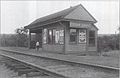
Verona station was a station on the Caldwell Branch of the Erie Railroad in Verona, New Jersey. The station was originally constructed in 1891 at the intersection of Depot Street and Personette Street by the Caldwell Railway, which was soon merged into the Erie Railroad system. The station burned down twice: the 1891 station depot burned down in 1905, and the second station survived until April 1, 1962, when arsonists destroyed it.

Essex Fells was the terminus of the Erie Railroad's Caldwell Branch in the Essex County community of Essex Fells, New Jersey. Located at the junction of Oak Lane and Chestnut Lane in Essex Fells, the station was also a connection to the Morristown and Erie Railroad, which continued west through Roseland towards Morristown. The next station north from the Essex Fells station was Caldwell heading northward to Great Notch in Little Falls, where the line connected to the New York and Greenwood Lake Railroad.

Caldwell station was the fourth of six stations on the Erie Railroad Caldwell Branch, located in Caldwell, New Jersey. The station was located on Bloomfield Avenue just north-east of Caldwell College. The station opened in 1891 as the terminus of the Caldwell Railroad, a branch of the New York and Greenwood Lake Railroad that forked off at Great Notch station in Little Falls, Passaic County.
Grove Street was a NJ Transit station in East Orange, Essex County, in the U.S. state of New Jersey, along the Morris & Essex Lines. The station was first built in 1901 by the Delaware, Lackawanna and Western Railroad (DL&W), and opened to the public in 1903. A second story was added to the eastbound station house after the DL&W elevated the tracks through East Orange in 1922. NJ Transit discontinued rail service to Grove Street on April 7, 1991. The entire station was demolished in 1995.

The Essex–Hudson Greenway is a planned state park and greenway in the northerneastern New Jersey counties of Essex and Hudson. It will follow an abandoned railroad right of way (ROW) across the New Jersey Meadowlands, over the Hackensack and Passaic rivers, as well pass through densely-populated neighborhoods. The nearly 9-mile (14 km) long shared-use linear park/rail trail will encompass about 135 acres (55 ha) and will average 100 feet (30 m) in width. Running between Jersey City and Montclair it will pass through Secaucus, Arlington in northern Kearny, North Newark, Belleville, Bloomfield and Glen Ridge. The initial phase in Newark and Kearny is expected to open in late 2025