West Grinstead railway station

Last updated

West Grinstead
West Grinstead Station.jpg
General information
Location West Grinstead, Horsham, West Sussex
England
Grid reference TQ184225
Platforms2
Other information
StatusDisused
History
Pre-grouping London, Brighton and South Coast Railway
Post-grouping Southern Railway
Southern Region of British Railways
Key dates
16 Sep 1861 [1] Opened
7 March 1966Closed

West Grinstead was a railway station on the Steyning Line which served the village of West Grinstead. It had a goods yard with a cattle loading bay and facilities for handling horse boxes. With the hunt kennels and national stud based in the area, the station saw substantial horse traffic. [2]

Contents

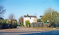
The station closed as a result of the Beeching Axe in 1966 and now forms part of the Downs Link footpath. The main station building and station worker's cottages, although now privately owned, remain, as do the station platforms. The local parish council have erected a replica station sign in the vicinity, and an old railway signal has also been installed. A British Railways Mark 1 coach has also been placed on rails in the former goods yard.

Preceding station Disused railways Following station
Southwater   British Rail
Southern Region

Steyning Line
  Partridge Green

See also

Related Research Articles

<span class="mw-page-title-main">Bluebell Railway</span> Heritage railway in England

The Bluebell Railway is an 11 mi (17.7 km) heritage line almost entirely in West Sussex in England, except for Sheffield Park which is in East Sussex. It is managed by the Bluebell Railway Preservation Society. It uses steam trains which operate between Sheffield Park and East Grinstead, with intermediate stations at Horsted Keynes and Kingscote.

<span class="mw-page-title-main">Spa Valley Railway</span> Heritage railway in southeast England

The Spa Valley Railway (SVR) is a standard gauge heritage railway that runs from Tunbridge Wells West railway station in Tunbridge Wells to High Rocks, Groombridge, and Eridge, where it links with the Oxted Line. En route it crosses Kent and East Sussex border, covering a distance of 5 miles (8 km), along the former Wealden Line between Tunbridge Wells Central and Lewes. The railway headquarters is also at Tunbridge Wells West railway station.

<span class="mw-page-title-main">Hackney Central railway station</span> London Overground station

Hackney Central is a London Overground station on the North London line in Hackney Central, Greater London. It lies between Dalston Kingsland and Homerton and is in Travelcard Zone 2. The station and all trains serving it are operated by National Rail services under the control of the London Rail division of Transport for London. However, there is no standard red National Rail "double arrow" logo signage at the station, instead only the Overground roundel.

<span class="mw-page-title-main">East Grinstead railway station</span> Railway station in West Sussex, England

East Grinstead railway station is one of the two southern termini of the Oxted line in the south of England and serves East Grinstead in West Sussex. It is 30 miles 4 chains from London Bridge, although trains mostly run to and from London Victoria. The station is managed by Southern.

<span class="mw-page-title-main">Worth Way</span>

The Worth Way is a 7-mile (11 km) footpath and bridleway linking the West Sussex towns of Crawley and East Grinstead via the village of Crawley Down. Mostly following the trackbed of a disused railway the path is an important wildlife corridor. It is part of the National Cycle Network.

<span class="mw-page-title-main">Tunbridge Wells West railway station</span> Station in Kent, England

Tunbridge Wells West is a railway station located in Royal Tunbridge Wells, Kent. It is one of two railway stations in Tunbridge Wells constructed by rival companies. The other, Tunbridge Wells Central was opened in 1845 by the South Eastern Railway (SER). Tunbridge Wells West was closed to mainline passenger services in 1985, but part of it still remains as a heritage railway line. Opened in 1996, it stands next to the original engine shed. The line is called the Spa Valley Railway.

<span class="mw-page-title-main">Ardingly railway station</span> Disused railway station in Ardingly, West Sussex

Ardingly was a railway station which served the West Sussex village of Ardingly in England. It was opened on 3 September 1883 by the London, Brighton and South Coast Railway (LBSCR) closed eighty years later and is currently used as an aggregates depot. The Bluebell Railway owns the trackbed from just east of the station to Horsted Keynes and has long-term plans to rebuild the line.

<span class="mw-page-title-main">West Hoathly railway station</span> Former railway station in England

West Hoathly is a closed railway station on what is now the Bluebell Railway. The station was closed in 1958, but was used by contractors demolishing the line in the 1960s to bring equipment in and out.

The Preston and Longridge Railway (P&LR) was a branch line in Lancashire, England. Originally designed to carry quarried stone in horse-drawn wagons, it became part of an ambitious plan to link the Lancashire coast to the heart of Yorkshire. The ambition was never achieved, but the line continued to carry passengers until 1930 and goods until 1967.

<span class="mw-page-title-main">Groombridge railway station</span> Station in East Sussex, England

Groombridge railway station is a station on the Spa Valley Railway (SVR) in Groombridge, East Sussex, England. Once a busy station serving four directions, it closed in 1985 to British Rail services. A new station the other side of Station Road bridge was opened by the SVR in 1997 as part of a standard gauge heritage railway to Tunbridge Wells West.

There are 22 disused railway stations in the 75 miles (121 km) between Bristol Temple Meads and Exeter St Davids, 12 of which have structures that can still be seen from passing trains. Most were closed in the 1960s but four of them, especially around Weston-super-Mare, were replaced by stations on new sites. 13 stations remain open on the line today, but there have been proposals to reopen stations at Cullompton and Wellington.

<span class="mw-page-title-main">Disused railway stations on the Exeter to Plymouth Line</span>

There are eleven disused railway stations between Exeter St Davids and Plymouth Millbay, Devon, England. At eight of these there are visible remains. Of the eleven stations, South Brent and Plympton are subject of campaigns for reopening while Ivybridge station was replaced by another station on a different site.

There are seventeen disused railway stations on the Cornish Main Line between Plymouth in Devon and Penzance in Cornwall, England. The remains of nine of these can be seen from passing trains. While a number of these were closed following the so-called "Beeching Axe" in the 1960s, many of them had been closed much earlier, the traffic for which they had been built failing to materialise.

The Three Bridges–Tunbridge Wells line is a mostly disused railway line running from Three Bridges in West Sussex to Tunbridge Wells Central in Kent via East Grinstead in West Sussex, a distance of 20 miles 74 chains (33.7 km). Opened in 1855, the main section of the line was a casualty of the Beeching Axe – the last train ran on 1 January 1967. The remaining section to Tunbridge Wells closed on 6 July 1985, although the section between Groombridge and Tunbridge Wells West was reopened in 1997 under the auspices of the Spa Valley Railway.

<span class="mw-page-title-main">Wantage Road railway station</span> Former railway station in England

Wantage Road railway station was a railway station on the Great Western Main Line in the Vale of White Horse district in Oxfordshire. The station was actually at the village of Grove, Oxfordshire, more than two miles north of Wantage. The station closed in December 1964 as part of the Beeching cuts.

<span class="mw-page-title-main">Selsdon railway station</span> Former railway station in England

Selsdon railway station was at the junction of the Croydon, Oxted and East Grinstead Railway and the now-closed Woodside and South Croydon Joint Railway. Opened in 1885 as "Selsdon Road" and it was 2 miles (3.2 km) from Selsdon village.

<span class="mw-page-title-main">Rudgwick railway station</span> Former railway station in England

Rudgwick railway station was on the Cranleigh Line. It served the village of Rudgwick in West Sussex until June, 1965.

<span class="mw-page-title-main">Dunstable North railway station</span> Former railway station in England

Dunstable North was a railway station on the London and North Western Railway's branch line from Leighton Buzzard which served Dunstable in Bedfordshire from 1848 to 1967. Originally the terminus of the London and North Western Railway's branch line from Leighton Buzzard, Dunstable became the point where the line met with the Great Northern's branch line from Luton in 1858. The station became the hub of a number of sidings connecting a variety of concerns to the line, including Waterlows, Bedfordshire County Council, Associated Portland Cement, Dunstable gasworks and a coal yard operated by the Great Northern. Against a background of falling passenger numbers and declining freight returns, the station closed to passengers in 1965 and to goods in 1967. Connections were retained with the cement works and coal yard, which became an oil depot, until 1988 and the line eventually closed in 1991. The site of the station is now occupied by offices of Central Bedfordshire Council. A section of the former line to the west of the site has become part of route 6 of the National Cycle Network.

<span class="mw-page-title-main">Chipping Norton railway station</span> Former railway station in Oxfordshire, England

Chipping Norton railway station served the town of Chipping Norton, Oxfordshire, England. The station had two platforms and a signal box.

<span class="mw-page-title-main">Globe Road & Devonshire Street railway station</span> Former railway station in England

Globe Road & Devonshire Street was a railway station on the Great Eastern Main Line, 1 mile 54 chains (2.7 km) down the line from Liverpool Street. It was opened by the Great Eastern Railway on 1 July 1884 when the company quadrupled the double-track main line section, and it was situated close to the site of the former Devonshire Street terminus, which had closed in 1840.

References

  1. "Index". Archived from the original on 17 June 2002. Retrieved 2 December 2016.
  2. West Sussex County Council Press Release, 6 June 2000

Coordinates: 50°59′22″N0°18′51″W / 50.9895°N 0.3143°W / 50.9895; -0.3143