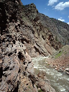
The Gunnison River is a tributary of the Colorado River, 164 miles (264 km) long, in the Southwestern state of Colorado. It is the largest tributary of the Colorado River in Colorado, with a mean flow of 2,570 cu ft/s (73 m3/s).

The Dolores River is a tributary of the Colorado River, approximately 241 miles (388 km) long, in the U.S. states of Colorado and Utah. The river drains a rugged and arid region of the Colorado Plateau west of the San Juan Mountains. Its name derives from the Spanish El Rio de Nuestra Señora de Dolores, River of Our Lady of Sorrows. The river was explored and possibly named by Juan Maria Antonio Rivera during a 1765 expedition from Santa Fe.

Roaring Fork River is a tributary of the Colorado River, approximately 70 miles (110 km) long, in west central Colorado in the United States. The river drains a populated and economically vital area of the Colorado Western Slope called the Roaring Fork Valley or Roaring Fork Watershed, which includes the resort city of Aspen and the resorts of Aspen/Snowmass.

The Blue River is a tributary of the Colorado River, approximately 65 miles (105 km) long, in the U.S. state of Colorado.

Animas River (an-e-muss) is a 126-mile-long (203 km) river in the western United States, a tributary of the San Juan River, part of the Colorado River System.

The Rio Chama, a major tributary river of the Rio Grande, is located in the U.S. states of Colorado and New Mexico. The river is about 130 miles (210 km) long altogether. From its source to El Vado Dam its length is about 50 miles (80 km), from El Vado Dam to Abiquiu Dam is about 51 miles (82 km), and from Abiquiu Dam to its confluence with the Rio Grande is about 34 miles (55 km).

The West Elk Mountains are a high mountain range in the west-central part of the U.S. state of Colorado. They lie primarily within the Gunnison National Forest, and part of the range is protected as the West Elk Wilderness. The range is primarily located in Gunnison County, with small parts in eastern Delta and Montrose counties.
The Cimarron River is a 22.0-mile-long (35.4 km) tributary that joins the Gunnison River in Curecanti National Recreation Area near Cimarron, Colorado. The river's source is the confluence of two forks near Silver Jack Reservoir in the Uncompahgre National Forest.

Elk River is a 34.2-mile-long (55.0 km) stream in Colorado. It flows from a confluence of the North Fork Elk River and Middle Fork Elk River in Routt National Forest north of Steamboat Springs to a confluence with the Yampa River.
The West Dolores River is a 35.0-mile-long (56.3 km) tributary of the Dolores River, in southwestern Colorado in the United States. Its source is northeast of Mount Wilson in the Lizard Head Wilderness of Dolores County, Colorado. The river flows southwest to a confluence with the Delores in Montezuma County.

The Roaring River is a 6.5-mile-long (10.5 km) tributary of the Fall River in Larimer County, Colorado. The river's source is Crystal Lake in the Mummy Range of Rocky Mountain National Park The river flows through Lawn Lake before a confluence with the Fall River in Horseshoe Park. The collapse of the Lawn Lake Dam in 1982 scoured the river's channel and deposited an alluvial fan of debris in Horseshoe Park.
East Mancos River is a 12.2-mile-long (19.6 km) tributary of the Mancos River in Montezuma County, Colorado. The river flows west from a source in the La Plata Mountains to a confluence with the West Mancos River that forms the Mancos River.

Lake Fork Gunnison River or Lake Fork is a 64.7-mile-long (104.1 km) tributary of the Gunnison River in Colorado. The river's source is Sloan Lake near Handies Peak in the San Juan Mountains of Hinsdale County. Lake Fork flows through Lake San Cristobal and Lake City before a confluence with the Gunnison River in Blue Mesa Reservoir.

South Fork Eagle River is a 6.9-mile-long (11.1 km) tributary of the Eagle River in Eagle County, Colorado. The river flows from a source east of Tennessee Pass in the White River National Forest to a confluence with the East Fork Eagle River that forms the Eagle River.
West Branch Laramie River is a 6.0-mile-long (9.7 km) tributary of the Laramie River in Larimer County, Colorado The river's source is Island Lake in the Rawah Wilderness. It flows through Carey Lake then northeast to a confluence with the Laramie River.
South Fork San Miguel River is a 6.5-mile-long (10.5 km) tributary of the San Miguel River in San Miguel County, Colorado. The river flows north from a confluence of the Lake Fork and the Howard Fork to a confluence with the San Miguel River west of Telluride.
North Fork Little Snake River is a 13.1-mile-long (21.1 km) tributary of the Little Snake River in Colorado and Wyoming. It flows from a source in the Medicine Bow National Forest of Carbon County, Wyoming to a confluence with the Middle Fork Little Snake River in Routt County, Colorado that forms the Little Snake River.
North Fork West Mancos River is a tributary of the West Mancos River in Montezuma County, Colorado. The river flows from a source east of Hesperus Mountain in the San Juan National Forest to a confluence with the South Fork that forms the West Mancos River.
South Fork West Mancos River is a tributary of the West Mancos River in Montezuma County, Colorado. The river flows from a source in the Owen Basin of the San Juan National Forest to a confluence with the North Fork that forms the West Mancos River.