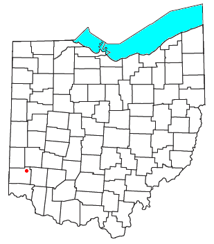
West Middletown is an unincorporated community in eastern Madison Township, Butler County, Ohio, United States. [1] It is located on the west shore of the Great Miami River about one mile from Middletown. It had about 200 people in 1905 and was formerly a station on the Cincinnati, Hamilton, and Dayton Railroad. Founded as Madison City, it received the name Heno when it was awarded a post office in 1882. Since there was already another Madison City in Ohio, the postmaster general demanded a name change. According to legend, as old-timers were discussing the new name around the cracker barrel in the general store, a can of Heno tea caught their attention. So the town was named for the tea. But in 1907, the postmaster general decreed the village was within the shadow of Middletown, and only a few postal workers had ever heard of Heno, making it difficult to sort and forward mail to the place. The government ordered the village to accept the name of West Middletown. In 1963 the postmaster general in another decree closed the West Middletown post office, transferring its business to Middletown.
In law, an unincorporated area is a region of land that is not governed by a local municipal corporation; similarly an unincorporated community is a settlement that is not governed by its own local municipal corporation, but rather is administered as part of larger administrative divisions, such as a township, parish, borough, county, city, canton, state, province or country. Occasionally, municipalities dissolve or disincorporate, which may happen if they become fiscally insolvent, and services become the responsibility of a higher administration. Widespread unincorporated communities and areas are a distinguishing feature of the United States and Canada. In most other countries of the world, there are either no unincorporated areas at all, or these are very rare; typically remote, outlying, sparsely populated or uninhabited areas.
Madison Township is one of thirteen townships in Butler County, Ohio, United States. Located in northeastern Butler County just west of Middletown, it had a population of 8,448 people as of the 2010 census, down from 8,611 in 2000. While it surrounds the city of Trenton, the city is no longer part of the township. It is named for James Madison, president of the United States at the time of its creation in 1810, and is one of twenty Madison Townships statewide.
Butler County is a county in the U.S. state of Ohio. As of the 2010 census, the population was 368,130. Its county seat is Hamilton. It is named for General Richard Butler, who died in 1791 during St. Clair's Defeat. Located along the Miami River, it is home to Miami University, an Ohio public university that was founded in 1809 as the second university in the State of Ohio.
Trenton is a city in northeastern Butler County, Ohio, United States, west of Middletown. Originally in Madison Township, it later annexed land in Wayne Township. The population was 11,869 at the 2010 census.
College Corner is a village in Butler and Preble counties in the southwestern part of the U.S. state of Ohio, 5 miles (8 km) northwest of Oxford. The population was 407 at the 2010 census.
Middletown is a city located in Butler and Warren counties in the southwestern part of the U.S. state of Ohio, about 29 miles northeast of Cincinnati. Formerly in Lemon, Turtlecreek, and Franklin townships, Middletown was incorporated by the Ohio General Assembly on February 11, 1833, and became a city in 1886.
Lemon Township is one of thirteen townships in Butler County, Ohio, United States. Located in the northeastern part of the county, it includes most of the city of Monroe. It had a population of 13,875 at the 2010 census. It is the only Lemon Township statewide.
Liberty Township is an affluent suburb of Cincinnati located in Butler County, Ohio. It is one of thirteen townships in Butler County, Ohio, United States. It is located on the east-central part of the county, just south of the city of Monroe. With an area of about 29 square miles (75 km2) it is smallest of the thirteen townships but one of the fastest growing areas in southwest Ohio, having a population of 37,259 at the 2010 census, up from 22,819 in 2000 and just 9,249 in 1990. It was named for Liberty, Pennsylvania, at the suggestion of John Morrow, a resident in the township at the time of its formation in 1803 who was the brother of Ohio Governor Jeremiah Morrow, after his hometown. The first settler was John Nelson, who arrived in 1796, seven years before Ohio became a state. It is one of 25 Liberty Townships statewide.
St. Clair Township, one of thirteen townships in Butler County, Ohio, United States, consists of three disconnected pieces located along the Great Miami River in central Butler County. It had a population of 6,908 at the 2010 census, down from 7,336 in 2000. Exclusive of the village of New Miami and the southern part of the village of Seven Mile, which lie within its borders, the unincorporated portion of St. Clair Township had 4,404 inhabitants in 2010.
Wayne Township, one of thirteen townships in the county, is located in north-central Butler County, Ohio, United States between Trenton and Oxford. It had a total population of 4,443 at the 2010 census, up from 4,252 in 2000. Exclusive of the two incorporated villages in the township, Jacksonburg and Seven Mile, Wayne Township had a population of 3,884 in 2010. It has an area of 36.6 square miles (94.9 km2), comprising one whole survey township in the Congress Lands.
Milford Township, one of thirteen townships in the county, is located in north-central Butler County, Ohio, United States, between Oxford and Middletown. The township had a population of 3,550 at the 2010 census, up from 3,254 in 2000. Excluding the now-defunct village of Somerville, 3,269 people lived in the unincorporated part of the township.
Bethany is an unincorporated community in southeastern Liberty Township, Butler County, Ohio, United States, located in the southwestern part of Ohio. It lies about three miles south of Monroe.
The "College Township" was the full survey township located in the northwest corner of Butler County, Ohio, now corresponding to the civil township of Oxford, designated by the Ohio General Assembly to be the site of the state university now called Miami University. When Congress, on May 5, 1792, authorized the sale to John Cleves Symmes of the land known as the Symmes Purchase, one of the terms was that he would allocate a full township of land to support a university, a promise he never fulfilled. The United States Congress subsequently allowed the State of Ohio to pick a township in the public domain for a college. They chose a township in the first range in the Congress Lands, namely R1E T5.
The Warren County Canal was a branch of the Miami and Erie Canal in southwestern Ohio about 20 miles (32 km) in length that connected the Warren County seat of Lebanon to the main canal at Middletown in the mid-19th century. Lebanon was at the crossroads of two major roads, the highway from Cincinnati to Columbus and the road from Chillicothe to the College Township (Oxford), but Lebanon businessmen and civic leaders wanted better transportation facilities and successfully lobbied for their own canal, part of the canal fever of the first third of the 19th century. The Warren County Canal was never successful, operating less than a decade before the state abandoned it.
Poast Town is an unincorporated community located in northeastern Madison Township, Butler County, Ohio, United States, on State Route 4, about one mile north of Middletown in Section 12 of T2R4 of the Congress Lands. It was laid out in 1818 by Peter Post as the town of West Liberty. A post office with the name Poast Town was established in 1848 but closed in 1934. Mail is provided through the Middletown post office, it is located in the Middletown telephone exchange. It is in the Madison Local School District.
Woodsdale is an unincorporated community in Madison and St. Clair Townships in central Butler County, Ohio, United States about three miles northeast of Hamilton. It was established in 1867 by the Beckett Paper Company and was formerly a stop on the Cincinnati, Hamilton, and Dayton Railroad. An electric generation plant of the Cincinnati Gas and Electric Company is located in Woodsdale. Woodsdale is also the location of the Samuel Augspurger House & Farm and The Augspurger Schoolhouse both of which are on the National Register of Historic Places.
Shandon is an unincorporated community in southeastern Morgan Township, Butler County, Ohio, United States. It is located on Paddy's Run, a tributary of the Great Miami River, about four miles west of Ross at the intersection of State Routes 126 and 748 in section 25 of R1ET3N of the Congress Lands. It was originally called Glendower as the town was settled by immigrants from Wales. It was later called New London and this survives in the names of Alert-New London and Hamilton-New London Roads. The town is in the Ross Local School District.
Okeana, originally known as Tariff, is an unincorporated community in central Morgan Township, Butler County, Ohio, United States. It is located on Dry Fork Creek, a tributary of the Great Miami River, on State Route 126 about three miles northwest of Shandon in sections 21 and 26 of R1ET3N of the Congress Lands. It is a mile north of Alert, a mile east of Macedonia, and ten miles southwest of Hamilton. The bulk of addresses served by the Okeana post office are in the Ross Local School District, but parts of the region are in the Southwest Local School District.
McGonigle is an unincorporated community in northwestern Hanover Township, Butler County, Ohio, United States about seven miles northwest of Hamilton at the intersection of U.S. Route 27 and State Route 130 in sections 17 and 18 of R2ET4N of the Congress Lands. It was formerly a stop on the Cincinnati, Hamilton, and Dayton Railroad's Indianapolis branch. It was named for Philip McGonigle, an early settler, and is spelled in various ways.
Port Union is an unincorporated community in western West Chester Township, Butler County, Ohio, United States on State Route 747 about three miles north of Springdale and three miles southeast of Hamilton. The town was laid out in 1827 by William Elliott alongside the turning basin for the Miami and Erie Canal and was about midway between Crescentville and Hamilton on the canal. It was originally known as McMaken's Bridge, but took the name its township.. The Cincinnati, Hamilton, and Dayton Railroad later laid tracks through Port Union.
Tylersville is an unincorporated community in central West Chester Township, Butler County, Ohio, United States. It was laid out in 1842 by Daniel Pocock and named for the President of the United States at the time, John Tyler. Its name lives on in a major road of northern West Chester Township, which is at Exit 22 on I-75.
Hamilton is a city in and the county seat of Butler County, Ohio, United States, in the state's southwestern corner, located 20 miles north of Cincinnati. The population was 62,447 at the 2010 census. The city is part of the Cincinnati metropolitan area. Hamilton has three designated National Historic Districts: Dayton Lane, German Village, and Rossville.
Fairfield Township, one of thirteen townships in Butler County, Ohio, United States, is located in the south central portion of the county. It had a population of 21,373 at the 2010 census, up from 15,571 in 2000, but down sharply from 49,353 in 1990 because of the withdrawal of the city of Fairfield in 1994 and annexations from Fairfield and Hamilton. Before annexations by the cities of Hamilton and Fairfield, it had an area of about 50 square miles (130 km2).
Coordinates: 39°31′25″N84°25′05″W / 39.52361°N 84.41806°W
A geographic coordinate system is a coordinate system that enables every location on Earth to be specified by a set of numbers, letters or symbols. The coordinates are often chosen such that one of the numbers represents a vertical position and two or three of the numbers represent a horizontal position; alternatively, a geographic position may be expressed in a combined three-dimensional Cartesian vector. A common choice of coordinates is latitude, longitude and elevation. To specify a location on a plane requires a map projection.
This Butler County, Ohio state location article is a stub. You can help Wikipedia by expanding it. |