
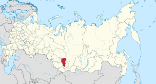
Novosibirsk Oblast is a federal subject of Russia located in southwestern Siberia. Its administrative and economic center is the city of Novosibirsk. The population was 2,788,849 as of the 2018 Census.
Kemerovo Oblast, also known as Kuzbass (Кузба́сс) after the Kuznetsk Basin, is a federal subject of Russia, located in southwestern Siberia, where the West Siberian Plain meets the South Siberian mountains. The oblast, which covers an area of 95,500 square kilometers (36,900 sq mi), shares a border with Tomsk Oblast in the north, Krasnoyarsk Krai and the Republic of Khakassia in the east, the Altai Republic in the south, and with Novosibirsk Oblast and Altai Krai in the west. Kemerovo is the administrative center of the oblast, though Novokuznetsk is the largest city in the oblast, in terms of size. Kemerovo Oblast is one of Russia's most urbanized regions, with over 70% of the population living in its nine principal cities. Its ethnic composition is predominantly Russian, but Ukrainians, Tatars, and Chuvash also live in the oblast. The population recorded during the 2010 Census was 2,763,135.

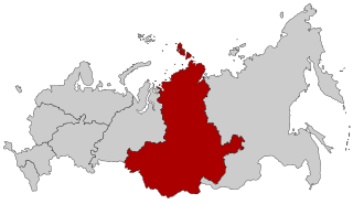
Krasnoyarsk Krai is a federal subject of Russia, with its administrative center in the city of Krasnoyarsk—the third-largest city in Siberia. Comprising half of the Siberian Federal District, Krasnoyarsk Krai is the largest krai in the Russian Federation, the second largest federal subject and the third largest subnational governing body by area in the world, after Sakha and the Australian state of Western Australia. The krai covers an area of 2,339,700 square kilometers (903,400 sq mi), which is nearly one quarter the size of the entire country of Canada, constituting roughly 13% of the Russian Federation's total area and containing a population of 2,828,187, or just under 2% of its population, per the 2010 Census.

The Russian Far East comprises the Russian part of the Far East, the eastermost territory of Russia, between Lake Baikal in Eastern Siberia and the Pacific Ocean.
Siberian Federal District is one of the eight federal districts of Russia. Its population was 17,178,298 according to the 2010 Census, living in an area of 4,361,800 square kilometers (1,684,100 sq mi). The entire federal district lies within the continent of Asia.

Altai Krai is a federal subject of Russia. It borders with the regions of, clockwise from the west, Kazakhstan, Novosibirsk and Kemerovo Oblasts, and the Altai Republic. The krai's administrative center is the city of Barnaul. As of the 2010 Census, the population of the krai was 2,419,755.
Barnaul is a city and the administrative center of Altai Krai, Russia, located at the confluence of the Barnaulka and Ob Rivers in the West Siberian Plain. As of the 2010 Census, its population was 612,401.

Chita is a city and the administrative center of Zabaykalsky Krai, Russia, located at the confluence of the Chita and Ingoda Rivers and on the Trans-Siberian Railway, 900 kilometers (560 mi) east of Irkutsk. Population: 324,444 (2010 Census); 316,643 (2002 Census); 365,754 (1989 Census).

Ussuriysk is a city in Primorsky Krai, Russia, located in the fertile valley of the Razdolnaya River, 98 kilometers (61 mi) north of Vladivostok, the administrative center of the krai, and about 60 kilometers (37 mi) from both the China–Russia border and the Pacific Ocean. Population: 158,004 (2010 Census); 157,759 (2002 Census); 158,016 (1989 Census).

Russia is divided into twelve economic regions —groups of federal subjects sharing the following characteristics:
Yeniseysk is a town in Krasnoyarsk Krai, Russia, located on the Yenisei River. Population: 18,766 (2010 Census); 20,394 (2002 Census); 22,891 (1989 Census); 20,000 (1970).

Lesozavodsk is a town in Primorsky Krai, Russia, located on the Ussuri River, 10 kilometers (6.2 mi) from the Sino–Russian border and about 300 kilometers (190 mi) north of Vladivostok, the administrative center of the krai. Population: 37,034 (2010 Census); 42,185 (2002 Census); 44,065 (1989 Census); 37,000 (1972). It was formerly known as Ussuri (Уссури).

East Siberian economic region is one of twelve economic regions of Russia.

Borzya is a town and the administrative center of Borzinsky District in Zabaykalsky Krai, Russia, located 349 kilometers (217 mi) southeast of Chita, the administrative center of the krai. Population: 31,379 (2010 Census); 31,460 (2002 Census); 36,373 (1989 Census).

Mogocha is a town and the administrative center of Mogochinsky District in Zabaykalsky Krai, Russia, located at the confluence of the Mogocha and Amazar Rivers, 709 kilometers (441 mi) northeast of Chita, the administrative center of the krai. Population: 13,258 (2010 Census); 13,282 (2002 Census); 17,847 (1989 Census).
The East Siberian Oblast was an early oblast of the Russian Soviet Federative Socialist Republic, which existed from December 5, 1936 to September 26, 1937. It was created when the East Siberian Krai was divided into the East Siberian Oblast and the Buryat Autonomous Soviet Socialist Republic in 1936 and ceased to exist after being split into the Irkutsk Oblast and the Chita Oblast in 1937.
Chegdomyn is an urban locality and the administrative center of Verkhnebureinsky District of Khabarovsk Krai, Russia. Population: 13,048 (2010 Census); 15,303 (2002 Census); 20,347 (1989 Census).

Yeniseysk Governorate was a governorate (guberniya) of the Russian Empire and later of the Russian Socialist Federative Soviet Republic.

Kulundinsky District is an administrative and municipal district (raion), one of the fifty-nine in Altai Krai, Russia. It is located in the west of the krai. The area of the district is 1,980 square kilometers (760 sq mi). Its administrative center is the rural locality of Kulunda. As of the 2010 Census, the total population of the district was 23,000, with the population of Kulunda accounting for 63.2% of that number.
Khilok is a town and the administrative center of Khiloksky District in Zabaykalsky Krai, Russia, located on the Khilok River, a right-hand tributary of the Selenga, 261 kilometers (162 mi) west of Chita, the administrative center of the krai. Population: 11,539 (2010 Census); 11,152 (2002 Census); 13,858 (1989 Census).

