
U.S. Route 33 (US 33) is a United States Numbered Highway that runs northwest–southeast for 709 miles (1,141 km) from northern Indiana to Richmond, Virginia, passing through Ohio and West Virginia en route. Although most odd-numbered U.S. routes are north–south, US 33 is labeled east–west throughout its route, except in Indiana where it is labeled north–south. It roughly follows a historic trail used by Native Americans from Chesapeake Bay to Lake Michigan.

U.S. Route 119 (US 119) is a spur of US 19. It is a north–south route that was an original United States highway of 1926. It is Corridor G of the Appalachian Development Highway System (ADHS) east of US 23 and KY 80 in Kentucky to Interstate 64 at Charleston, West Virginia.

West Virginia Route 45 is a state highway in the U.S. state of West Virginia. The state highway runs 25.8 miles (41.5 km) from the Virginia state line near Glengary east to WV 230 and WV 480 in Shepherdstown. WV 45 connects the communities of Glengary and Arden in southwestern Berkeley County with the county seat of Martinsburg. The state highway also connects Shepherdstown in northern Jefferson County with Martinsburg, where the highway meets Interstate 81 (I-81), U.S. Route 11, and WV 9.

West Virginia Route 2 is a state highway in the US state of West Virginia. It generally parallels the Ohio River along the western border of the state, from U.S. Route 60 in Huntington northeasterly to U.S. Route 30 in Chester.
West Virginia Route 44 is a north–south state highway located within Logan County, West Virginia. The southern terminus of the route is at U.S. Route 52 one mile south of Mountain View. The northern terminus is at West Virginia Route 73 in Logan. It is marked as the Jerry West Highway after the basketball player who had jersey 44.

West Virginia Route 51 is a state highway that runs west to east from Berkeley County to Jefferson County in West Virginia's Eastern Panhandle. The western terminus is at WV 45 northwest of Gerrardstown. The eastern terminus is at an interchange with U.S. Route 340 and WV 9 east of downtown Charles Town. US 340 continues to the east on the same roadway as WV 51.

West Virginia Route 4 is a north–south state highway within and maintained by the U.S. state of West Virginia. The southern terminus is at U.S. Route 119 in Clendenin. The northern terminus of the route is at West Virginia Route 20 in Rock Cave.

West Virginia Route 12 is a north–south route located in the southern portion of the U.S. state of West Virginia. The southern terminus of the route is at U.S. Route 219 in Peterstown, Monroe County, less than 300 yards (270 m) from the Virginia state line. It compromises a portion of the Farm Heritage Road byway between Peterstown and West Virginia Route 122. The northern terminus of the route is at U.S. Route 60 in Alta, Greenbrier County, near Interstate 64 exit 161.

West Virginia Route 34 is a north–south state highway in the U.S. state of West Virginia. The southern terminus of the route is at West Virginia Route 3 three miles (5 km) east of Hamlin. The northern terminus is at Interstate 77 exit 124 in Kenna.
West Virginia Route 37 is an east–west state highway in western West Virginia. The western terminus of the route is at the Kentucky state line in Fort Gay, where WV 37 becomes Kentucky Route 3 Spur upon crossing the Tug Fork. The eastern terminus is at West Virginia Route 10 one mile (1.6 km) south of Ranger.
West Virginia Route 88 is a north–south state highway located within the northern panhandle of West Virginia. The southern terminus is at U.S. Route 250 in Limestone. The northern terminus is at West Virginia Route 27 five miles east of Wellsburg and 400 yards (370 m) west of the Pennsylvania border.
West Virginia Route 622 is a north–south state highway located entirely in Kanawha County, West Virginia. The southern terminus of the route is at West Virginia Route 25 west of Institute. The northern terminus is at Interstate 77 exit 114 north of Pocatalico.

West Virginia Route 598 is a v-shaped state highway located entirely within Bluefield, West Virginia. The southern terminus of the route is at the Virginia state line, where WV 598 continues southward as Virginia State Route 598. The northern terminus of the route is at U.S. Route 52 in Bluefield.
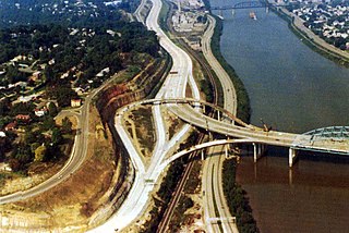
West Virginia Route 152 is a north–south state highway extending from Crum to Huntington, West Virginia. The northern terminus of WV 152 is unusual in that it also serves as the southern terminus of West Virginia Route 527, which continues along the same street as it passes over Interstate 64 at exit 8. WV 527 continues along the former routing of U.S. Route 52 through downtown Huntington, West Virginia on its way toward Chesapeake, Ohio. The southern terminus of the route is at US 52 northeast of Crum.

West Virginia Route 114 (WV 114) is a north–south state highway located in the Charleston, West Virginia area. The southern terminus of the route is at U.S. Route 60 east of downtown Charleston. The northern terminus of the route is at Interstate 79 (I-79) north of Big Chimney.

West Virginia Route 101 is an unsigned 1-mile (1.6 km) long north–south state highway in the City of Huntington in Cabell County, West Virginia. The southern terminus of the route is at U.S. Route 60. The northern terminus is at US 60.

Virginia State Route 311 and West Virginia Route 311 are adjoining state highways in the U.S. states of Virginia and West Virginia. The two state highways together run 58.7 miles (94.5 km) from U.S. Route 11 in Salem, Virginia north to Interstate 64 and U.S. Route 60 near White Sulphur Springs, West Virginia. The two Virginia portions of Route 311 are maintained by the Virginia Department of Transportation, with the exception of the city-maintained portion within Salem. The West Virginia segments are maintained by the West Virginia Division of Highways.

U.S. Route 52 (US 52) skirts the western fringes of the U.S. state of West Virginia. It runs from the Virginia state line near Bluefield, where it is concurrent with Interstate 77 (I-77), in a general northwest and north direction to I-64 at Kenova. There it turns east, overlapping I-64 for five miles (8.0 km) before splitting off onto the West Huntington Expressway into Ohio via the West Huntington Bridge. Despite having an even number, US 52 is signed north–south in West Virginia. In some other states along its route, it is signed east-west. The West Virginia segment is signed such that US 52 north corresponds to the general westward direction of the highway, and vice versa. For a while, US 52 parallels US 23, which is on the other side of the Big Sandy River in Kentucky. This continues into Ohio, where US 52 travels on the Ohio side of the Ohio River while US 23 travels on the Kentucky side.
The roads of Charleston, West Virginia, include three major interstate highways, several U.S. highways and state routes, and numerous major thoroughfares.

Pennsylvania Route 218 is a 13.5-mile-long (21.7 km) state highway and spur route of PA 18 located in Greene County, Pennsylvania. The southern terminus is at the West Virginia state line at Blacksville, WV, where the road continues into that state as West Virginia Route 218. The northern terminus is at U.S. Route 19 /PA 21 in Waynesburg, approximately 1 mile (1.6 km) east of PA 18.

