Interstate 79 (I-79) is an Interstate Highway in the Eastern United States, designated from I-77 in Charleston, West Virginia, north to Pennsylvania Route 5 (PA 5) and PA 290 in Erie, Pennsylvania. It is a primary thoroughfare through western Pennsylvania and West Virginia and makes up part of an important corridor to Buffalo, New York, and the Canada–United States border. Major metropolitan areas connected by I-79 include Charleston and Morgantown in West Virginia and Greater Pittsburgh and Erie in Pennsylvania.

Kanawha County is a county in the U.S. state of West Virginia. As of the 2020 census, the population was 180,745, making it West Virginia's most populous county. The county seat is Charleston, which is also the state capital and most populous city. Kanawha County is part of the Charleston, WV Metropolitan Statistical Area.

Interstate 64 (I-64) is an east–west Interstate Highway in the Eastern United States. Its western terminus is at I-70, U.S. Route 40 (US 40), and US 61 in Wentzville, Missouri. Its eastern terminus is at the Bowers Hill Interchange with I-264 and I-664 at Bower's Hill in Chesapeake, Virginia. I-64 connects Greater St. Louis, the Louisville metropolitan area, the Lexington–Fayette metropolitan area, the Charleston metropolitan area, the Greater Richmond Region, and Hampton Roads.

U.S. Route 60 is a major east–west United States highway, traveling 2,655 miles (4,273 km) from southwestern Arizona to the Atlantic Ocean coast in Virginia. The highway's eastern terminus is in Virginia Beach, Virginia, where it is known as General Booth Boulevard, just south of the city's Oceanfront resort district at the intersection of Rudee Point Road and Harbor Point. Its original western terminus was in Springfield, Missouri; it was then extended to Los Angeles, California, but in 1964, it was truncated to end southwest of Brenda, Arizona, at an interchange with Interstate 10 (I-10) after the US 60 highway designation was removed from California. I-10 replaced US 60 from Beaumont, California, to Arizona, and California State Route 60 (SR 60) replaced US 60 from Los Angeles to Beaumont.

The Kanawha River is a tributary of the Ohio River, approximately 97 mi (156 km) long, in the U.S. state of West Virginia. The largest inland waterway in West Virginia, its watershed has been a significant industrial region of the state since early in the 19th century.

U.S. Route 19 or U.S. Highway 19 (US 19) is a north–south United States Numbered Highway in the Eastern United States. Despite encroaching Interstate Highways, the route has remained a long-haul road, connecting the Gulf of Mexico with Lake Erie.

U.S. Route 35 (US 35) is a United States Highway that runs southeast-northwest for approximately 412 miles (663 km) from the western suburbs of Charleston, West Virginia to northern Indiana. Although the highway is physically southeast-northwest, it is nominally north–south. The highway's southern terminus is in Teays Valley, West Virginia, near Scott Depot, at Interstate 64 (I-64). Its northern terminus is near Michigan City, Indiana, at US 20. The West Virginia portion of the highway is mostly expressway, becoming a freeway shortly before it crosses the Ohio River into Ohio. The Ohio portion has been upgraded to a four-lane highway/freeway between the West Virginia state line and Trotwood, west of Dayton.

U.S. Route 119 (US 119) is a spur of US 19. It is a north–south route that was an original United States highway of 1926. It is Corridor G of the Appalachian Development Highway System (ADHS) east of US 23 and KY 80 in Kentucky to Interstate 64 at Charleston, West Virginia.
The James River and Kanawha Turnpike was built to facilitate portage of shipments of passengers and freight by water between the western reaches of the James River via the James River and Kanawha Canal and the eastern reaches of the Kanawha River.
In the United States, Corridor D is part of the Appalachian Development Highway System. In Ohio, it follows State Route 32 from the eastern Cincinnati suburbs until a point west of Albany, where it becomes concurrent with U.S. Route 50. After crossing into West Virginia, it follows U.S. Route 50 until the Interstate 79 interchange in Clarksburg.

West Virginia Route 62 is a north–south state highway in western West Virginia. The southern terminus of the route is at West Virginia Route 25 in Dunbar. The northern terminus is at Interstate 77 and U.S. Route 33 in Ripley.

West Virginia Route 480 is a 5.64-mile-long (9.08 km) state highway in the U.S. state of West Virginia. Known for most of its length as Kearneysville Pike, the highway extends from WV 115 in Kearneysville north to the Maryland state line at the Potomac River in Shepherdstown, from where the highway continues as Maryland Route 34. The route is one of the main north–south highways of northern Jefferson County and passes through the campus of Shepherd University. WV 480 was originally established in the early 1920s as West Virginia Route 48. The highway was paved in the mid-1920s, which included a different routing through Shepherdstown. WV 48's present routing through the town was established in the late 1930s when the first James Rumsey Bridge was completed; that bridge was replaced with the current bridge in the mid-2000s. WV 48 was renumbered to WV 480 in the mid-1970s after U.S. Route 48 was established in West Virginia and Maryland.

U.S. Route 52 (US 52) skirts the western fringes of the U.S. state of West Virginia. It runs from the Virginia state line near Bluefield, where it is concurrent with Interstate 77 (I-77), in a general northwest and north direction to I-64 at Kenova. There it turns east, overlapping I-64 for five miles (8.0 km) before splitting off onto the West Huntington Expressway into Ohio via the West Huntington Bridge. Despite having an even number, US 52 is signed north–south in West Virginia. In some other states along its route, it is signed east-west. The West Virginia segment is signed such that US 52 north corresponds to the general westward direction of the highway, and vice versa. For a while, US 52 parallels US 23, which is on the other side of the Big Sandy River in Kentucky. This continues into Ohio, where US 52 travels on the Ohio side of the Ohio River while US 23 travels on the Kentucky side.
U.S. Route 60 (US 60) runs northwest to southeast across the central and southern portions of West Virginia. It runs from the Kentucky state line at Catlettsburg, Kentucky, and Kenova. The road passes through Huntington, Charleston, and White Sulphur Springs. The route exits the state into Virginia, running concurrently with Interstate 64 (I-64) east of White Sulphur Springs. Most of US 60's route through West Virginia is part of and even signed in several areas as the Midland Trail, a National Scenic Byway.
The Charleston Metropolitan Statistical Area, as defined by the United States Census Bureau, is an area consisting of three counties in West Virginia, anchored by the city of Charleston. It is the largest metropolitan area entirely within the state of West Virginia. The Huntington Metro Area adds to the Charleston–Huntington, WV-OH-KY CSA and spans three states, while the core county of the Charleston area, Kanawha County, is more populous than the West Virginia portion of the Huntington area.

Interstate 77 (I-77) in the US state of West Virginia is a major north–south Interstate Highway. It extends for 187.21 miles (301.29 km) between Bluefield at the Virginia state line and Williamstown at the Ohio state line.

Interstate 64 (I-64) is an Interstate Highway in the US state of West Virginia. It travels east–west through the state for 189 miles (304 km) passing by the major towns and cities of Huntington, Charleston, Beckley, and Lewisburg.
West Virginia Route 869 is a short, one mile (1.6 km) state highway in Putnam County, West Virginia that connects U.S. Route 35 and West Virginia Route 62 via the Lower Buffalo Bridge over the Kanawha River. The route itself is unsigned on the bridge. The road was commissioned in 1998 to provide an alternate route for the fragile Winfield Bridge for trucks hauling goods for the Toyota Plant in Buffalo.
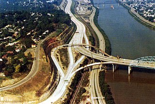
The roads of Charleston, West Virginia, include three major interstate highways, several U.S. highways and state routes, and numerous major thoroughfares.

Interstate 70 (I-70) is a portion of the Interstate Highway System that runs from near Cove Fort, Utah, at a junction with I-15 to Baltimore, Maryland. It crosses the Northern Panhandle of West Virginia through Ohio County and the city of Wheeling. This segment is the shortest of all states through which I-70 passes, crossing West Virginia for only 14.45 miles (23.26 km). The Fort Henry Bridge carries I-70 from Wheeling Island across the Ohio River and into downtown Wheeling before the freeway enters the Wheeling Tunnel. I-470, a southerly bypass of Wheeling and the lone auxiliary Interstate Highway in West Virginia, is intersected near Elm Grove. Before crossing into Pennsylvania, I-70 passes The Highlands, a major shopping center in the panhandle, and the Bear Rocks Lake Wildlife Management Area. On average, between 27,000 and 53,000 vehicles use the freeway every day.

