Related Research Articles

Westmorland is a historic county in North West England. It formed an administrative county between 1889 and 1974, after which the whole county was administered by the new administrative and ceremonial county of Cumbria. The people of Westmorland are known as Westmerians. In April 2023, it is planned that local government in Cumbria will be reorganised into two unitary authorities, one of which is to be named Westmorland and Furness and would cover all of the historic county along with parts of historic Yorkshire, Lancashire and Cumberland.
Cumberland is a historic county in North West England that had an administrative function from the 12th century until 1974. It is bordered by the historic counties of Northumberland to the north-east, County Durham to the east, Westmorland to the south-east, Lancashire to the south, and the Scottish counties of Dumfriesshire and Roxburghshire to the north. It formed an administrative county from 1889 to 1974 and now forms part of Cumbria. In April 2023, local government in Cumbria will be reorganised into two unitary authorities; one of these is to be named Cumberland and would include most of the historic county, with the exception of Penrith and the surrounding area.
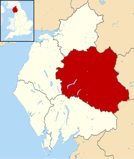
Eden is a local government district in Cumbria, England, based at Penrith Town Hall in Penrith. It is named after the River Eden, which flows north through the district toward Carlisle. Its population of 49,777 at the 2001 census, increased to 52,564 at the 2011 Census. A 2019 estimate was 53,253. In July 2021 it was announced that in April 2023, Cumbria will divide into two unitary authorities. Eden District Council will cease and its functions pass to a new authority, Westmorland and Furness, covering the current districts of Barrow-in-Furness, Eden and South Lakeland.

Wear Valley was, from 1974 to 2009, a local government district in County Durham, England. Its council and district capital was Crook.

Sedgefield District was, from 1974 to 2009, a local government district and, borough in County Durham, in North East England. It had a population of about 87,000. It was named after Sedgefield, but its largest town was Newton Aycliffe. Other places included Shildon, Ferryhill and Spennymoor.

Easington was, from 1974 to 2009, a local government district in eastern County Durham, England. It contained the settlements of Easington, Seaham, Peterlee, Murton, Horden, Blackhall, Wingate and Castle Eden. It did not however include Easington Lane which is administered as part of the City of Sunderland.
Penrith and The Border is a constituency in Cumbria represented in the House of Commons of the UK Parliament since 2019 by Neil Hudson, a Conservative.

Shap is a linear village and civil parish located among fells and isolated dales in Eden district, Cumbria, England, in the historic county of Westmorland. The parish had a population of 1,221 in 2001, increasing slightly to 1,264 at the 2011 Census.

Patterdale is a small village and civil parish in the eastern part of the English Lake District in the Eden District of Cumbria, in the traditional county of Westmorland, and the long valley in which they are found, also called the Ullswater Valley. The parish had a population of 460 in 2001, increasing to 501 at the 2011 Census.

Lakes is a large civil parish in the South Lakeland district of Cumbria, England. In the 2001 census the parish had a population of 5,127, decreasing at the 2011 census to 4,420. It covers the small town of Ambleside, and the villages and hamlets of Clappersgate, Rydal, Grasmere, Troutbeck, Chapel Stile, Elterwater, Little Langdale and Waterhead.
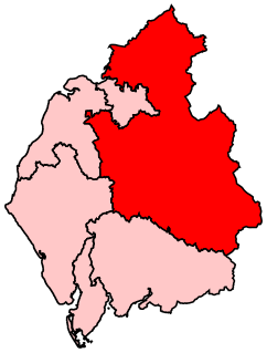
North Westmorland was a rural district in Westmorland, England from 1935 to 1974. It now forms part of the Eden district of Cumbria. It was formed in 1935 by the merger of the East Westmorland Rural District, Shap urban district and most of West Ward Rural District.

South Westmorland was a rural district in Westmorland, England from 1894 to 1974. It saw various boundary changes during its existence, particularly in 1935, when it absorbed Kirkby Lonsdale urban district, whilst parts merged with Ambleside and Grasmere Urban Districts to form Lakes Urban District at the same time. The district was abolished in 1974 under the Local Government Act 1972, with the area becoming part of the South Lakeland district of Cumbria.

The Barony of Kendal is a subdivision of the English historic county of Westmorland. It is one of two ancient baronies that make up the county, the other being the Barony of Westmorland. In 1974, the entire county became part of the modern county of Cumbria and ceased to have an administrative function. At the same time, Kendal borough along with some other rural and urban districts in Westmorland was merged with the neighbouring parts of Lancashire, Furness and Cartmel, and also the Sedbergh Rural District of the West Riding of Yorkshire into the new South Lakeland district of the new county.
The Barony of Westmorland also known as North Westmorland, the Barony of Appleby, Appleshire or the Bottom of Westmorland, was one of two baronies making up the English historical county of Westmorland, the other being the Barony of Kendal. Geographically, the barony covered the northern part of the larger county of the same name, and was divided into two wards – East Ward and West Ward. It covered an area similar to that of the Eden District of the new county of Cumbria, although it did not include Penrith, which is now the administrative capital of the district.
Leath was one of the wards of the historic county of Cumberland in north west England. Unlike most other English counties, Cumberland was divided into wards rather than hundreds.
Penrith was a rural district within the administrative county of Cumberland, England that existed from 1894 to 1974 with slight boundary changes in 1934.
East Westmorland was the name of a rural district in the administrative county of Westmorland from 1894 to 1935. The district was created by the Local Government Act 1894 based on the former East Ward rural sanitary district, and therefore indirectly on the former East Ward of Westmorland.

Shap Rural is a very large, but sparsely populated, civil parish in the Eden district of Cumbria in England, covering part of the Lake District National Park. It had a population of 119 in 2001, increasing to 130 at the 2011 Census.

The Wasdale Horseshoe is a group of hills on the eastern fringe of the English Lake District, to the west of the A6, south of Shap, Cumbria. They surround the valley of Wasdale Beck, a tributary of Birk Beck and ultimately of the River Lune. The horseshoe is the subject of a chapter of Wainwright's book The Outlying Fells of Lakeland. This Wasdale should not be confused with the better known Wasdale, containing Wast Water, on the west of the Lake District.
Birkbeck Fells is a township located in part of the parishes of Crosby Ravensworth, Orton and Shap in the historic county of Westmorland. It is a large mountainous district, and was described in the mid nineteenth century as containing around thirty scattered houses.
References
Coordinates: 54°33′50″N2°46′41″W / 54.564°N 2.778°W
| | This Cumbria location article is a stub. You can help Wikipedia by expanding it. |