Westerdok

Last updated
Westerdok
Native name
Dutch: Westerdok
Spoorwegmuseum Maquette omgeving Amsterdam Centraal Station - Westerdok.jpg
Model of the Westerdok in 1889
Location Amsterdam
Coordinates 52°23′08″N4°53′27″E / 52.385669°N 4.890928°E / 52.385669; 4.890928
Built1834
Location map Netherlands Amsterdam Central.png
Red pog.svg
Westerdok
Location of Westerdok in Amsterdam

Westerdok (Western Dock) is a former wet dock in Amsterdam. It was created in 1830-1834 by constructing the Westerdoksdam and Westerdoksluis, forming a reliable deep port closed off from the tidal IJ. It lost its function in 1876 when the North Sea Canal was opened. About half of it has since been filled up.

Contents

History

Westerdok in 2012 Westerdok001a.jpg
Westerdok in 2012
Westerdok the street. Westerdok.jpg
Westerdok the street.

Context

The construction of the wet dock Westerdok came about by the gradual silting up of the harbor of Amsterdam. For this background and the plans to build the Westerdok, see Oosterdok.

Construction

The Westerdoksdam was a 2,010 m long dyke constructed through the IJ from the west bank of the Haarlemmersluis in the Martelaarsgracht to the Spaarndammerdijk. [1] By July 1831, this dyke around the dock gave cover to ships lying in the proposed wet dock, but was far from complete. [2] By July 1834 the dyke was almost finished, an openinghad been left to allow shipping till the Westerdok Lock was completed. [3]

The foundation of the Westerdok Lock (Westerdoksluis) were started in 1830. The first pile was driven in on 21 July 1830. [4] Work on the foundations were delayed by weak and shifting grounds. [2] The commemorative stone of the lock was set on 19 September 1832. [1] The lock was first used on 19 September 1834, opening the Westerdok. [5]

Early significance as a harbor and wet dock

The Westerdok was a wet dock. It meant that inside the area closed off by the Westerdok Lock, the water level remained more or less constant. I.e. it was not influenced by the tides. The dock was also dredged out, so the largest Dutch ships could use it. The wet dock was very beneficial for shipping, because ships could much easier transload to boats and barges.

On the Westerdok about a dozen shipyards were situated on Bickerseiland. These profited by being able to launch bigger ships. Also on Bickerseiland was the sugar refinery Java of the Amsterdamsche Stoom Suikerraffinaderij. This would get a pier which allowed direct loading and unloading from ships in the Westerdok. The refinery burned down in 1874 and was not rebuilt.

A special feature of the Westerdok was Drydock II of the Rederij der Drijvende Droogdokken, a company that provided service by floating dry docks.

Decline of the port

The North Sea Canal

Railway closing in c. 1884 Buffa en Zonen, Afb KOKA00267000001.jpg
Railway closing in c. 1884

The North Sea Canal was constructed between 1865 and 1876. Part of its construction was the closure of the IJ on the east side by building the Oranje Locks. It meant that the whole IJ got the same characteristics as the Westerdok wet dock. Instead of protecting a safe harbor, the Westerdok Lock became an impediment to ships that wanted to unload in Amsterdam.

While the North Sea Canal would ultimately make the Westerdok obsolete, this was not the case for the Westerdoksdam. When the North Sea Canal was constructed, this dyke got some piers at which large ships could attach directly, instead of transloading to barges. This was a huge cost saver, which became even more significant when a cargo railway was constructed. [6] This railway used a bridge over the Westerdok Lock, see 1884 map.

Encroaching railways

In 1869 the municipal council of Amsterdam agreed with the government proposal to construct the future Amsterdam Centraal station on an island in the IJ between Westerdok and Oosterdok. In 1869 the municipal council of Amsterdam agreed to this location. [7] For the Westerdok, the railway plan was not so problematic as for the Oosterdok, because the main line lay south of the dock. The damage that the railway caused, was that the part of the dock east of a line between the Prinsengracht and the Westerdock was filled up to build the temporary Station Amsterdam Westerdok, a large railway roundhouse, and a classification yard.

By the 1910s, the Westerdok was no longer significant for shipping. The only use was by small coal barges and ships that came to repair at the Jonker and Suyver shipyards. The side of the Westerdok dyke that faced the IJ did remain important. The railways then decided to expand the central station, and to create Westerdokseiland, upon which a new classification yard would be constructed. A large part of the Westerdok was filled up with 650,000 m3 of sand. What was left of the Westerdok was a broad canal of 100 m width. [8] Along the new quay, the street Westerdok was constructed.

Current use

The current, much smaller Westerdok is home to many rather large barges that are used as houseboats. There is also a small marina.

Notes

  1. 1 2 Van der Vijver 1848, p. 160.
  2. 1 2 Opregte Haarlemsche Courant 9 July 1831.
  3. Algemeen Handelsblad 10 July 1834.
  4. Dagblad van 's Gravenhage 26 July 1830.
  5. Van der Vijver 1848, p. 164.
  6. Marhis 1878.
  7. Algemeen Handelsblad 25 June 1869.
  8. De locomotief 4 December 1919.

Related Research Articles

<span class="mw-page-title-main">Noordhollandsch Kanaal</span> Canal in the Northwest Netherlands

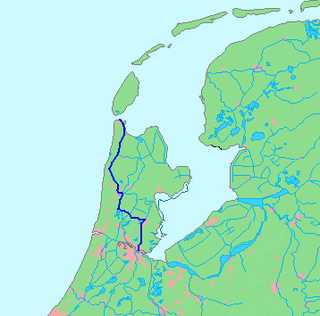
The Noordhollandsch Kanaal is a canal originally meant for ocean-going ships. It is located in North Holland, Netherlands. The canal was of great significance in Dutch history.

HNLMS <i>Cerberus</i> (1869)

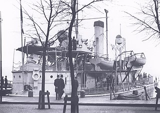
HNLMS Cerberus, was a Heiligerlee-class monitor built in Amsterdam for the Royal Netherlands Navy in the 1860s. Cerberus was a true monitor: a ship with shallow draught, only a few (heavy) guns and decent armor. These characteristics made her very suitable to operate way inland in the Dutch delta.

<i>Vesuvius</i>-class sloop

The Vesuvius class was a class of steam screw sloops of the Royal Netherlands Navy. The class comprised Vesuvius, Cornelis Dirks, Reinier Claessen, Het Loo, Reteh and Prinses Maria.

<i>Haarlemmermeer</i>-class gunvessel Former class of 9 gunvessels of the Royal Netherlands Navy

The Haarlemmermeer class was a class of nine gunvessels of the Royal Netherlands Navy. The class was a failure because of its extreme susceptibility to dry rot.

<span class="mw-page-title-main">Nederlandsche Scheepsbouw Maatschappij</span> Defunct Dutch shipbuilding company (1894-1946)

The Nederlandsche Scheepsbouw Maatschappij, was a Dutch shipbuilding company based in Amsterdam. It existed from 1894 to 1946. From c. 1908 it was the biggest Dutch shipbuilding company.

Tanjung Priok Dock of 4,000 tons

Tanjung Priok Dock of 4,000 Tons, was a floating dry dock built for Droogdok-Maatschappij Tandjong Priok in the 1890s.

Amsterdam Wooden Drydock I First floating dry dock of Amsterdam

Amsterdam Wooden Drydock I was the first floating dry dock of Amsterdam, and probably the first modern floating dry dock of Europe.

Amsterdam Wooden Drydock II Second floating dry dock of Amsterdam

Amsterdam Wooden Drydock II was the second floating dry dock of Amsterdam, and was moored in the Westerdok.

<span class="mw-page-title-main">Willem I Lock</span>

Willem I Lock is a monumental lock in Amsterdam-Noord.

<span class="mw-page-title-main">Koopvaarders Lock</span>

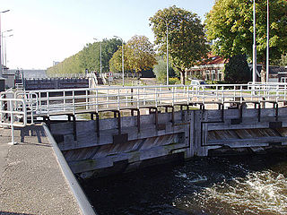
Koopvaarders Lock in Den Helder, Netherlands connects the Noordhollandsch Kanaal to the Nieuwediep. There were 4 locks at Nieuwediep carrying this name.

<span class="mw-page-title-main">Middelburg Drydock</span> Building in Zeeland, Netherlands

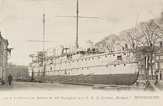
Middelburg Drydock is a former dry dock in Middelburg, Netherlands. The Dock chamber still exists.

<span class="mw-page-title-main">Amsterdamsche Droogdok Maatschappij</span> Dutch company

Amsterdamsche Droogdok Maatschappij (ADM) was a Dutch company that repaired ships using dry docks in Amsterdam, Netherlands. After World War II it also built some ships.

<span class="mw-page-title-main">Oosterdok</span> Historic site in Amsterdam

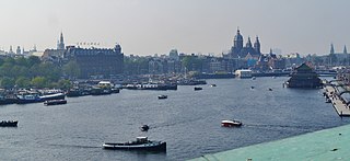
The Oosterdok is a former wet dock in Amsterdam. It was created in 1831-1832 by constructing the Oosterdoksdam and the Oosterdoksluis, forming a reliable deep port closed off from the tidal IJ.

<span class="mw-page-title-main">Oranje Locks</span> Water management facilities near Amsterdam, Netherlands

The Oranje Locks are a group of locks and other water management facilities just east of Amsterdam.

<span class="mw-page-title-main">L. Smit en Zoon</span> Dutch shipbuilding company (1791–1965)

L. Smit en Zoon previously known as Fop Smit, was a Dutch shipbuilding company located in Kinderdijk. Its successor is now part of Royal IHC.

<span class="mw-page-title-main">Nederlandsche Stoomboot Maatschappij</span> Transport company in Netherlands

The Nederlandsche Stoomboot Maatschappij ( ), abbreviated as NSM or NSBM, was a Dutch shipping line focused on inland navigation. In the 1820s it was important for the quick introduction of steam power on the Dutch rivers and on the Rhine. NSM owned the major shipbuilding company Fijenoord.

SS <i>De Batavier</i> (1827) Steamship

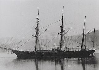
SS De Batavier, launched in 1827 was an early steamship which served on the Rotterdam to London line of the Nederlandsche Stoomboot Maatschappij (NSM). As such she was in news quite often, but the Batavier also appeared in fiction and non-fiction. The Batavier is the location of a chapter of Thackeray's Vanity Fair.

<span class="mw-page-title-main">Amsterdamsche Stoomboot Maatschappij</span> Transport company in the Netherlands

Amsterdamsche Stoomboot Maatschappij was an early Dutch steam shipping company.

<span class="mw-page-title-main">Amsterdamsche Stoom Suikerraffinaderij</span> 19th century Dutch sugar refining company

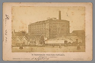
The Amsterdamsche Stoom Suikerraffinaderij was a big Dutch sugar refining company. It produced white sugar by refining raw sugar from sugar cane. The company existed from 1833 to 1875 and was one of the most important industrial companies of Amsterdam.

<span class="mw-page-title-main">Halfweg sugar factory</span>

The Halfweg sugar factory is a now defunct beet sugar factory previously known as "Suikerfabriek Holland". It closed down in 1992 and was then repurposed to become 'Sugar City', an area with offices, retail shops and an event venue. The terrain measures 11 hectares, and is hemmed in by the Haarlemmerstraatweg (N200), the Ringvaart of the Haarlemmermeer polder, and the wide part of the Ringvaart that leads to the sluices and the former Zijkanaal F. Halfweg village is on the other side of the wide part of the Ringvaart.

References