
The Georges River, also known as Tucoerah River, is an intermediate tide-dominated drowned valley estuary, that is located in Sydney in the state of New South Wales, Australia. The Georges River is located south and south-west from the Sydney CBD, with the mouth of the river being at Botany Bay.
Rail transport in Australia is a component of the Australian transport system. It is to a large extent state-based, as each state largely has its own operations, with the interstate network being developed ever since Australia's federation in 1901. As of 2022, the Australian rail network consists of a total of 32,929 kilometres (20,461 mi) of track built to three major track gauges: 18,007 kilometres (11,189 mi) of standard gauge, 2,685 kilometres (1,668 mi) of broad gauge, and 11,914 kilometres (7,403 mi) of narrow gauge lines. Additionally, about 1,400 kilometres (870 mi) of 610 mm / 2 ft gauge lines support the sugar-cane industry. 3,488 kilometres (2,167 mi), around 11 percent of the Australian heavy railways network route-kilometres are electrified.

The Main North Line is a major railway in New South Wales, Australia. It runs through Strathfield to Armidale. The line is the main line between Sydney and Armidale. As of 1988, the line closed progressively north of Armidale with services gradually withdrawn till 2004, with the main route between Sydney and Brisbane now the North Coast line. The end of these services marked a significant shift in rail transport in the region, leading to an increased reliance on road transport and altering the dynamics of movement and passenger accessibility between these major cities..

The Southern Sydney Freight Line (SSFL) is a freight only railway line in the south-western suburbs of Sydney, Australia. The line was built to segregate freight trains from the Sydney Trains network. It forms part of a dedicated freight only corridor between Port Botany and Macarthur. The line is managed by the Australian Rail Track Corporation.

The Australian Rail Track Corporation (ARTC) is an Australian Government-owned statutory corporation. It operates one of the largest rail networks in the nation, spanning 8,500 km across five states and 39 worksites.

Leightonfield railway station is a heritage-listed railway station located on the Main Southern line, serving the Sydney suburb of Villawood. It is served by Sydney Trains T3 Bankstown line services.
The Central Coast & Newcastle Line (CCN) is a NSW TrainLink passenger train service that runs along the Main North railway line in New South Wales, connecting the state's two largest cities, Sydney and Newcastle. The service runs from Central through to Broadmeadow on the Main North railway line to Newcastle Interchange on the Newcastle railway line, and services the Hawkesbury River region, the Central Coast and the city of Newcastle.

North Strathfield railway station is a heritage-listed railway station located on the Main Northern line, serving the Sydney suburbs of North Strathfield, North Homebush and Concord West. It is served by Sydney Trains' T9 Northern Line services.

Transport in Sydney is provided by an extensive network of public transport operating modes including metro, train, bus, ferry and light rail, as well as an expansive network of roadways, cycleways and airports. According to the 2006 census, in terms of travel to work or study Sydney has the highest rate of public transport usage among the Australian capital cities of 26.3% with more than 80% of weekday trips to/from Central Sydney being made by public transport. According to the New South Wales State Plan, the state has Australia's largest public transport system. The public transport network is regulated by Transport for NSW.
The Sydney Freight Network is a network of dedicated railway lines for freight in Sydney, Australia, linking the state's rural and interstate rail network with the city's main yard at Enfield and Port Botany. Its primary components are the Southern Sydney Freight Line (SSFL) and a line from Sefton to Enfield and Port Botany. The Network has been managed by the Australian Rail Track Corporation (ARTC) since 2012. Prior to the completion of the SSFL, it was managed by RailCorp as the Metropolitan Freight Network.

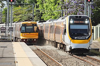
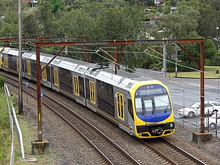
Sydney, the largest city in Australia, has an extensive network of passenger and goods railways. The passenger system includes an extensive suburban railway network, operated by Sydney Trains, a metro system and a light rail network. A dedicated goods network also exists.

The South West Rail Link is a railway line serving the developing suburbs of south-western Sydney, Australia between Glenfield and Leppington. Services form part of the Sydney Trains suburban rail network. It opened on 8 February 2015.

An extensive multi-modal transport system serves the state of New South Wales, Australia. The lead government agency responsible for the network's operation and development is Transport for NSW.

The 81 class are a class of diesel locomotives built by Clyde Engineering, Kelso for the State Rail Authority.

The Bombala railway line is a branch railway line in the south of New South Wales, Australia. The northern part of it forms part of the main line from Sydney to Canberra, but the southern part is closed. It branches off the Main South line at Joppa Junction, south of Goulburn. The line is used by NSW TrainLink Xplorer services running between Sydney Central and Canberra station.

The rail network of Melbourne, Australia, has a significant number of railway lines and yards serving freight traffic. Rail transport in Victoria is heavily focused on Melbourne, and, as a consequence, much of the state's rail freight passes through the metropolitan network.
The Adelaide–Port Augusta railway line is the main route for northbound rail traffic out of Adelaide, South Australia. The line, 315 kilometres long, is part of the Adelaide–Darwin rail corridor and the Sydney–Perth rail corridor.
The Northern Sydney Freight Corridor (NSFC) was a project to improve access between Sydney and Newcastle for freight trains. Frequent passenger services operate on the Main Northern line between Strathfield and Broadmeadow. These passenger services take priority, meaning freight trains can be delayed and are subject to a curfew during peak hours. The Northern Sydney Freight Corridor aimed to reduce delays and increase capacity by providing additional train paths. The delivery of the NSFC projects was managed by Transport for NSW, with the exception of the Hexham freight loop which was delivered in June 2012 by the Australian Rail Track Corporation. The final stage was completed in June 2016.

The Sydney Region Outline Plan (SROP) was a land use and infrastructure scheme for metropolitan New South Wales released by the State Planning Authority in March 1968. The SROP superseded the 1948 County of Cumberland planning scheme. Whereas the Cumberland scheme echoed contemporary plans for London, the SROP adopted a Scandinavian model of town centres arranged along existing railway corridors.
The 2010s saw many developments relating to transport in the Australian city of Sydney. The decade saw a substantial investment in infrastructure, including a new airport, motorway projects, light rail lines, Australia's first metro system, the new Waratah fleet and the demise of the non-air conditioned S sets from the rail network. Planning and branding of public transport services became substantially more centralised.

