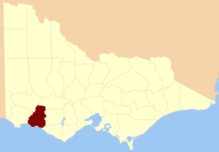
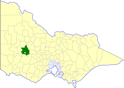
Ararat Rural City is a local government area in Victoria, Australia, located in the western part of the state. It covers an area of 4,211 square kilometres (1,626 sq mi) and in June 2018 had a population of 11,795.

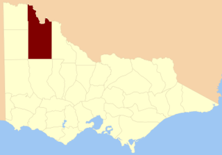
The Shire of Southern Grampians is a local government area (LGA) in the Barwon South West region of Victoria, Australia, located in the south-western part of the state. It covers an area of 6,654 square kilometres (2,569 sq mi) and in June 2018 had a population of 16,135. It includes the towns of Coleraine, Hamilton, Dunkeld and Penshurst. It was formed in 1994 from the amalgamation of the City of Hamilton, Shire of Wannon and parts of the Shire of Dundas, Shire of Kowree, Shire of Mount Rouse and Shire of Heywood.

The Division of Wannon is an Australian Electoral Division in the state of Victoria.

As with any such statistic, there are a number of claims for the title "the longest bar in Australia":

The Australian wine industry is one of the world's largest exporters of wine, with approximately 800 million out of the 1.2 to 1.3 billion litres produced annually exported to overseas markets. The wine industry is a significant contributor to the Australian economy through production, employment, export, and tourism.
The County of Villiers is one of the 37 counties of Victoria which are part of the cadastral divisions of Australia, used for land titles. It includes the area to the north of Warrnambool, and to the west of the Hopkins River. The county was proclaimed in 1849.
The County of Karkarooc is one of the 37 counties of Victoria which are part of the cadastral divisions of Australia, used for land titles. It is located to the south of the Murray River, with its western boundary at 142°E, and its eastern boundary at 143°E. Its southern boundary is on the 36°S parallel. Lake Tyrrell is located near the eastern boundary. Mildura is located near the north-western edge.
Murray Darling is a wine region and Australian Geographical Indication which spans the Murray River and its confluence with the Darling River in northwestern Victoria and southwestern New South Wales. It was registered as a protected name on 16 June 1997.
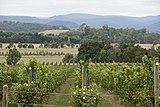
The Grampians is an Australian wine region located in the state of Victoria, west of Melbourne. It is located near the Grampians National Park and the Pyrenees hills. The area is dominated by red wine production, particularly Shiraz and Cabernet Sauvignon.

The Shire of Warracknabeal was a local government area about 200 kilometres (124 mi) west-northwest of Bendigo and 60 kilometres (37 mi) north of Horsham, in western Victoria, Australia. The shire covered an area of 1,839 square kilometres (710.0 sq mi), and existed from 1891 until 1995.
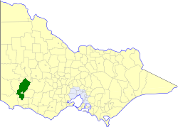
The Shire of Dundas was a local government area about 300 kilometres (186 mi) west of Melbourne, the state capital of Victoria, Australia. The shire covered an area of 3,464.39 square kilometres (1,337.6 sq mi), and existed from 1857 until 1994.

The Shire of Mount Rouse was a local government area about 270 kilometres (168 mi) west of Melbourne, the state capital of Victoria, Australia. The shire covered an area of 1,407 square kilometres (543.2 sq mi), and existed from 1860 until 1994.
The Shire of Stawell was a local government area about 230 kilometres (143 mi) west-northwest of Melbourne, the state capital of Victoria, Australia. The shire covered an area of 2,606 square kilometres (1,006.2 sq mi), and existed from 1861 until 1995.
The City of Hamilton was a local government area about 300 kilometres (186 mi) west of Melbourne, the state capital of Victoria, Australia. The city covered an area of 20.64 square kilometres (8.0 sq mi), and existed from 1859 until 1994. Its area was surrounded by the Shire of Dundas.

The County of Dundas is one of the 37 counties of Victoria which are part of the cadastral divisions of Australia, used for land titles. The county is in the Western District of Victoria bounded by the Glenelg River in the west and north, by a line from Casterton to Penshurst in the south, and by the eastern edge of the Grampians in the east. Larger towns include Hamilton, Casterton and Coleraine. The county was proclaimed in 1849.
Maroona is the junction station between what is the main western railway line and the branch line to Portland, Victoria, Australia. A number of sidings are provided at this station which are still in use. The platform and station building remain at Maroona with track access still available to one side of the platform.

Ararat was an electoral district of the Legislative Assembly in the Australian state of Victoria. The electorate was abolished in 1904 and replaced by the electoral district of Stawell and Ararat.

Aboriginal sites of Victoria form an important record of human occupation for probably more than 40,000 years. They may be identified from archaeological remains, historical and ethnographic information or continuing oral traditions and encompass places where rituals and ceremonies were performed, occupation sites where people ate, slept and carried out their day to day chores, and ephemeral evidence of people passing through the landscape, such as a discarded axe head or isolated artefact.
The Royal Mail Restaurant is a Modern Australian restaurant in rural Dunkeld, Victoria connected to the Royal Mail Hotel. The chef de cuisine is Robin Wickens, who took over from Dan Hunter in 2013. Hunter had previously worked at Mugaritz and is now at Brae.
Stawell was an electoral district of the Legislative Assembly in the Australian state of Victoria from 1877 to 1904. It centred on the town of Stawell in western Victoria.