The cultivation of peat bogs and moors as of 1000 BC led to subsidence, which necessitated the building of dykes. The Westfriese Omringdijk was formed by connecting a large number of smaller dykes. This was completed by 1250 AD, just in time for the area to be spared annihilation in the St. Lucia's flood of 1287. The total dyke length is about 126 km, protecting an area of about 800 km2. It connects the cities of Enkhuizen, Hoorn, Alkmaar, Schagen, Medemblik and then back to Enkhuizen.
Holland is a geographical region and former province on the western coast of the Netherlands. From the 10th to the 16th century, Holland proper was a unified political region within the Holy Roman Empire as a county ruled by the counts of Holland. By the 17th century, the province of Holland had risen to become a maritime and economic power, dominating the other provinces of the newly independent Dutch Republic.
A levee, dike, dyke, embankment, floodbank, or stop bank is a structure used to keep the course of rivers from changing and to protect against flooding of the area adjoining the river or coast. It is usually earthen and often runs parallel to the course of a river in its floodplain or along low-lying coastlines.
Lelystad is a municipality and a city in the centre of the Netherlands, and it is the capital of the province of Flevoland. The city, built on reclaimed land, was founded in 1967 and was named after Cornelis Lely, who engineered the Afsluitdijk, making the reclamation possible. Lelystad is approximately 3 metres below sea level.
The IJsselmeer, also known as Lake IJssel in English, is a closed-off inland bay in the central Netherlands bordering the provinces of Flevoland, North Holland and Friesland. It covers an area of 1,100 km2 (420 sq mi) with an average depth of 4.5 m (15 ft). The river IJssel flows into the IJsselmeer.
Frisia is a cross-border cultural region in Northwestern Europe. Stretching along the Wadden Sea, it encompasses the north of the Netherlands and parts of northwestern Germany. The region is traditionally inhabited by the Frisians, a West Germanic ethnic group.
Enkhuizen is a municipality and a city in the Netherlands, in the province of North Holland and the region of West-Frisia.
Stede Broec is a municipality in the Netherlands, in the province of North Holland and the region of West-Frisia. The name Stede Broec derives from stede and broec.
East Frisia or East Friesland is a historic region in the northwest of Lower Saxony, Germany. It is primarily located on the western half of the East Frisian peninsula, to the east of West Frisia and to the west of Landkreis Friesland.
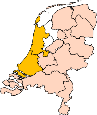
West Friesland is a contemporary region in the Northwest of the Netherlands, in the province of North Holland.
Wieringerwaard is a polder and a village in the municipality of Hollands Kroon in the Dutch province of North Holland. Wieringerwaard was formerly a separate municipality, until it merged with Barsingerhorn in 1970.
The Christmas Flood of 1717 was the result of a northwesterly storm, which hit the coast area of the Netherlands, Germany, and Scandinavia on Christmas night of 1717. In total, about 14,000 people drowned.
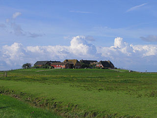
A terp, also known as a wierde, woerd, warf, warft, werf, werve, wurt or værft, is an artificial dwelling mound found on the North European Plain that has been created to provide safe ground during storm surges, high tides and sea or river flooding. The various terms used reflect the regional dialects of the North European region.
St. Lucia's flood (Sint-Luciavloed) was a storm tide that affected the Netherlands and Northern Germany on 13/14 December 1287 (OS), St. Lucia Day and the day after, killing approximately 50,000 to 80,000 people in one of the largest floods in recorded history.
West Frisia is a term that, when used in an international context, refers to the traditionally Frisian areas that are located west of the Dollart. Along with East Frisia and North Frisia, it is one of the most commonly used subdivisions of Frisia. In its narrowest sense, the term is synonymous with the province of Friesland. Within the Netherlands, however, it is mostly used to refer to the region of West Friesland, located west of Friesland.
Aartswoud is a village in the Dutch province of North Holland, part of the municipality of Opmeer. It lies about twelve kilometres (7.5 mi) northeast of Heerhugowaard.
The Leybucht is the second largest bay in East Frisia in northwest Germany after the Dollart. The Jade Bight is larger than both, but belongs historically to Oldenburg.
Kreil is a hamlet in the Dutch province North Holland, it is located on the Westfriese Omringdijk in the municipality Hollands Kroon.
The Zuiderkerk, also called Sint-Pancraskerk is a late Gothic hall church in Enkhuizen, in the Netherlands, currently used by the Protestant Church in the Netherlands.
Frisian nationalism refers to the nationalism which views Frisians as a nation with a shared culture. Frisian nationalism seeks to achieve greater levels of autonomy for Frisian people, and also supports the cultural unity of all Frisians regardless of modern-day territorial borders. The Frisians derive their name from the Frisii, an ancient Germanic tribe which inhabited the northern coastal areas in what today is the northern Netherlands, although historical research has indicated a lack of direct ethnic continuity between the ancient Frisii and later medieval 'Frisians' from whom modern Frisians descend. In the Middle Ages, these Frisians formed the Kingdom of Frisia and later the Frisian freedom confederation, before being subsumed by stronger foreign powers up this day.
This page is based on this Wikipedia article Text is available under the CC BY-SA 4.0 license; additional terms may apply. Images, videos and audio are available under their respective licenses.