Westminster House, Manchester

Last updated

Westminster House, Manchester
Westminster House, Portland Street, Manchester.jpg
Westminster House
Greater Manchester UK location map 2.svg
Red pog.svg
Westminster House
Location within Greater Manchester
General information
AddressPortland Street, Manchester
Country United Kingdom
Coordinates 53°28′47″N2°14′11″W / 53.4796°N 2.2364°W / 53.4796; -2.2364 Coordinates: 53°28′47″N2°14′11″W / 53.4796°N 2.2364°W / 53.4796; -2.2364
Completed1973
Design and construction
Architect(s) Fitzroy Robinson & Partners

Westminster House is a commercial facility on the south east side of Portland Street, Manchester. As "County Hall", it was the headquarters of Greater Manchester County Council from its formation in April 1974 to its abolition in March 1986.

History

In the mid-19th century the site on the south east side of Portland Street had been occupied by a row of residential and retail properties which included the Portland Street Silk Mill; the area in the next block to the south east of the site (on the south east side of Major Street) was known at that time as Westminster Place and this may have been, in part, the origin of the name. [1] [2] The site itself continued to be occupied by the same aging residential and retail properties until the mid-20th century. [3]

The building, which was designed by Fitzroy Robinson & Partners and built at the cost of £4.5 million (£40,160,000 as of 2023), [4] was completed in 1973. [2] The design for the seven-storey building involved a main frontage on Portland Street with wings stretching back along Minshull Street and Aytoun Street; the ground floor was designated for retail use and the windows on the first floor were slightly recessed; the upper floors featured a continuous bands of glazing with red brick above and below the glazing. [2]

The building was acquired for use as the headquarters of Greater Manchester County Council on the county council's formation in April 1974. [5] [6] It was originally referred to as County Hall and, although the county council officers and their departments were based at County Hall, the full county council would meet at Manchester Town Hall. [7] The building was vacated by Greater Manchester County Council on its abolition in March 1986. [2]

In 1988 the building was sold for circa £5 million to Parc Securities who refurbished it and converted it for commercial use. [7] It was then sold on, in 1990, for circa £22 million to County Hall Properties who renamed it "Westminster House"; it was suggested in The Independent that this may have been, in part, to honour the Westminster Government of Margaret Thatcher which had abolished the Greater Manchester County Council. [7] The building was later acquired by Aviva Investors, [8] who commissioned an extensive programme of refurbishment works costing £18 million which were carried out by contractors, Styles & Wood, to a design by BDP and completed in summer 2017. [9] [10] [11] Following completion of the refurbishment works, the building was renamed again, this time simply to 11 Portland Street. [12] [13]

Notable residents as of 2022 include Arm Limited. [14]

Related Research Articles

<span class="mw-page-title-main">Greater Manchester</span> County of England

Greater Manchester is a metropolitan and ceremonial county in North West England, with a population of 2.8 million, comprising ten metropolitan boroughs: Manchester, Salford, Bolton, Bury, Oldham, Rochdale, Stockport, Tameside, Trafford and Wigan. The county was created on 1 April 1974, as a result of the Local Government Act 1972, and has been covered by a combined authority on 1 April 2011. Greater Manchester was created from parts of the historic counties of Cheshire, Lancashire and Yorkshire.

<span class="mw-page-title-main">Metropolitan Borough of St Marylebone</span> Metropolitan borough of England

The Metropolitan Borough of St Marylebone was a metropolitan borough of the County of London from 1900 to 1965. It was based directly on the previously existing civil parish of St Marylebone, which was incorporated into the Metropolitan Board of Works area in 1855, retaining a parish vestry, and then became part of the County of London in 1889.

<span class="mw-page-title-main">Manchester Town Hall</span> Municipal building in Manchester, England

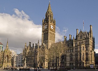
Manchester Town Hall is a Victorian, Neo-gothic municipal building in Manchester, England. It is the ceremonial headquarters of Manchester City Council and houses a number of local government departments. The building faces Albert Square to the north and St Peter's Square to the south, with Manchester Cenotaph facing its southern entrance.

<span class="mw-page-title-main">Manchester city centre</span> Central Business District in England

Manchester City Centre is the central business district of Manchester, England, within the confines of Great Ancoats Street, A6042 Trinity Way, and A57(M) Mancunian Way, which collectively form an inner ring road. The City Centre ward had a population of 17,861 at the 2011 census.

<span class="mw-page-title-main">Rochdale</span> Town in Greater Manchester, England

Rochdale is a town in Greater Manchester, England, at the foothills of the South Pennines in the dale of the River Roch, 5 miles (8.0 km) northwest of Oldham and 10 miles (16.1 km) northeast of Manchester. It is the administrative centre of the Metropolitan Borough of Rochdale, which had a population of 211,699 in the 2011 census.

<span class="mw-page-title-main">Milnrow</span> Human settlement in England

Milnrow is a town within the Metropolitan Borough of Rochdale, in Greater Manchester, England. It lies on the River Beal at the foothills of the South Pennines, and forms a continuous urban area with Rochdale. It is 2 miles (3.2 km) east of Rochdale town centre, 10 miles (16.1 km) north-northeast of Manchester, and spans from Windy Hill in the east to the Rochdale Canal in the west. Milnrow is adjacent to junction 21 of the M62 motorway, and includes the village of Newhey, and hamlets at Tunshill and Ogden.

<span class="mw-page-title-main">Middleton, Greater Manchester</span> Town in Greater Manchester, England

Middleton is a town in the Metropolitan Borough of Rochdale, Greater Manchester, England, on the River Irk 5 miles (8.0 km) southwest of Rochdale and 5 miles (8.0 km) northeast of Manchester city centre. Middleton had a population of 42,972 at the 2011 Census. It lies on the northern edge of Manchester, with Blackley to the south and Moston to the south east.

<span class="mw-page-title-main">Greater Manchester County Council</span> Local government administrative body for Greater Manchester from 1974 to 1986

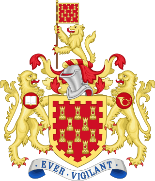
The Greater Manchester County Council (GMCC) was the top-tier local government administrative body for Greater Manchester from 1974 to 1986. A strategic authority, with responsibilities for roads, public transport, planning, emergency services and waste disposal, it was composed of 106 directly elected members drawn from the ten metropolitan boroughs of Greater Manchester. The Greater Manchester County Council shared power with ten lower-tier district councils, each of which directed local matters. It was also known as the Greater Manchester Council (GMC) and the Greater Manchester Metropolitan County Council (GMMCC).

<span class="mw-page-title-main">Heywood, Greater Manchester</span> Human settlement in England

Heywood is a town in the Metropolitan Borough of Rochdale, Greater Manchester, England, in the historic county of Lancashire. It had a population of 28,205 at the 2011 Census. The town lies on the south bank of the River Roch, 2 miles (3.2 km) east of Bury, 4 miles (6.4 km) southwest of Rochdale, and 8 miles (12.9 km) north of Manchester. Middleton lies to the south, whilst to the north is the Cheesden Valley, open moorland, and the Pennines. Heywood's nickname is Monkey Town.

<span class="mw-page-title-main">Paddington Waterside</span> Development in London, England

Paddington Waterside is a developed area around Paddington Station in London.

<span class="mw-page-title-main">Alkrington</span> Human settlement in England

Alkrington Garden Village is a suburban area of Middleton, in the Metropolitan Borough of Rochdale, Greater Manchester England.

<span class="mw-page-title-main">Grade II* listed buildings in Greater Manchester</span>

There are 236 Grade II* listed buildings in Greater Manchester, England. In the United Kingdom, the term listed building refers to a building or other structure officially designated as being of special architectural, historical or cultural significance; Grade II* structures are those considered to be "particularly significant buildings of more than local interest". In England, the authority for listing under the Planning Act 1990 rests with English Heritage, a non-departmental public body sponsored by the Department for Culture, Media and Sport.

<span class="mw-page-title-main">Marylebone</span> Area in London, England

Marylebone is a district in the West End of London, in the City of Westminster. Oxford Street, Europe's busiest shopping street, forms its southern boundary.

<span class="mw-page-title-main">Rochdale Town Hall</span> Municipal building in Rochdale, Greater Manchester, England

Rochdale Town Hall is a Victorian-era municipal building in Rochdale, Greater Manchester, England. It is "widely recognised as being one of the finest municipal buildings in the country", and is recorded in the National Heritage List for England as a designated Grade I listed building. The Town Hall functions as the ceremonial headquarters of Rochdale Metropolitan Borough Council and houses local government departments, including the borough's civil registration office.

<span class="mw-page-title-main">Grade I listed buildings in Greater Manchester</span>

There are 48 Grade I listed buildings in Greater Manchester, England. In the United Kingdom, the term listed building refers to a building or other structure officially designated as being of special architectural, historical or cultural significance; Grade I structures are those considered to be "buildings of exceptional interest". In England, the authority for listing under the Planning Act 1990 rests with Historic England, a non-departmental public body sponsored by the Department for Culture, Media and Sport.

<span class="mw-page-title-main">Westminster City Hall</span> Municipal building in London, England

Westminster City Hall is a municipal building in Victoria Street in Westminster, London. It is the headquarters of Westminster City Council.

<span class="mw-page-title-main">Marylebone Town Hall</span> Municipal building in London, England

Marylebone Town Hall, also known as the Westminster Council House, is a municipal building on Marylebone Road in Marylebone, London. The complex includes the council chamber, the Westminster Register Office and an educational facility known as the Sammy Ofer Centre. It is a Grade II listed building.

<span class="mw-page-title-main">Bury Town Hall</span> Municipal building in Bury, Greater Manchester, England

Bury Town Hall is a municipal building in Knowsley Street, Bury, Greater Manchester, England. The town hall, which is the headquarters of Metropolitan Borough of Bury, is a locally listed building.

<span class="mw-page-title-main">Dukinfield Town Hall</span> Municipal building in Dukinfield, Greater Manchester, England

Dukinfield Town Hall is a municipal building in King Street, Dukinfield, Greater Manchester, England. The town hall, which was the headquarters of Dukinfield Borough Council, is a grade II listed building.

<span class="mw-page-title-main">Royton Town Hall</span> Municipal building in Royton, Greater Manchester, England

Royton Town Hall is a municipal building in Rochdale Road, Royton, Greater Manchester, England. The town hall was the headquarters of Royton Urban District Council.

References

  1. "Ordnance Survey Map". 1951. Retrieved 29 October 2020.
  2. 1 2 3 4 "Westminster House - Portland Street". Manchester History. Retrieved 6 October 2019.
  3. "Ordnance Survey Map". 1965. Retrieved 29 October 2020.
  4. UK Retail Price Index inflation figures are based on data from Clark, Gregory (2017). "The Annual RPI and Average Earnings for Britain, 1209 to Present (New Series)". MeasuringWorth. Retrieved 11 June 2022.
  5. "Greater Manchester". The Times . 7 November 1975.
  6. Rochdale Metropolitan Borough Council. Metropolitan Rochdale Official Guide. London: Ed. J. Burrow & Co. Limited. p. 65.
  7. 1 2 3 "End of the metropolitan line: County councils face an uncertain future". The Independent. 13 August 1992. Retrieved 6 October 2019.
  8. "Aviva cracks on with Westminster House revamp". Place North West. 16 September 2015. Retrieved 14 November 2020.
  9. "Styles&Wood wins £17.7m contract to refurbish Westminster House on Portland Street, Manchester". Manchester Evening News. 30 September 2015. Retrieved 6 October 2019.
  10. "Westminster House". Premier Construction News. 5 July 2016. Retrieved 14 November 2020.
  11. "Styles&Wood wins £18m Manchester office refurbishment". The Construction Index. 16 September 2015. Retrieved 14 November 2020.
  12. "11 Portland Street, Manchester" (PDF). Savills. Retrieved 29 October 2020.
  13. "Tenant doubles space at Portland Street". Place North West. 9 January 2019. Retrieved 14 November 2020.
  14. "Arm Manchester Office". Arm Ltd. Retrieved 10 May 2022.