Related Research Articles

The Hutt Valley is the large area of fairly flat land in the Hutt River valley in the Wellington region of New Zealand. Like the river that flows through it, it takes its name from Sir William Hutt, a director of the New Zealand Company in early colonial New Zealand.

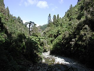
Kaitoke, part of Upper Hutt City, is a locality in the southern North Island of New Zealand. It is located at the northern end of the Hutt Valley, 45 kilometres northeast of Wellington City and six kilometres from the northern end of the Upper Hutt urban area. It also lies at the southern end of the Tararua Ranges.

Barton's Bush, in Trentham Memorial Park, is the largest remaining area of lowland mixed podocarp/broadleaf forest in the Hutt Valley of New Zealand. Named after Richard Barton who settled in the area in 1841, it was his desire that this section of the native forest should remain whilst the city of Upper Hutt gradually took shape and land was cleared for farming and settling.

The Akatarawa River is a river in the lower North Island of New Zealand.

Silverstream is a suburb of Upper Hutt in New Zealand, just under 7 km south-west of the Upper Hutt CBD. It is in the lower (southern) part of the North Island of New Zealand at the southern end of Upper Hutt, close to the Taitā Gorge, which separates Upper Hutt from Lower Hutt. The area is sited at the mouth of a small valley formed by the Wellington Region's tectonic activity and, in part, by Hull's Creek, which discharges into the Hutt River.
The Wellington Racing Club (WRC) is a racing horse racing club based at Trentham Racecourse in Trentham, Wellington, New Zealand.

Alicetown is a central suburb of Lower Hutt located at the bottom of the North Island of New Zealand.
The Royal Wellington Golf Club, founded in 1895, is one of New Zealand's most beautiful and historic golf courses. The Golf Club is situated in Heretaunga, Upper Hutt, just north of Wellington and alongside the Hutt River between Silverstream and Trentham.
The Eastern Hutt River is a river of New Zealand. It flows southwest from the Tararua Range to join with the Western Hutt River and become the Hutt River, a major river of the southern North Island.
The Little Akatarawa River is a river of the Wellington Region of New Zealand's North Island. It is a tributary of the Akatarawa River, which it meets 5 kilometres (3 mi) northwest of Te Mārua.

The Mangaroa River is a river of the Wellington Region of New Zealand's North Island. It flows north from the western foothills of the Remutaka Range to the west of Lower Hutt, meeting with the Hutt River on the northern outskirts of Upper Hutt.

The Mangatāwhiri River is a river of the Auckland and Waikato regions of New Zealand's North Island. It flows generally southwest from its sources in the Hunua Ranges southeast of Clevedon before flowing through a system of irrigation canals at the northern edge of the Waikato Plains close to the town of Pōkeno. It reaches the Waikato River close to the township of Mercer.

The Pākuratahi River, previously the Pakuratahi River, is a river of the Wellington Region of New Zealand's North Island. It flows northwest from its source in the Remutaka Range 15 kilometres (9 mi) east of Lower Hutt to join the Te Awa Kairangi / Hutt River near Kaitoke.
The Western Hutt River is a river of New Zealand. It flows generally southwards from the Tararua Range to join with the Eastern Hutt River and become the Hutt River, a major river of the southern North Island.
The Whakatahine River is a river of the Wellington Region of New Zealand's North Island. It flows generally northwest from its source in rough hill country southeast of Masterton before turning southwest to reach the Wainuiora River.
Mangatarere Stream is a small gravel-bed stream in central Wairarapa, New Zealand, that originates in the Tararua Ranges. It is located close to the township of Carterton and is the main tributary to the Waiohine River. The Waiohine flows into the Ruamahanga River, southeast of Greytown.
Moonshine Valley is a thinly populated valley with a population of around 228 in the Wellington Region of New Zealand, centred on the Moonshine Hill Road which leaves State Highway 58 near Judgeford and goes over the Tararua Range to the Riverstone Terraces suburbs and then joins River Road, Upper Hutt. The majority of Moonshine Valley is part of Upper Hutt, although the western part of the valley is part of Porirua.

The May Morn Estates Tramway was a bush tramway at Mangaroa, which crossed the Hutt River at Te Mārua near Upper Hutt on New Zealand's North Island. The company was incorporated in 1912 and operated their saw mill at least from 1914 to 1915.
Akatarawa Forest is a regional park in the Upper Hutt within the Wellington Region at the southern tip of the North Island of New Zealand. It encompasses 15,000 hectares of native and plantation forest. It includes the headwaters of the Maungakotukutuku Steam, Akatarawa River West and the Whakatīkei River.
References
"Place name detail: Whakatīkei River". New Zealand Gazetteer. New Zealand Geographic Board . Retrieved 1 February 2023.
Coordinates: 41°07′S175°03′E / 41.117°S 175.050°E