Related Research Articles

Kodiak Island Borough is a borough in the U.S. state of Alaska. At the 2020 census, the population was 13,101, down from 13,592 in 2010. The borough seat is Kodiak.
Aleneva is a census-designated place in the Kodiak Island Borough in the U.S. state of Alaska. As of the 2010 census, the population was 37, down from 68 in 2000.
Chiniak is a census-designated place (CDP) in Kodiak Island Borough, Alaska, United States. The population was 47 at the 2010 census, down from 50 in 2000.

Karluk is a census-designated place (CDP) in Kodiak Borough, Kodiak Island, Alaska, United States. The population was 37 at the 2010 census, up from 27 in 2000.
Kodiak Station is a census-designated place (CDP) in Kodiak Island Borough, Alaska, United States. At the 2020 census the population was 1,673, up from 1,301 in 2010.
Larsen Bay is a city in Kodiak Island Borough, Alaska, United States. At the 2010 census the population was 87, down from 115 in 2000.
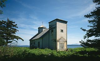
Ouzinkie, is a hamlet on Spruce Island in Kodiak Island Borough, Alaska, United States. At the 2010 census the population was 161, down from 225 in 2000.

Port Lions is a city located on Kodiak Island in the Kodiak Island Borough of the U.S. state of Alaska. As of the 2010 census, the population of the city was 194, down from 256 in 2000.

Afognak is an island in the Kodiak Archipelago 5 km (3.1 mi) north of Kodiak Island in the U.S. state of Alaska. It is 43 miles (69 km) long from east to west and 23 miles (37 km) wide from north to south and has a land area of 1,812.58 km2 (699.84 sq mi), making it the 18th largest island in the United States. The coast is split by many long, narrow bays. The highest point is 2,546 feet (776 m).

Shelikof Strait is a strait on the southwestern coast of the U.S. state of Alaska between the Alaska mainland to the west and Kodiak and Afognak islands to the east.
The Kodiak Archipelago is an archipelago south of the main land-mass of the state of Alaska, about 405 km (252 mi) by air south-west of Anchorage in the Gulf of Alaska. The largest island in the archipelago is Kodiak Island, the second-largest island in the United States. The archipelago has a length of about 285 km (177 mi) and a width of about 108 km (67 mi), from the Barren Islands on the north to Chirikof Island and the Semidi Islands group on the south. The archipelago contains 13,890 km2 (5,360 sq mi) of land. The Kodiak Archipelago contains about 40 small glaciers, numerous streams and many species of land and marine animals. Much of its land is forested.
Afognak (; also Agw'aneq in Alutiiq was an Alutiiq village on the island of Afognak in Kodiak Island Borough, Alaska, United States. It was located on Afognak Bay on the southwest coast of the island, three miles north of Kodiak Island. The site is now within the CDP of Aleneva.
Sitkalidak Island is an island in the western Gulf of Alaska in the Kodiak Island Borough of the state of Alaska, United States. It lies just off the southeast shore of Kodiak Island, across the Sitkalidak Strait from the city of Old Harbor. The island has a land area of 300 square kilometers (120 sq mi) and no resident population.
Near Island is an island that comprises part of the city of Kodiak, Alaska, United States. It lies across the Near Island Channel just south of downtown Kodiak. The island is the site of St. Herman Harbor, the newer of Kodiak's two marinas. Near island has a land area of 1.117 km2 and a resident population of six people as of the 2000 census. It is connected to downtown Kodiak by the Near Island Bridge on Dog Bay Road.
The Semidi Islands are a group of islands of the state of Alaska, United States, lying offshore in the Gulf of Alaska. The islands are part of Kodiak Island Borough and are located southwest of Kodiak Island, about halfway between the Alaska Peninsula mainland and Chirikof Island. The largest islands of the group are Aghiyuk Island and Chowiet Island. The island group has a total land area of 30.178 km2 and is uninhabited. They are part of the Alaska Peninsula unit of the Alaska Maritime National Wildlife Refuge.
Marmot Island is an island of the Kodiak Archipelago in the Gulf of Alaska in the U.S. state of Alaska. It is part of Kodiak Island Borough and lies east of Afognak Island. The island has a land area of 45.196 km2 and is unpopulated.

Raspberry Island is an island of the Kodiak Archipelago located in the Gulf of Alaska in the U.S. state of Alaska. It is located two miles northwest of Whale Island, and just across the mile-wide Raspberry Strait from the southwestern end of Afognak. The island is separated from Kodiak Island by the Kupreanof Strait, with the Shelikof Strait to the northwest. Raspberry Island is 18 miles (29 km) long with a width that varies from 3 miles (4.8 km) to 8 miles (12.9 km). The highest point on the island is 3,300 ft.

Shuyak Island is an island in the northern part of the Kodiak Archipelago in the state of Alaska, United States. It is located just north of Afognak Island, separated from it by the narrow Shuyak Strait. The Stevenson Entrance to Cook Inlet separates it from the Barren Islands farther north in the archipelago. The island has an area of 168.3 km2 and reported an official population of four persons at the 2000 census. Alaska's Shuyak Island State Park comprises most of the island's territory. The island's current major industry is tourism based on camping, recreational fishing, hunting, and kayaking. In the past the island was home to a large fish processing plant at Port William, but that industry has since declined with the advent of factory ships.
Afognak Island State Park is a 75,047-acre (30,370 ha) Alaska state park on Afognak Island in Kodiak Island Borough, Alaska in the United States. Afognak Island is northeast of Kodiak Island on the Alaska Peninsula. Most of Afognak Island State Park is undeveloped. The park is known for its rugged topography and wide variety of wildlife. Afognak Island State Park is open to year-round recreation, including fishing, hunting, and hiking. Transportation is provided by float plane from Kodiak to various areas around the park. It is on the northern and eastern ends of the island and surrounds Perenosa, Seal and Tonki Bays. It borders part of Kodiak National Wildlife Refuge to the west.
The Barren Islands (Sugpiaq: Usu'unaat) are an archipelago in Alaska in the United States. They are the northernmost islands of the Kodiak Archipelago. The largest island of the group is Ushagat Island. The islands have a combined land area of 16.23 square miles (42.0 km2) and are uninhabited. The largest breeding grounds of seabirds in Alaska are located in the Barren Islands on East Amatuli Island and Nord Island. The archipelago is part of the Alaska Maritime National Wildlife Refuge.
References
- ↑ Whale Island: Block 2011, Census Tract 1, Kodiak Island Borough, Alaska United States Census Bureau
Municipalities and communities of Kodiak Island Borough, Alaska, United States | ||
|---|---|---|
| Cities |  | |
| CDPs | ||
| Ghost towns | ||
57°57′09″N152°47′31″W / 57.95250°N 152.79194°W
| | This article about a location in the Kodiak Island Borough, Alaska is a stub. You can help Wikipedia by expanding it. |