
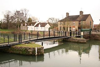
Whinhill Lock was built as part of the Driffield Navigation in the East Riding of Yorkshire, England. It was originally opened in 1770, and was restored in 2004.
Whinhill Lock was built as part of the Driffield Navigation in the East Riding of Yorkshire, England. It was originally opened in 1770, and was restored in 2004.
Located between the village of Wansford and town of Driffield, the lock is easily accessible from the B1249 road.
The lock was built during the construction of the Driffield Navigation between 1767 and 1770, and is a grade II listed structure. [1] [2] After the last traffic to Driffield stopped around 1945 the lock gradually fell into disrepair. In 1968 the Driffield Navigation Amenities Association started to restore and maintain the canal and its structures. [3] Various "working parties" have been held at the lock over the years, to conserve the structure, but in 2004 a lottery grant was secured to restore and re-gate it.
The lock was reopened by the Mayor of Driffield Mrs Margaret Killin on 25 June 2005. [4]

The River Gipping is the source river for the River Orwell in the county of Suffolk in East Anglia, England, which is named from the village of Gipping, and which gave its name to the former Gipping Rural District. The name is unrelated to the name of Ipswich. although the County Town takes its name from Gippeswic. It rises near Mendlesham Green and flows in a south-westerly direction to reach Stowmarket. From there it flows towards the south or south east, passing through Needham Market and a number of villages to reach Ipswich, where it becomes the Orwell. The river has supplied power to a number of watermills, several of which are still standing. None is operational, although the mill at Baylham retains most of its machinery, and is the only complete mill on the river.

The Thames and Severn Canal is a canal in Gloucestershire in the south of England, which was completed in 1789. It was conceived as part of a canal route from Bristol to London. At its eastern end, it connects to the River Thames at Inglesham Lock near Lechlade, while at its western end, it connects to the Stroudwater Navigation at Wallbridge near Stroud, and thence to the River Severn. It has one short arm (branch), from Siddington to the town of Cirencester. It includes Sapperton Tunnel, which when built was the longest canal tunnel in Britain, and remains the second longest complete tunnel. There were always problems with water supply, as no reservoirs were built, while the summit section near the tunnel ran through porous limestone, and there were constant difficulties with leakage. Competition from the railways took much of the canal's traffic by the end of the 19th century, and most of the canal was abandoned in 1927, the remainder in 1941.
The River Hull is a navigable river in the East Riding of Yorkshire in Northern England. It rises from a series of springs to the west of Driffield, and enters the Humber Estuary at Kingston upon Hull. Following a period when the Archbishops of York charged tolls for its use, it became a free navigation. The upper reaches became part of the Driffield Navigation from 1770, after which they were again subject to tolls, and the section within the city of Hull came under the jurisdiction of the Port of Hull, with the same result.
The Hertford Union Canal or Duckett's Cut is just over 1 mile (1.6 km) long in the London Borough of Tower Hamlets in East London. It connects the Regent's Canal to the Lee Navigation. It was opened in 1830 but quickly proved to be a commercial failure. It was acquired by the Regents Canal Company in 1857, and became part of the Grand Union Canal in 1927.

The River Rother flows from Empshott in Hampshire, England, to Stopham in West Sussex, where it joins the River Arun. At 52 kilometres (32 mi) long, most of the river lies within West Sussex except for the first 10 kilometres (6.2 mi) which lie in Hampshire. The upper river, from its source to Midhurst, has been used to power watermills, with the earliest recorded use being in 1086, when the Domesday survey was conducted. Although none is still operational, many of the buildings which housed the mills still exist, and in some cases, still retain their milling machinery. This upper section is also noted for a number of early bridges, which have survived since their construction in the fifteenth, sixteenth and seventeenth centuries.

The Huddersfield Broad Canal or Sir John Ramsden's Canal, is a wide-locked navigable canal in West Yorkshire in northern England. The waterway is 3.75 miles (6 km) long and has 9 wide locks. It follows the valley of the River Colne and connects the Calder and Hebble Navigation at Cooper Bridge junction with the Huddersfield Narrow Canal near Aspley Basin in Huddersfield.

The National Waterways Museum (NWM) is in Ellesmere Port, Cheshire, England, at the northern end of the Shropshire Union Canal where it meets the Manchester Ship Canal. The museum's collections and archives focus on the Britain's navigable inland waterways, including its rivers and canals, and include canal boats, traditional clothing, painted canal decorative ware and tools. It is one of several museums and attractions operated by the Canal & River Trust, the successor to The Waterways Trust.

The Leven Canal runs for 3.18 miles (5.1 km) from the River Hull to the village of Leven, East Riding of Yorkshire, England. It was built for Mrs Charlotta Bethell in 1805, and remained in use until 1935. It is now a Site of Special Scientific Interest.

The Louth Navigation was a canalisation of the River Lud. It ran for 11 miles (18 km) from Louth in Lincolnshire, England, to Tetney Haven, at the mouth of the Humber. It was authorised by Act of Parliament in 1763 and completed in 1770, under the supervision of the engineer John Grundy Jr. and then by James Hogard. Eight locks were required to overcome the difference in altitude, six of which were constructed with sides consisting of four elliptical bays, a design only ever used on this canal in Britain.

The Driffield Navigation is an 11-mile (18 km) waterway, through the heart of the Holderness Plain to the market town of Driffield, East Riding of Yorkshire, England. The northern section of it is a canal, and the southern section is part of the River Hull. Construction was authorised in 1767, and it was fully open in 1770. Early use of the navigation was hampered by a small bridge at Hull Bridge, which was maintained by Beverley Corporation. After protracted negotiation, it was finally replaced in 1804, and a new lock was built to improve water levels at the same time. One curious feature of the new works were that they were managed quite separately for many years, with the original navigation called the Old Navigation, and the new works called the New Navigation. They were not fully amalgamated until 1888.

The Hull–Scarborough line, also known as the Yorkshire Coast Line, is a minor railway line in northern England used primarily for passenger traffic. It runs northwards from Hull Paragon via Beverley and Driffield to Bridlington, joining the York–Scarborough line at a junction near Seamer before terminating at Scarborough railway station.

Bethells Bridge, a swing bridge on the Driffield Navigation in the East Riding of Yorkshire, England. The bridge was built to access land cut off after a new section of canal was made. It is now home to many boat moorings, and popular with fishermen.

Struncheon Hill Lock was built as a later addition to the Driffield Navigation in the East Riding of Yorkshire, England. It improved access to the next section of water during low tide conditions, and is the first lock. It is sometimes known as "Top Hill Low", which is the name of the large pumping station located there.

West Beck is the common name given to the upper section of the old River Hull, as it rises in the foothills of the Yorkshire Wolds. After reaching Frodingham Beck at Emmotland, it becomes called the River Hull. It is noteworthy for being the most northerly chalk stream in England. It provides fly fishing for wild brown trout and grayling.

Snakeholme Lock is a brick chamber canal lock on the Driffield Navigation, in the East Riding of Yorkshire, England. It is notable in being a staircase lock, but only the upper lock is still used. It was designated Grade II in 1986.
Stamford Canal, now disused, is one of the earliest post-Roman canals in England. It opened in 1670, around 100 years before the start of the Industrial Revolution which brought about the "golden age" for canals in Britain. Parts of the route can be traced on the ground, though only one lock survives intact. It was part of the Welland Navigation in Lincolnshire. First authorised in 1571, during the reign of Elizabeth I, construction did not start until 1664, under powers granted in 1620 and ratified by James I. It ran for 9.5 miles (15.3 km) from Stamford to Market Deeping and had 12 locks, two of which were on the river section at Deeping St James. No plans of its construction survive, although one of the locks was documented by a visiting water engineer in 1699. It contributed to the wealth of Stamford, allowing barley to be transported to the town for malting.

Wansford is a village in the East Riding of Yorkshire, England; it forms part of the civil parish of Skerne and Wansford. It is situated on the B1249 road and just to the north of the River Hull and the Driffield Canal. It is approximately 2.5 miles (4 km) south-east of Driffield and 3 miles (4.8 km) north-west of North Frodingham.
Kings Norton Junction is the name of the canal junction where the Stratford-upon-Avon Canal terminates and meets the Worcester and Birmingham Canal at Kings Norton, Birmingham, England.

The Sleaford Navigation was a 12.5 mile (20.1 km) canalisation of the River Slea in Lincolnshire, England, which opened in 1794. It ran from a junction with the River Witham, near Chapel Hill to the town of Sleaford through seven locks, most of which were adjacent to mills. Lack of finance meant that it stopped short of its intended terminus, but it gradually grew to be successful financially. The coming of the railways in 1857 led to a rapid decline, and it was officially abandoned by an act of Parliament in 1878, but remained open for a further three years. The lower part of it remained navigable until the 1940s, when it was blocked by a sluice.

Wansford Lock was built as part of the Driffield Navigation in the East Riding of Yorkshire, England. It was opened in 1770, and restored in 2009. It was designated Grade II in 1985.
| Wikimedia Commons has media related to Whinhill Lock . |