Whinlatter Pass

Last updated

The summit of the Whinlatter Pass and the entrance to the Whinlatter Forest Park. Whinlatter Forest Park Sign.jpg
The summit of the Whinlatter Pass and the entrance to the Whinlatter Forest Park.

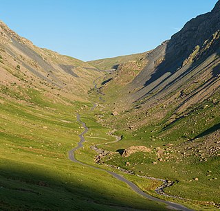
The Whinlatter Pass is a mountain pass in the English Lake District. It is located on the B5292 road linking Braithwaite, to the west of Keswick, with High Lorton to the south of Cockermouth. [1]

Mountain pass Route through a mountain range or over a ridge

A mountain pass is a navigable route through a mountain range or over a ridge. Since many of the world's mountain ranges have presented formidable barriers to travel, passes have played a key role in trade, war, and both human and animal migration throughout Earth's history. At lower elevations it may be called a hill pass. The highest vehicle-accessible pass in the world appears to be Mana Pass, located in the Himalayas on the border between India and Tibet, China.

England Country in north-west Europe, part of the United Kingdom

England is a country that is part of the United Kingdom. It shares land borders with Wales to the west and Scotland to the north-northwest. The Irish Sea lies west of England and the Celtic Sea lies to the southwest. England is separated from continental Europe by the North Sea to the east and the English Channel to the south. The country covers five-eighths of the island of Great Britain, which lies in the North Atlantic, and includes over 100 smaller islands, such as the Isles of Scilly and the Isle of Wight.

Lake District mountainous region in North West England

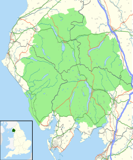
The Lake District, also known as the Lakes or Lakeland, is a mountainous region in North West England. A popular holiday destination, it is famous for its lakes, forests and mountains, and its associations with William Wordsworth and other Lake Poets and also with Beatrix Potter and John Ruskin. The National Park was established in 1951 and covers an area of 2,362 square kilometres. It was designated a UNESCO World Heritage Site in 2017.

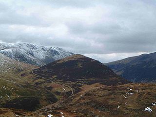
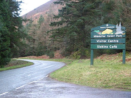
To the north the pass is flanked by Whinlatter fell, while to the south the Whiteside, Hopegill Head and Grisedale Pike fells borders the pass. From the top of the pass, paths climb Whinlatter and Grisedale Pike. There is also a Forestry Commission tourist centre there.

Whinlatter mountain in United Kingdom

Whinlatter is a small fell in the north west of the English Lake District, just north of the Whinlatter Pass. It is easily climbed from the top of the Whinlatter Pass, through the Forestry Commission plantations. The Whinlatter Visitor's Centre, a popular tourist attraction, is on the south side of the fell. The hill is part of a horseshoe around the valley of Aiken Beck. The fell's name originates from a combination of the Old Norse and Gaelic languages. With the Old Norse word 'hvin' meaning gorse or furze, and the Gaelic word 'lettir' meaning slope, the name translates as "The Gorse or furze-covered slope.".

Whiteside (Lake District) mountain in United Kingdom

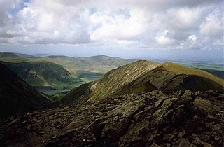
Whiteside is a fell in the north-western area of the English Lake District. It stands at the western end of the Grisedale Pike- Hopegill Head ridge overlooking Crummock Water.

Hopegill Head mountain in United Kingdom

Hopegill Head is a fell in the English Lake District in Cumbria. It is located nine kilometres west of the town of Keswick and is well seen from the B5292 road which crosses the Whinlatter Pass.

The Whinlatter Pass is one of three passes that link the tourist area around Keswick, including Derwent Water and Borrowdale, with the valley of the River Cocker, including the lakes of Buttermere, Crummock Water and Loweswater. From north to south these passes are the Whinlatter Pass, the Newlands Pass, and the Honister Pass. The Whinlatter Pass can be icy in winter, but it is a less severe route than the other two passes. [1]

Borrowdale civil parish in England

Borrowdale is a valley and civil parish in the English Lake District in the Borough of Allerdale in Cumbria, England. It lies within the historic county boundaries of Cumberland. It is sometimes referred to as Cumberland Borrowdale to distinguish it from another Borrowdale in the historic county of Westmorland.

River Cocker, Cumbria river in Cumbria, United Kingdom

The River Cocker is a river in the Lake District in North West England, in the county of Cumbria. Its source is at the head of the Buttermere valley. It flows north through Buttermere and then Crummock Water, through Lorton Vale, to the town of Cockermouth, where it joins the River Derwent. It is roughly 12 miles (19 km) long. The river takes its name from the Brythonic Celtic word kukrā, meaning 'the crooked one.'

Buttermere lake in the United Kingdom

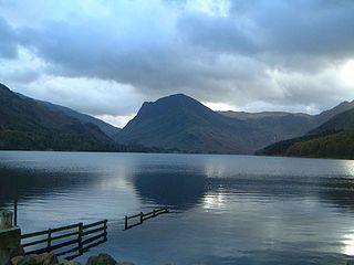
Buttermere is a lake in the English Lake District in North West England. The adjacent village of Buttermere takes its name from the lake. Historically in Cumberland, the lake is now within the county of Cumbria. It is owned by the National Trust, forming part of its Buttermere and Ennerdale property.

The Pass was used for the first King of the Mountains climb on the second stage of the 2016 Tour of Britain cycle race. [2]

2016 Tour of Britain

The 2016 Tour of Britain was a nine-stage men's professional road cycling race. It was the thirteenth running of the modern version of the Tour of Britain and the 76th British tour in total. The race started on 4 September in Glasgow and finished on 11 September in London. The race was part of the 2016 UCI Europe Tour.

See also

Related Research Articles

Scafell Pike highest mountain in England

Scafell Pike or is the highest mountain in England, at an elevation of 978 metres (3,209 ft) above sea level. It is located in the Lake District National Park, in Cumbria, and is part of the Southern Fells.

Helvellyn mountain in the English Lake District

Helvellyn is a mountain in the English Lake District, the highest point of the Helvellyn range, a north-south line of mountains to the north of Ambleside, between the lakes of Thirlmere and Ullswater.

Skiddaw mountain in the United Kingdom

Skiddaw is a mountain in the Lake District National Park in England. Its 931-metre (3,054 ft) summit is the sixth-highest in England. It lies just north of the town of Keswick, Cumbria, and dominates the skyline in this part of the northern lakes. It is the simplest of the Lake District mountains of this height to ascend and, as such, many walking guides recommend it to the occasional walker wishing to climb a mountain. This is the first summit of the fell running challenge known as the Bob Graham Round when undertaken in a clockwise direction.

Wasdale is a valley and civil parish in the western part of the Lake District National Park in Cumbria, England. The River Irt flows through the valley to its estuary at Ravenglass. A large part of the main valley floor is occupied by Wastwater, the deepest lake in England (258 feet). The population of Wasdale was only minimal and, from the 2011 Census is included in the parish of Gosforth.

Honister Pass mountain pass

Honister Pass is a mountain pass in the English Lake District. It is located on the B5289 road, linking Seatoller, in the valley of Borrowdale, to Gatesgarth at the southern end of Buttermere. The pass reaches an altitude of 1,167 feet (356 m), making it one of the highest in the region, and also one of the steepest, with gradients of up to 1-in-4 (25%). The saddle at the watershed is known as Honister Hause, using the Cumbrian word hause for such a feature.

Causey Pike mountain in United Kingdom

Causey Pike is a fell in the English Lake District. It is situated in the Newlands Valley, 5 km south-west of the town of Keswick. Even though it has a modest height of 637 metres (2,090 ft) it is one of the most distinctive fells when viewed from the Derwent Water and Keswick area due to its distinguishing summit "knobble" which catches the eye. The fell is one of 214 fells described by Alfred Wainwright in his series of Pictorial Guides to the Lakeland Fells: Causey Pike features in Book Six, The North Western Fells.

Furness Fells hills and mountains in the Furness region of Cumbria, England

The Furness Fells are a multitude of hills and mountains in the Furness region of Cumbria, England. Historically part of Lancashire, the Furness Fells or High Furness is the name given to the upland part of Furness, that is, that part of Furness lying north of the line between Ulverston and Ireleth. The hills lie largely within the English Lake District.

Grisedale Pike mountain in United Kingdom

Grisedale Pike is a fell in the Lake District, Cumbria, England situated 4.5 miles (7.2 km) west of the town of Keswick in the north-western sector of the national park. At a height of 791 m (2593 feet) it is the 40th-highest Wainwright in the Lake District; it also qualifies as a Hewitt, Marilyn and Nuttall. Grisedale Pike presents a striking appearance when viewed from the east, particularly from the vicinity of Keswick. It possesses two subsidiary summits: one unnamed ; the other Hobcarton End.

Outerside mountain in United Kingdom

Outerside is a fell in the Lake District in Cumbria, England. It is located 6 kilometres west of Keswick in the north western part of the national park and is a smaller member of the Coledale group of fells with a height of 568 metres (1863 feet). The fell is part of a ridge on the southern side of Coledale which descends from the higher fell of Scar Crags and continues over the neighbouring smaller fell of Barrow before reaching the valley at the village of Braithwaite.

Scar Crags mountain in United Kingdom

Scar Crags is a fell in the north western part of the English Lake District in the county of Cumbria. It is one of the Coledale group of fells situated seven kilometres south west of Keswick and reaches a height of 672 metres (2205 feet).

Eastern Fells

The Eastern Fells are a group of hills in the English Lake District. Centred on Helvellyn they primarily comprise a north–south ridge running between Ullswater and Lakeland's Central Valley.

North Western Fells

The North Western Fells are a group of hills in the English Lake District. Including such favourites as Catbells and Grisedale Pike, they occupy an oval area beneath the Buttermere and Borrowdale valley systems. The North Western Fells are characterised by soaring east-west ridges and an absence of mountain tarns.

Seathwaite, Allerdale human settlement in United Kingdom

Seathwaite is a small hamlet in Borrowdale valley in the Lake District of Cumbria, North West England. It is located 13 kilometres (8 mi) southwest of Keswick at the end of a minor road that heads southwest from the hamlet of Seatoller, which is where the B5289 road begins its steep climb up the pass to Honister Hause on the boundary between Borrowdale civil parish and Buttermere civil parish.

Chapel Beck is a minor river in the county of Cumbria in England.

Newlands Pass

The Newlands Pass, also known as Newlands Hause, is a mountain pass in the English Lake District. It is located on an unclassified road linking the Newlands Valley, to the west of Keswick and Derwent Water, with the village of Buttermere. The highest point on the pass is at an altitude of 1,093 feet (333 m).

Braithwaite village in United Kingdom

Braithwaite is a village in the northern Lake District, in Cumbria, England. Historically in Cumberland, it lies just to the west of Keswick and to the east of the Grisedale Pike ridge, in the Borough of Allerdale. It forms part of the civil parish of Above Derwent.

References

  1. 1 2 "Whinlatter Pass". Visit Cumbria. Retrieved 2010-01-13.
  2. "Tour of Britain - plan ahead when travelling in Cumbria on Monday 5 September". Cumbria County Council . 30 August 2016. Retrieved 16 October 2016.

Coordinates: 54°36′35″N3°14′54″W / 54.6096°N 3.2483°W / 54.6096; -3.2483

Geographic coordinate system Coordinate system

A geographic coordinate system is a coordinate system that enables every location on Earth to be specified by a set of numbers, letters or symbols. The coordinates are often chosen such that one of the numbers represents a vertical position and two or three of the numbers represent a horizontal position; alternatively, a geographic position may be expressed in a combined three-dimensional Cartesian vector. A common choice of coordinates is latitude, longitude and elevation. To specify a location on a plane requires a map projection.