
The Continental Divide of the Americas is the principal, and largely mountainous, hydrological divide of the Americas. The Continental Divide extends from the Bering Strait to the Strait of Magellan, and separates the watersheds that drain into the Pacific Ocean from those river systems that drain into the Atlantic and Arctic Ocean, including those that drain into the Gulf of Mexico, the Caribbean Sea, and Hudson Bay.

Mount Waddington, once known as Mystery Mountain, is the highest peak in the Coast Mountains of British Columbia, Canada. Although it is lower than Mount Fairweather and Mount Quincy Adams, which straddle the United States border between Alaska and British Columbia, Mount Waddington is the highest peak that lies entirely within British Columbia. It and the subrange which surround it, known as the Waddington Range, stand at the heart of the Pacific Ranges, a remote and extremely rugged set of mountains and river valleys.

A jökulhlaup is a type of glacial outburst flood. It is an Icelandic term that has been adopted in glaciological terminology in many languages. It originally referred to the well-known subglacial outburst floods from Vatnajökull, Iceland, which are triggered by geothermal heating and occasionally by a volcanic subglacial eruption, but it is now used to describe any large and abrupt release of water from a subglacial or proglacial lake/reservoir.

Glacier National Park is part of a system of 43 parks and park reserves across Canada, and one of seven national parks in British Columbia. Established in 1886, the park encompasses 1,349 km2 (521 sq mi), and includes a portion of the Selkirk Mountains which are part of the larger grouping of mountains, the Columbia Mountains. It also contains the Rogers Pass National Historic Site.

Garibaldi Provincial Park, also called Garibaldi Park, is a wilderness park located on the coastal mainland of British Columbia, Canada, 70 kilometres (43.5 mi) north of Vancouver. It was established in 1920 and named a Class A Provincial Park of British Columbia in 1927. The park is a popular destination for outdoor recreation, with over 30,000 overnight campers and over 106,000 day users in the 2017/2018 season.

Kokanee is a beer brewed at the Columbia Brewery in Creston, British Columbia. Columbia Brewery began brewing Kokanee lager in 1959 and was purchased by the Labatt Brewing Company in 1974.

The Black Tusk, known as Q̓elqámtensa ti Skenknápa in the St'at'imcets (Lillooet) language and as T'ákt'akmúten tl'a Ín7inyáx̱a7en in the Sḵwx̱wú7mesh (Squamish) language, is a stratovolcano and a pinnacle of volcanic rock in Garibaldi Provincial Park of British Columbia, Canada. At 2,319 m (7,608 ft) above sea level, the upper spire is visible from a great distance in all directions. It is particularly noticeable from the Sea-to-Sky Highway just south of Whistler, British Columbia. Distinctive and immediately identifiable, The Black Tusk is among the best known mountains in the Garibaldi Ranges of the Coast Mountains. The volcano is part of the Garibaldi Volcanic Belt which is a segment of the Canadian Cascade Arc, but it is not within the geographic boundary of the Cascade Range.

Brandywine Falls Provincial Park is a provincial park in British Columbia, Canada, located adjacent to BC Highway 99 between Garibaldi and Whistler, British Columbia. It is managed by Sea to Sky Parks for BC Parks.

The retreat of glaciers since 1850 is well documented and is one of the effects of climate change. The retreat of mountain glaciers provide evidence for the rise in global temperatures since the late 19th century. Examples include mountain glaciers in western North America, Asia, the Alps in central Europe and tropical and subtropical regions of South America and Africa. Since glacial mass is affected by long-term climatic changes, e.g., precipitation, mean temperature, and cloud cover, glacial mass changes are one of the most sensitive indicators of climate change. Retreat of glaciers is also a major reason for sea level rise. Excluding peripheral glaciers of ice sheets, the total cumulated global glacial losses over the 26-year period from 1993 to 2018 were likely 5500 gigatons, or 210 gigatons per yr.

Hoodoo Mountain, sometimes referred to as Hoodoo Volcano, is a potentially active stratovolcano in the Northern Interior of British Columbia, Canada. It is located 25 kilometres northeast of the Alaska–British Columbia border on the north side of the Iskut River opposite of the mouth of the Craig River. With a summit elevation of 1,850 metres and a topographic prominence of 900 metres, Hoodoo Mountain is one of many prominent peaks within the Boundary Ranges of the Coast Mountains. Its flat-topped summit is covered by an ice cap more than 100 metres thick and at least 3 kilometres in diameter. Two valley glaciers surrounding the northwestern and northeastern sides of the mountain have retreated significantly over the last hundred years. They both originate from a large icefield to the north and are the sources of two meltwater streams. These streams flow along the western and eastern sides of the volcano before draining into the Iskut River.

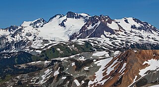
The Mount Meager massif is a group of volcanic peaks in the Pacific Ranges of the Coast Mountains in southwestern British Columbia, Canada. Part of the Cascade Volcanic Arc of western North America, it is located 150 km (93 mi) north of Vancouver at the northern end of the Pemberton Valley and reaches a maximum elevation of 2,680 m (8,790 ft). The massif is capped by several eroded volcanic edifices, including lava domes, volcanic plugs and overlapping piles of lava flows; these form at least six major summits including Mount Meager which is the second highest of the massif.

Mount Price is a small stratovolcano in the Garibaldi Ranges of the Pacific Ranges in southwestern British Columbia, Canada. It has an elevation of 2,049 metres and rises above the surrounding landscape on the western side of Garibaldi Lake in New Westminster Land District. The mountain contains a number of subfeatures, including Clinker Peak on its western flank, which was the source of two thick lava flows between 15,000 and 8,000 years ago that ponded against glacial ice. These lava flows are structurally unstable, having produced large landslides as recently as the 1850s. A large provincial park surrounds Mount Price and other volcanoes in its vicinity. It lies within an ecological region that surrounds much of the Pacific Ranges.

Glacier morphology, or the form a glacier takes, is influenced by temperature, precipitation, topography, and other factors. The goal of glacial morphology is to gain a better understanding of glaciated landscapes and the way they are shaped. Types of glaciers can range from massive ice sheets, such as the Greenland ice sheet, to small cirque glaciers found perched on mountain tops. Glaciers can be grouped into two main categories:
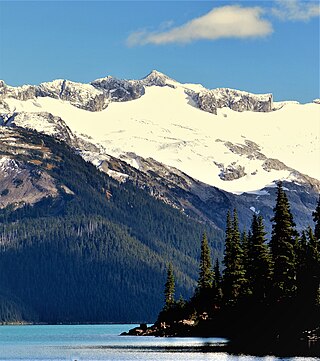
Garibaldi Lake is a turquoise-coloured alpine lake in British Columbia, Canada, located 37 km (23 mi) north of Squamish and 19 km (12 mi) south of Whistler. The lake lies within Garibaldi Provincial Park, which features mountains, glaciers, trails, forests, flowers, meadows, waterfalls. The park is a wildlife protected area.

Blackcomb Peak is a mountain located east of Whistler, British Columbia that forms the boundary between the Whistler Blackcomb ski resort and Garibaldi Provincial Park. Like Whistler Mountain, it is located on the edge of Garibaldi Provincial Park and the ski lifts are often used to access the park, particularly for the Spearhead Traverse.

Fitzsimmons Creek is a large creek in Whistler, British Columbia, Canada, having its origins at the Fitzsimmons Glacier in the Garibaldi Ranges of the Coast Mountains. For half its length of approximately 10 kilometres, the creek courses a U-shaped glacial valley which separates two ski mountains of the Whistler Blackcomb resort, Blackcomb to the north and Whistler to the south.
Overlord Mountain is a 2,625-metre (8,612-foot) glacier-clad peak located in the Garibaldi Ranges of the Coast Mountains, in Garibaldi Provincial Park of southwestern British Columbia, Canada. It is the highest point of the Fitzsimmons Range, which is a subset of the Garibaldi Ranges, and can be readily seen from the Whistler Blackcomb ski area. It is situated 15 km (9 mi) southeast of Whistler, and its nearest higher peak is Mount Macbeth, 3 km (2 mi) to the north-northeast. The Benvolio Glacier rests below the south aspect of the summit, the Fitzsimmons Glacier on the east aspect, and the expansive Overlord Glacier spans the northern and western aspects of the mountain. Precipitation runoff from the peak and meltwater from its glaciers drains into tributaries of the Cheakamus River. The first ascent of the mountain was made in 1923 by Phyllis Munday and Don Munday via the Benvolio Glacier. The mountain's descriptive name was recommended by the Garibaldi Park Board and officially adopted on September 2, 1930, by the Geographical Names Board of Canada.

Mount Fitzsimmons is a 2,603-metre (8,540-foot) glacier-clad peak located in the Garibaldi Ranges of the Coast Mountains, in Garibaldi Provincial Park of southwestern British Columbia, Canada. It is the third-highest point of the Fitzsimmons Range, which is a subset of the Garibaldi Ranges. It is situated 15 km (9 mi) southeast of Whistler, and its nearest higher peak is Mount Benvolio, 0.5 km (0 mi) to the west-southwest. The Diavolo Glacier spreads out below the southeast aspect of the summit, and the Fitzsimmons Glacier descends the northwest slopes. Precipitation runoff from the peak and meltwater from its glaciers drains into tributaries of the Cheakamus River. The first ascent of the mountain was made on August 19, 1924, by a party of the British Columbia Mountaineering Club. The peak was named for prospector James Fitzsimmons, who built a trail along Fitzsimmons Creek in an effort to haul supplies to a small copper mine he staked and worked. The mountain's name was officially adopted on September 2, 1930, by the Geographical Names Board of Canada.
Mount Carr is a 2,590-metre (8,497-foot) mountain summit located in British Columbia, Canada.

Ipsoot Mountain is a 2,576-metre (8,451-foot) glaciated summit located in southwest British Columbia, Canada.