Whitby Township

Last updated

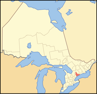
Whitby Township is a geographic township and former municipality in what was Ontario County (now Durham Region), Ontario, Canada. It is now part of the Town of Whitby.

Ontario County was the name of two historic counties in the Canadian province of Ontario.

Canada Country in North America

Canada is a country in the northern part of North America. Its ten provinces and three territories extend from the Atlantic to the Pacific and northward into the Arctic Ocean, covering 9.98 million square kilometres, making it the world's second-largest country by total area. Canada's southern border with the United States, stretching some 8,891 kilometres (5,525 mi), is the world's longest bi-national land border. Its capital is Ottawa, and its three largest metropolitan areas are Toronto, Montreal, and Vancouver. As a whole, Canada is sparsely populated, the majority of its land area being dominated by forest and tundra. Consequently, its population is highly urbanized, with over 80 percent of its inhabitants concentrated in large and medium-sized cities, with 70% of citizens residing within 100 kilometres (62 mi) of the southern border. Canada's climate varies widely across its vast area, ranging from arctic weather in the north, to hot summers in the southern regions, with four distinct seasons.

Whitby, Ontario Town in Ontario, Canada

Whitby is a town in Durham Region. Whitby is located in Southern Ontario east of Ajax and west of Oshawa, on the north shore of Lake Ontario, and is home to the headquarters of Durham Region. It had a population of 128,377 at the 2016 census and it is approximately 20 km (12 mi) east of the Toronto borough of Scarborough, and it is known as a commuter suburb in the eastern part of the Greater Toronto Area. While the southern portion of Whitby is predominantly urban and an economic hub, the northern part of the municipality is more rural and includes the communities of Ashburn, Brooklin, Myrtle, and Myrtle Station.

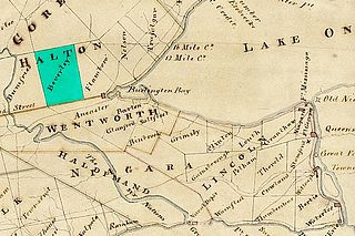
The Township was established in 1792 as part of what was then York County. Whitby Township was one of five townships along Lake Ontario named for towns in northeast England (York, Scarborough, Pickering, Whitby and Darlington). In 1852, the Township became part of the newly formed County of Ontario. In 1855, the Town of Whitby was incorporated as a separate municipality in the southern portion of the Township and in 1858, the Township of East Whitby was formed from the eastern portion of the municipality near Oshawa.

York County, Ontario Dissolved County in Ontario, Canada

York County is a historic county in Upper Canada, Canada West, and the Canadian province of Ontario. It was organized by the Upper Canada administration from the lands of the Toronto Purchase and others.

England Country in north-west Europe, part of the United Kingdom

England is a country that is part of the United Kingdom. It shares land borders with Wales to the west and Scotland to the north-northwest. The Irish Sea lies west of England and the Celtic Sea lies to the southwest. England is separated from continental Europe by the North Sea to the east and the English Channel to the south. The country covers five-eighths of the island of Great Britain, which lies in the North Atlantic, and includes over 100 smaller islands, such as the Isles of Scilly and the Isle of Wight.

Scarborough, North Yorkshire town in North Yorkshire, England

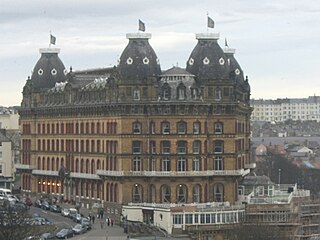
Scarborough is a town on the North Sea coast of North Yorkshire, England. Historically part of the North Riding of Yorkshire, the town lies between 10–230 feet above sea level, rising steeply northward and westward from the harbour on to limestone cliffs. The older part of the town lies around the harbour and is protected by a rocky headland.

Whitby Township was mainly a rural municipality, but contained the communities of Brooklin, Ashburn, Myrtle and Myrtle Station.

Brooklin is a community in the town of Whitby, Ontario, Canada. It is located north of the urban area of Whitby, at the south junction of Ontario Highways 12 and 7.

Ashburn, Ontario Unincorporated community in Ontario, Canada

Ashburn is a hamlet in the town of Whitby, Durham Region, Ontario, Canada, located approximately 15 kilometres north of the town core, and centred on the intersection of Ashburn Road and Myrtle Road. It is a rural settlement area on the Oak Ridges Moraine, situated on the headwaters of the Lynde Creek watershed and part of Ontario's protected Golden Horseshoe Greenbelt.

Myrtle is a community in the Town of Whitby, Durham Region, Ontario, Canada.

The Township was amalgamated with Whitby in 1968 to form an expanded Town of Whitby.

See also

Related Research Articles

Regional Municipality of Durham Regional municipality in Ontario, Canada

The Regional Municipality of Durham, informally referred to as Durham Region, is a regional municipality in Southern Ontario, Canada. Located east of Toronto and the Regional Municipality of York, Durham forms the east-end of the Greater Toronto Area and the core part of the Golden Horseshoe region. It has an area of approximately 2,500 square kilometres. The regional government is headquartered in Whitby.

The Canadian province of Ontario has several historic counties, which are past census divisions that no longer exist today. Most historic counties either merged with other counties, or became regional municipalities or single-tier municipalities. Although counties had existed prior to 1849, after 1849 they replaced the district systems in administering local government and courts in Ontario.

Lennox and Addington County County in Ontario, Canada

Lennox and Addington County is a county and census division of the Canadian province of Ontario. The county seat is Greater Napanee. It is located in the subregion of Southern Ontario named Eastern Ontario.

Lennox County is a historic county in the Canadian province of Ontario which now forms part of Lennox and Addington County. It was named after Charles Lennox, 3rd Duke of Richmond.

Durham County is a historic county in Ontario, Canada. It was named from the English County Durham and city of Durham.

Wentworth County, area 269,057 acres (1,089 km2), is a historic county in the Canadian province of Ontario.

Lincoln County, Ontario Ontario

Lincoln County is a historic county in the Canadian province of Ontario.

Toronto Township is a former municipality that is a geographic township in Mississauga, Ontario, Canada. It is directly to the west of the city of Toronto, and comprises land that makes up the majority of present-day Mississauga.

Durham Region Transit Public transportation agency, located east of Toronto

Durham Region Transit (DRT) is the regional public transit operator in Durham Region, Ontario, Canada, east of Toronto. Its headquarters are at 605 Rossland Rd East in Whitby, Ontario, and there are regional centres in Ajax, Whitby, and Oshawa. It was formed by the merger of Ajax/Pickering Transit, Whitby Transit, Oshawa Transit, and Clarington Transit.

Chinguacousy Township, Ontario human settlement in Ontario, Canada

Chinguacousy Township is a former municipality and geographic township in Peel County, Ontario. In 1973, when Peel County became the Regional Municipality of Peel, it was split in half, with the northern half becoming part of the town of Caledon, and the southern half, along with the township of Toronto Gore, joining the town of Brampton.

Scott, Ontario is a geographic township and former municipality located in what was Ontario County, Ontario, Canada. It is now part of the Township of Uxbridge.

Myrtle Station is a community in the Town of Whitby, Durham Region, Ontario, Canada.

Beverley Township, Ontario

Beverley Township was a township established in 1792 in Home District in the then Upper Canada, today Ontario, Canada. It was named for the town of Beverley in the East Riding of Yorkshire, England, by John Graves Simcoe.

Esquesing Township was a municipality within the historic Halton County in Ontario, Canada. It is today a geographic township in the town of Halton Hills in the Regional Municipality of Halton.

References

The Department of Natural Resources, operating under the FIP applied title Natural Resources Canada (NRCan), is the ministry of the government of Canada responsible for natural resources, energy, minerals and metals, forests, earth sciences, mapping and remote sensing. It was created in 1995 by amalgamating the now-defunct Departments of Energy, Mines and Resources and Forestry. Natural Resources Canada (NRCan) works to ensure the responsible development of Canada's natural resources, including energy, forests, minerals and metals. NRCan also uses its expertise in earth sciences to build and maintain an up-to-date knowledge base of our landmass and resources. To promote internal collaboration, NRCan has implemented a departmental wide wiki based on MediaWiki. Natural Resources Canada also collaborates with American and Mexican government scientists, along with the Commission for Environmental Cooperation, to produce the North American Environmental Atlas, which is used to depict and track environmental issues for a continental perspective.

McGill University English-language university in Montreal, Quebec

McGill University is a public research university in Montreal, Quebec, Canada. It was established in 1821 by royal charter, granted by King George IV. The university bears the name of James McGill, a Montreal merchant originally from Scotland whose bequest in 1813 formed the university's precursor, McGill College.

Coordinates: 43°56′13″N78°55′00″W / 43.93694°N 78.91667°W / 43.93694; -78.91667

Geographic coordinate system Coordinate system

A geographic coordinate system is a coordinate system that enables every location on Earth to be specified by a set of numbers, letters or symbols. The coordinates are often chosen such that one of the numbers represents a vertical position and two or three of the numbers represent a horizontal position; alternatively, a geographic position may be expressed in a combined three-dimensional Cartesian vector. A common choice of coordinates is latitude, longitude and elevation. To specify a location on a plane requires a map projection.