White Breast Creek

Last updated
White Breast Creek
River
Country US
State Iowa
Districts Marion County, Iowa, Clarke County, Iowa, Lucas County, Iowa, Warren County, Iowa
Source
 - coordinates 41°01′45″N93°53′33″W / 41.0292°N 93.8924°W / 41.0292; -93.8924
Mouth Des Moines River
 - elevation 725 ft (221 m)
 - coordinates 41°23′43″N93°02′19″W / 41.3952°N 93.0385°W / 41.3952; -93.0385 Coordinates: 41°23′43″N93°02′19″W / 41.3952°N 93.0385°W / 41.3952; -93.0385
Mouth of White Breast Creek Iowa.gif
Mouth of White Breast Creek (United States Environmental Protection Agency)
U.S. Geological Survey Geographic Names Information System: White Breast Creek

White Breast Creek is an important tributary of the Des Moines River in Iowa. It flows 91.3 miles (146.9 km) [1] from southwest to northeast, rising in Ward Township in Union County, near Osceola, and flowing in an easterly then a northeasterly direction, to its mouth with the Des Moines River at Lake Red Rock.

Des Moines River river in Iowa, United States

The Des Moines River is a tributary of the Mississippi River in the upper Midwestern United States that is approximately 525 miles (845 km) long from its farther headwaters. The largest river flowing across the state of Iowa, it rises in southern Minnesota and flows across Iowa from northwest to southeast, passing from the glaciated plains into the unglaciated hills near the capital city of Des Moines, named after the river, in the center of the state. The river continues to flow at a southeastern direction away from Des Moines, later flowing directly into the Mississippi River.

Iowa State of the United States of America

Iowa is a state in the Midwestern United States, bordered by the Mississippi River to the east and the Missouri River and Big Sioux River to the west. It is bordered by six states; Wisconsin to the northeast, Illinois to the east, Missouri to the south, Nebraska to the west, South Dakota to the northwest and Minnesota to the north.

Union County, Iowa County in the United States

Union County is a county located in the southern part of the U.S. state of Iowa. As of the 2010 census, the population was 12,534. The county seat is Creston. Organized at a time of tensions before the American Civil War, the county was named in 1853 for the Union that people wanted to preserve. The rural county's peak of population was in 1930. Its economy is based on agriculture and related industries. Creston and the county are still served by the Burlington Northern Santa Fe Railroad (BNSF), the largest network in the nation.

Contents

Tributaries

Its first main tributary is South White Breast Creek, on its left bank; this creek has intermittent tributaries named Hoosier Creek and Little Hoosier Creek in Green Bay Township in Clarke County.

Stream bed channel bottom of a stream, river, or creek

A stream bed or streambed is the channel bottom of a stream or river, the physical confine of the normal water flow. The lateral confines or channel margins are known as the stream banks or river banks, during all but flood stage. Under certain conditions a river can branch from one stream bed to multiple stream beds. A flood occurs when a stream overflows its banks and flows onto its flood plain. As a general rule, the bed is the part of the channel up to the normal water line, and the banks are that part above the normal water line. However, because water flow varies, this differentiation is subject to local interpretation. Usually, the bed is kept clear of terrestrial vegetation, whereas the banks are subjected to water flow only during unusual or perhaps infrequent high water stages and therefore might support vegetation some or much of the time.

Clarke County, Iowa County in the United States

Clarke County is a county located in the U.S. state of Iowa. As of the 2010 census, the population was 9,286. The county seat is Osceola. The county was formed in January 1846, one of twelve counties established by legislative action in a comprehensive act. It was named for James Clarke, a Governor of the Iowa Territory.

Brush Creek enters as a right bank tributary south of Lucas, in the Lucas Unit of the Stephens State Forest Wildlife Management Area, in Jackson Township of Lucas County. Indian Creek (White Breast Creek) joins in Liberty Township, also on the left bank.

Lucas, Iowa City in Iowa, USA

Lucas is a city in Lucas County, Iowa, United States. The population was 216 at the 2010 census.

Lucas County, Iowa County in the United States

Lucas County is a county located in the U.S. state of Iowa. As of the 2010 census, the population was 8,898. The county seat is Chariton. The county was formed in 1846 and was named for Robert Lucas, a Governor of the Territory.

Little White Breast Creek enters from the right bank, also in Liberty Township in Lucas County. This creek rises north and east of Chariton from Lake Morris and Lake Ellis, two small reservoirs.

Chariton, Iowa City in Iowa, USA

Chariton is a city in and the county seat of Lucas County, Iowa, United States. The population was 4,321 at the 2010 census. It is the primary distribution center for and the former corporate headquarters of the Hy-Vee supermarket chain.

The next three left bank tributaries are Barker Creek (White Breast Creek), a short stream confined to Liberty Township in Lucas County; Stoney Creek (White Breast Creek) then Cotton Creek (White Breast Creek) join White Breast Creek near Lacona.

Lacona, Iowa City in Iowa, United States

Lacona is a city in Warren County, Iowa, United States. The population was 361 at the 2010 census. It is part of the Des Moines–West Des Moines Metropolitan Statistical Area.

Wolf Creek (White Breast Creek) and its tributary, Flank Creek (White Breast Creek) enter on the left bank in Dallas Township, a few miles west of Dallas. A few miles north of Dallas, the creek has a significant floodplain, regularly subject to inundation.

Melcher-Dallas, Iowa City in Iowa, United States

Melcher-Dallas is a city in Marion County, Iowa, United States. The population was 1,288 at the 2010 census.

Hawk Run (White Breast Creek) is the last significant tributary, entering near Lake Red Rock on the left bank.

You should probably add Wind Branch which enters from the right about 3 1/2 miles south of Lacona. And though it nearly runs dry, it comes out in a hurry with a substantial rain. Takes about 2" in a short time to bring it out (over the flat bridge on paved State Road 69. Wind Branch drains the hills going up to Newburn. Town of few people (today, as opposed to the turn of last century), last I knew it had a ballfield. Believe it died because railroad never came through like surviving communities of Lacona and Milo, both Warren County. Also, doesn't likely have a paved road either.

 The county line dirt road (bordering Warren and Marion Counties, west of Wind Branch creek in Warren before the bridge And east of it on the Marion County side) used to run across the floodplain/bottomlands till hurricane Ivan came up the Mississippi Valley in 2005. It was never rebuilt. The road over White Breast was as it is paved and state road and a major artery to Knoxville.  Of interest, to me at least, are a few other items. One is Bauer. What's left of it sets on the highest hill above the conjunction of Wind Branch and White Breast. Basically a Catholic church, school, and cemetery, a couple houses yet, I think. Not likely ever incorporated, I think. Plus the top of the hills above "the old channel" had Indian burial mounds and likely a large settlement nearby. Apparently still there during the early settlement period of white immigrants. Maybe e historical society will check me out on this.Only know I found a few arrow heads in Wind Branch and that people would search the bottomlands for them and other artifacts after spring plowing.  Back to the "od channel"; it was on our bottom, Marion County side. Before the work during and after the Great Depression, the tortuous path of White Breast where Wind Branch came in was straightened. Though still fills with water every time White Breast comes out. Drains through the field tiles eventually. But not before the fishing in it gets good. As far as the rest of the Marion County/ White Breast/ Wind Branch bottom, ever go hand fishing in rows of standing corn?  Long story, but who is going to look here but those who know I am by now? Bob Metz S.E. Warren H.S. graduate 1974 - 1975. Maybe someone will from there will edit this or add their two cents, possible see if a local historical society is interested.  Finishing now, but there is a (usually) small stream that is between White Breast and Wind Branch to the west, and also entering fom the right. Even I don't know if it has a name. It's big enough to warrant two bridges rather than culverts. Also, it drains Oak Ridge so can have to haul a lot of water in a hurry in a downpour.   Then there is Chicago bridge (if it's still there), believe the former site of a long gone mill, and there's still remnants of foundations of long gone Chicago, Iowa. Good fishing spot, creek drops fast (I believe still), and east of Wolf Creek. On its way to Red Rock. 'bout as far as my travels when young, on foot. Even better spot closer to Red Rock and its exceptional ( at that time ) bridge.  Don't need sources. If you've read this, you know the farm bordered White Breast and Wind Branch and the county lines of Warren and Marion. In south-central Iowa.

See also

Related Research Articles

Warren County, Iowa County in the United States

Warren County is a county located in the U.S. state of Iowa. As of the 2010 census, the population was 46,225. The county seat is Indianola.

Mill Creek or Millcreek may refer to:

Boardman River river in the United States of America

The Boardman River is a 28.2-mile-long (45.4 km) river that flows into the west arm of Grand Traverse Bay in Traverse City, Michigan. The Boardman's upper tributaries rise near Kalkaska, Michigan, and its watershed drains an area of 295 square miles (760 km2) through 130 miles (210 km) of river and tributaries. The Boardman River is considered one of the top ten trout streams in Michigan. Before entering the Grand Traverse Bay, it becomes Boardman Lake, a natural lake that was originally 259 acres (1.05 km2) in size and increased to 339 acres (137 ha) after the Union Street Dam was constructed in 1867. After flowing through Boardman Lake, the river descends through downtown Traverse City, following a hairpin-shaped course to Grand Traverse Bay. This Traverse City section of the Boardman River is accessible by motorboat from the lakeshore up to a weir upstream from the lakeshore. A short distance upstream from the weir is the Union Street Dam, a small decommissioned mill dam located between Cass and Union streets.

White Deer Creek tributary of the West Branch Susquehanna River

White Deer Creek is a tributary of the West Branch Susquehanna River in Centre County and Union County, in Pennsylvania, in the United States. It is approximately 28 miles (45 km) long and flows through Miles Township in Centre County and Hartley Township, Lewis Township, West Buffalo Township, and White Deer Township in Union County. The watershed of the creek has an area of 45.1 square miles (117 km2). Parts of the creek are designated as impaired. The creek's discharge near White Deer can be as low as 3 cubic feet per second (0.085 m3/s) or as high as 169 cubic feet per second (4.8 m3/s).

Pennsylvania Route 44 highway in Pennsylvania

Pennsylvania Route 44 is a 149.24 mi (240.18 km)-long state highway in the U.S. state of Pennsylvania. The route is designated from Interstate 80 and Pennsylvania Route 42 in Buckhorn to the New York state line near New York State Route 417 in Ceres Township.

Chillisquaque Creek river in Pennsylvania

Chillisquaque Creek is a tributary of the West Branch Susquehanna River in Montour County and Northumberland County, in Pennsylvania, in the United States. It is approximately 20.2 miles (32.5 km) long and flows through Derry Township, Washingtonville, and Liberty Township in Montour County and East Chillisquaque Township and West Chillisquaque Township in Northumberland County. The watershed of the creek has an area of 112 square miles (290 km2). Agricultural impacts have caused most of the streams in the watershed of the creek to be impaired. Causes of impairment include sedimentation/siltation and habitat alteration. The average annual discharge of the creek between 1980 and 2014 ranged from 48.2 to 146.0 cubic feet per second. Its watershed mainly consists of rolling agricultural land. The creek's channel flows through rock formations consisting of sandstone and shale. It is a warmwater stream.

Octoraro Creek river in the United States of America

Octoraro Creek is a 22.1-mile-long (35.6 km) tributary of the Susquehanna River, joining it 9 miles (14 km) above the Susquehanna's mouth at Chesapeake Bay. The Octoraro rises as an East and West Branch in Pennsylvania. The East Branch and Octoraro Creek form the southern half of the border between Lancaster and Chester counties until the creek crosses the Mason-Dixon line. It winds through northwestern Cecil County, Maryland before joining the Susquehanna.

Pine Creek is a tributary to Canoe Creek in the Upper Iowa River watershed in northeast Iowa; see Pine Creek for the larger nearby stream of the same name.

Pennsylvania Route 144 highway in Pennsylvania

Pennsylvania Route 144 is a state highway located in the U.S. state of Pennsylvania, covering a distance of about 109 miles (175 km). The southern terminus is located at U.S. Route 322 (US 322) in Potter Township while the northern terminus is located at U.S. Route 6 in Galeton. Between Snow Shoe and Renovo, PA 144 is known as the High Plateau Scenic Byway, a Pennsylvania Scenic Byway.

Pennsylvania Route 282 highway in Pennsylvania

Pennsylvania Route 282 is an 11.9-mile-long (19.2 km) state highway in Chester County, Pennsylvania. The route runs from PA 82 in West Nantmeal Township southeast to U.S. Route 30 Business in Downingtown. PA 282 follows Creek Road, a two-lane undivided road that winds along the East Branch Brandywine Creek through rural areas. The route passes through the communities of Glenmoore and Lyndell along the way. PA 282 was designated onto its current alignment in 1928.

Pennsylvania Route 437 highway in Pennsylvania

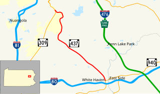
Pennsylvania Route 437 is an 11.2-mile-long (18.0 km) state highway located in Luzerne County in Pennsylvania. The southern terminus is at PA 940 in White Haven. The northern terminus is at PA 309 in the Fairview Township community of Mountain Top. PA 437 runs southeast-northwest through forested mountain areas as a two-lane undivided road. The roadway was paved by 1930 and designated PA 437 in the 1960s.

Course of San Juan Creek

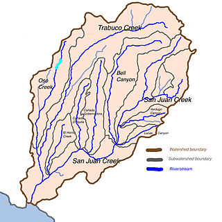
San Juan Creek is a creek in Orange County in the U.S. state of California. It is about 29 miles (47 km) long, and along with its major tributary, Trabuco Creek, drains 133 square miles (340 km2) near the southernmost extent of Orange County. This article describes the course of San Juan Creek.

Wadestown, West Virginia Unincorporated community in West Virginia, United States

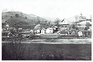
Wadestown — formerly West Warren — is an unincorporated community in Monongalia County, West Virginia, USA. It is located on West Virginia Route 7 about 7.5 miles (12.1 km) west-southwest of Blacksville.

Green Creek (Fishing Creek tributary) tributary of Fishing Creek in Columbia County, Pennsylvania

Green Creek is a tributary of Fishing Creek in Columbia County, Pennsylvania, in the United States. It is approximately 12.7 miles (20.4 km) long and flows through Jackson Township, Greenwood Township, and Orange Township. The watershed of the creek has an area of 36.8 square miles (95 km2). Green Creek has three named tributaries: Little Green Creek, Rickard Hollow, and Mud Run. The creek is not designated as an impaired waterbody and is a relatively large stream, contributing a significant amount of water to Fishing Creek. A valley known as the Greenwood Valley is located in the vicinity of Green Creek. The creek's own valley was likely affected by glaciation during the Ice Age.

West Branch Run tributary of Little Fishing Creek in Lycoming and Columbia Counties, Pennsylvania

West Branch Run is a tributary of Little Fishing Creek in Lycoming County and Columbia County, in Pennsylvania, in the United States. It is approximately 7.3 miles (11.7 km) long and flows through Jordan Township, Lycoming County and. The area of the stream's watershed is 10.20 square miles (26.4 km2). The stream's only named tributary is Shingle Run. West Branch Run flows through a valley known as California Hollow, which is listed as a "locally significant site" on the Columbia County Natural Areas Inventory. The Shoemaker Covered Bridge also crosses the stream, as does at least one other bridge in Lycoming County.

Beaver Run (Bowman Creek tributary) river in Pennsylvania, United States of America

Beaver Run is a tributary of Bowman Creek in Luzerne County and Wyoming County, in Pennsylvania, in the United States. It is approximately 7.7 miles (12.4 km) long and flows through Lake Township in Luzerne County and Noxen Township in Wyoming County. The watershed of the stream has an area of 10.6 square miles (27 km2). It is not designated as an impaired waterbody. The surficial geology in its vicinity includes alluvial fan, alluvial terrace, alluvium, Wisconsinan Till, Wisconsinan Ice-Contact Stratified Drift, fill, wetlands, and bedrock.

Kennedy Creek (Pennsylvania) river in the United States of America

Kennedy Creek is a tributary of South Branch Tunkhannock Creek in Lackawanna County, Pennsylvania, in the United States. It is approximately 5.3 miles (8.5 km) long and flows through Scott Township and North Abington Township. The watershed of the creek has an area of 6.17 square miles (16.0 km2). The creek is not designated as an impaired waterbody. The surficial geology in its vicinity consists of Wisconsinan Till, alluvium, bedrock, and fill.

Field Brook

Field Brook is a tributary of Tunkhannock Creek in Susquehanna County and Wyoming County, in Pennsylvania, in the United States. It is approximately 5.8 miles (9.3 km) long and flows through Lathrop Township in Susquehanna County and Nicholson Township in Wyoming County. The watershed of the stream has an area of 7.41 square miles (19.2 km2). The stream has one named tributary, which is known as East Branch Field Brook. The surficial geology in the vicinity of Field Brook consists of alluvium, Wisconsinan Till, alluvial terrace, alluvial fan, bedrock, wetlands, and a lake. The watershed of the stream is designated as a Coldwater Fishery and a Migratory Fishery.

West Branch Neshaminy Creek

West Branch Neshaminy Creek is one of two branches of the Neshaminy Creek, the other being the North Branch, part of the Delaware River watershed. It is located in Bucks and Montgomery Counties in Pennsylvania.

References

  1. U.S. Geological Survey. National Hydrography Dataset high-resolution flowline data. The National Map, accessed May 26, 2011