
Dadford is a hamlet in the parish of Stowe in north Buckinghamshire, England.
Boycott is a hamlet in the parish of Stowe in north Buckinghamshire, England.

Filgrave is a hamlet in the Borough of Milton Keynes and ceremonial Buckinghamshire, England. It is about three miles north of Newport Pagnell.

Upper Weald, Middle Weald and Lower Weald are three hamlets in the parish of Calverton in the Borough of Milton Keynes, England. They are located to the south east of the village centre, all three on the road to Whaddon.
Upton is a hamlet in the civil parish of Dinton-with-Ford and Upton, in Buckinghamshire, England. It is located to the north of the main village of Dinton, on the junction between the new road from Aylesbury to Thame, and the old road before it was rerouted.

Cotes is a hamlet and very small civil parish near the town of Loughborough in Leicestershire, England.Cotes has a population of about 50. At the 2011 census the population remained less than 100 and was included in the civil parish of Burton on the Wolds.

Wycomb is a small village in northern Leicestershire, England. It is in the Melton district, about 4 miles (6.4 km) from Melton Mowbray. It is part of the civil parish of Scalford.
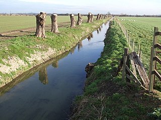
The River Ouzel, also known as the River Lovat, is a river in England, and a tributary of the River Great Ouse. It rises in the Chiltern Hills and flows 20 miles north to join the Ouse at Newport Pagnell.

Waldridge is an ancient village in the civil parish of Dinton-with-Ford and Upton in Buckinghamshire, England. Although little of the village survives today, the Waldridge Manor in the nearby village of Meadle shows the approximate location of the original settlement of Waldridge Village.

The A105 road is an A road in London, England. It runs from Canonbury, in between Highbury and Dalston, to Enfield Town. The road is 8 miles (13 km) long. Part of the road forms Green Lanes, one of the longest streets in London, while the A105 also serves as the primary access route to the Shopping City shopping centre.
Round Spinney is a locality in the north-east of the English town of Northampton.
Queen's Park is a district of the town of Northampton, England.

The River Kenwater is a short tributary of the River Lugg. It is also an offshoot of that river, separating from it about 2 kilometres north-west of Leominster at 52.2371807°N 2.7580419°W; it flows through the town and re-joins the Lugg just outside Leominster's east boundary, at 52.2304265°N 2.7315747°W.
Furzton is a district in West Milton Keynes in the civil parish of Shenley Brook End, Buckinghamshire, England. The man-made Furzton Lake is a balancing lake that covers approximately half of the district.
The hamlet of Beacon Hill, is situated off the B474 near Penn and on the outskirts of High Wycombe Buckinghamshire. Nearby is the Golf Course at Wycombe Heights.
Wootton Brook is a tributary of the River Nene which runs through Northamptonshire. The brook begins south of Great Houghton flowing south west through Preston Deanery and then east in the valley between Collingtree, Grange Park and East Hunsbury. It then flows south of West Hunsbury joining the River Nene at the west side of Northampton at Upton Mill. A number of small streams join the Brook along the way. In 1992 the stream overflowed into properties in parts of West Hunsbury.
Blurton is a district in the south of Stoke on Trent, in the English county of Staffordshire. Hollybush, Old Blurton, Blurton Farm and Newstead are the names of the areas in Blurton. The total population of the two Blurton wards at the 2011 census was 11,507.

The Newport Pagnell Canal was a 1.25 mile canal that ran from the Grand Junction Canal at Great Linford to Newport Pagnell through seven locks. Construction was authorised by an Act of Parliament in June 1814 and it probably opened in 1817. It closed in 1864, with part of the route used for the line of a railway.
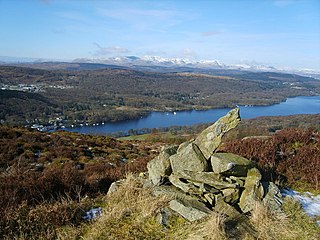
Staveley Fell is an upland area in the English Lake District, near Staveley-in-Cartmel, Cumbria, east of the southern end of Windermere. It is the subject of a chapter of Wainwright's book The Outlying Fells of Lakeland, but he admits that: "Strictly it has no name, not even locally, being referred to on Ordnance maps as Astley's and Chapel House Plantations, which are new forests severely encroaching upon it". He says it "commands a fine aerial view of the foot of Windermere." The fell reaches 870 feet (270 m) and Wainwright's route is a clockwise loop starting from Staveley-in-Cartmel. Chris Jesty in his revised edition of Wainwright's book provides an alternative route and comments that "There must be many people who, encouraged by the ordnance Survey map, or by the first edition of this book, have ... been turned back by an uncrossable fence."

Cotton End is a small district of the town of Northampton, England, about half a mile south of the town centre, north of the area known as Far Cotton and west of the road from South Bridge to Ransome Road known as Cotton End. The district population is included in the Delapre and Briar Hill Ward of Northampton Council.


