White Jade River

Last updated
Yurungkash River
White Jade River, Baiyu River
Collecting jade in the White Jade River near Khotan.jpg
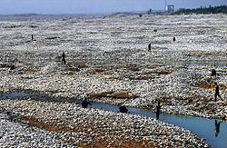
Collecting jade in the White Jade River near Khotan in 2011
Native name
  • يورۇڭقاش دەرياسى  (Uighur)
  • 玉龙喀什河  (Chinese)
Physical characteristics
Source Kunlun Mountains
  coordinates 35°31′38″N81°29′42″E / 35.527297°N 81.495070°E / 35.527297; 81.495070
Mouth Hotan River
  coordinates
38°04′53″N80°33′45″E / 38.081296°N 80.562477°E / 38.081296; 80.562477 Coordinates: 38°04′53″N80°33′45″E / 38.081296°N 80.562477°E / 38.081296; 80.562477
Basin size14,575 km2 (5,627 sq mi)
Discharge 
  average72.3 cubic metres per second (2,550 cu ft/s)
Basin features
Progression HotanTarimTaitema Lake
  1. From map: "DELINEATION OF INTERNATIONAL BOUNDARIES MUST NOT BE CONSIDERED AUTHORITATIVE".
  2. From map: "THE DELINEATION OF INTERNATIONAL BOUNDARIES ON THIS MAP MUST NOT BE CONSIDERED AUTHORITATIVE."
  3. From map: "The representation of international boundaries is not necessarily authoritative."

Related Research Articles

Karakash River

The Karakash or Black Jade River, also spelled Karakax, is a river in the Xinjiang autonomous region of the People's Republic of China that originates in the disputed Aksai Chin region administered by China. It passes through the historical settlement of Xaidulla and passes by the city of Khotan (Hotan) to flow northeast in the Tarim Basin. It merges with the Yurungkash River, the combined river taking the name Hotan River and flowing into the Tarim River.

Hotan County-level city in Xinjiang, Peoples Republic of China

Hotan is a major oasis town in southwestern Xinjiang, an autonomous region in Western China. The city proper of Hotan broke off from the larger Hotan County to become an administrative area in its own right in August 1984. It is the seat of Hotan Prefecture.

Tarim Basin Endorheic basin in Northwest China

The Tarim Basin is an endorheic basin in Northwest China occupying an area of about 1,020,000 km2 (390,000 sq mi) and one of the largest basins in Northwest China. Located in China's Xinjiang region, it is sometimes used synonymously to refer to the southern half of the province, or Nanjiang, as opposed to the northern half of the province known as Dzungaria or Beijiang. Its northern boundary is the Tian Shan mountain range and its southern boundary is the Kunlun Mountains on the edge of the Tibetan Plateau. The Taklamakan Desert dominates much of the basin. The historical Uyghur name for the Tarim Basin is Altishahr, which means 'six cities' in Uyghur.

Aksu City County-level city in Xinjiang, Peoples Republic of China

Aksu is a city in and the seat of Aksu Prefecture, Xinjiang, lying at the northern edge of the Tarim Basin. The name Aksu literally means "white water" and is used for both the oasis town and the Aksu River.

Aksu Prefecture Prefecture in Xinjiang, Peoples Republic of China

Aksu Prefecture is located in mid-Western Xinjiang, People's Republic of China. It has an area of 131,161 km2 (50,642 sq mi) and 2.37 million inhabitants at the 2010 census whom 535,657 lived in the built-up area made up of Aksu urban district. The name Aksu is Turkic for 'white water'. Aksu Prefecture has a 263.8 km (163.9 mi) long international boundary with Kyrgyzstan and Kazakhstan.

Artux County-level city in Xinjiang, Peoples Republic of China

Artux, Artush, and officially rendered as Atushi, is a county-level city and the capital of the Kyrgyz autonomous prefecture of Kizilsu in Xinjiang, China. The government seat is in Guangminglu Subdistrict (光明路街道).

Hotan River

The Hotan River is formed by the union of the White Jade (Yurungkash) and Karakash Rivers, which flow north from the Kunlun Mountains into the Taklamakan Desert in northern China. The two rivers unite towards the middle of the desert, some 145 kilometres (90 mi) north of the town of Hotan. The river then flows 290 kilometres (180 mi) northwards across the desert and empties itself into the Tarim River. Because the river is fed by melting snow from the mountains, it only carries water during the summer and is dry the rest of the year. Prior to construction of the Tarim Desert Highway in 1995, the Hotan river bed provided the only transportation system across the Tarim Basin.

Awat County County in Xinjiang, Peoples Republic of China

Awat County is a county in Aksu Prefecture, Xinjiang Uyghur Autonomous Region, China. Awat County is located on the southern foot of the Tian Shan mountain range and on the northern edge of the Taklamakan Desert.

Niya County County in Xinjiang, Peoples Republic of China

Niya County, also from Mandarin Chinese as Minfeng County, is a county within the Xinjiang Uyghur Autonomous Region and is under the administration of the Hotan Prefecture. It contains an area of 56,726 km2 (21,902 sq mi). According to the 2002 census, it has a population of 30,000. The county is bordered to the north by Xayar County, to the east by Qiemo/Qarqan County, to the west by Yutian / Keriya County and to the south by Ngari Prefecture in Tibet.

Qira County, alternatively Chira or Cele, is a county in Hotan Prefecture, Xinjiang Uyghur Autonomous Region, China. Almost all the residents of the county are Uyghurs and live around oases situated between the desolate Taklamakan Desert and Kunlun Mountains. The county is bordered to the north by Aksu Prefecture, to the east by Yutian / Keriya County, to the northwest by Lop County, to the southwest by Hotan County including the China-India disputed Aksai Chin area and to the south by Rutog County, Ngari Prefecture in Tibet.

Yutian County, Xinjiang County in Xinjiang, Peoples Republic of China

Yutian County, also transliterated from Uyghur as Keriya County, is a county in Hotan Prefecture, Xinjiang Uyghur Autonomous Region, China. It contains an area of 39,023 km2 (15,067 sq mi). According to the 2002 census, it has a population of 220,000. Its government is located at Keriya Town. The county is bordered to the north by Aksu Prefecture, to the east by Minfeng/Niya County, to the west by Qira County and to the south by Rutog County and Gêrzê County in Ngari Prefecture, Tibet.

Lop County, also Luopu, is a county in Hotan Prefecture, in the southwest of the Xinjiang Uyghur Autonomous Region, China. Almost all the residents of the county are Uyghur and live around oases situated between the desolate Taklamakan Desert and Kunlun Mountains. The county is bordered to the north by Aksu and Awat County in Aksu Prefecture, to the east by Qira/Chira County, to the northwest by Karakax County, to the west by Hotan (Khotan) and to the south and west by Hotan County.

Hotan County County in Xinjiang, Peoples Republic of China

Hotan County is a county in the southwest of the Xinjiang Uyghur Autonomous Region and is under the administration of the Hotan Prefecture. Almost all the residents of the county are Uyghurs and live around oases situated between the desolate Taklamakan Desert and Kunlun Mountains. Hotan County is the southernmost county-level division of Xinjiang. The county borders Karakax/Moyu County to the northwest, Hotan City and Lop County to the northeast, Qira County to the east, Pishan County to the west, and Rutog County, Tibet to the southeast. Hotan County administers most of Aksai Chin, an area disputed between China and India. The Line of Actual Control divides the India-controlled part of Ladakh union territory from the Aksai Chin area administered as part of southwest Hotan County.

Hotan Prefecture Prefecture in Xinjiang, Peoples Republic of China

Hotan Prefecture is located in the Dzungaria region in the southwestern part of the Xinjiang Uygur Autonomous Region, China, bordering the Tibet Autonomous Region to the south and Union Territory of Ladakh and Gilgit-Baltistan to the west. The vast majority of the Aksai Chin region which is disputed between China and India is administered as part of Hotan Prefecture. The seat of Hotan Prefecture is Hotan and its largest county by population is Karakax County. The vast majority of the residents of the prefecture are Muslim Uyghurs and live around oases situated between the desolate Taklamakan Desert and Kunlun Mountains.

Hotan Airport

Hotan Airport or Hotan Aerodrome, is an airport serving Hotan, a city in the autonomous region of Xinjiang in China.

Hindutash

Hindutash, also known as Hindu-tagh Pass, is a historical mountain pass in the western Xinjiang, China. The pass cuts through the Kunlun Mountains connecting the now-deserted town of Kangxiwar in the Karakash River valley to the town of Pusha in the Yurungkash River valley. It also connects to the road to the city of Hotan.

Dahongliutan Place in Xinjiang, China

Dahongliutan or simply Hongliutan is a village situated in Karakash river valley in the Hotan County, Hotan Prefecture, Xinjiang, China. It is located along the China National Highway 219, and is the town just north of the disputed Aksai Chin region of China and India.

Aksai Chin Lake Endorheic lake in Chinese-administered Kashmir

Aksai Chin Lake or Aksayqin Lake, is an endorheic lake in the disputed Aksai Chin region of Kashmir. The plateau is administered by China but also claimed by India. Its Tibetan/Ladakhi name is Amtogor Lake which means "encounter with a round object".

Keriya River

The Keriya River is a river in the province of Xinjiang in China. It flows for 519 km (322 mi) from the Kunlun Shan mountain range north into the endorheic Tarim Basin, but is lost in the desert several hundred kilometers south of the Tarim River. The only major settlement along the river is Keriya Town, east of Hotan. The river is an important source of irrigation water and also supplies historically important oases along its course. Its drainage basin covers about 7,358 km2 (2,841 sq mi).

Mazartag

Mazartag is an arc-shaped mountain range located in the western part of Tarim Basin, between the Hotan and Yarkand river valleys, Xinjiang, China. It is some 145 km long and 3 to 5 km wide; the highest peak rises to 1,635 m. The range is mainly composed of sandstone.

References

  1. 1 2 3 Jacobs, Andrew (September 20, 2010). "Jade from China's West Surpasses Gold in Value". The New York Times . Retrieved November 16, 2018.
  2. Moore, Malcolm (August 8, 2008). "White jade rush in China's Wild West". The Daily Telegraph . Retrieved November 16, 2018.
White Jade River
Uyghur name
Uyghur يورۇڭقاش دەرياسى